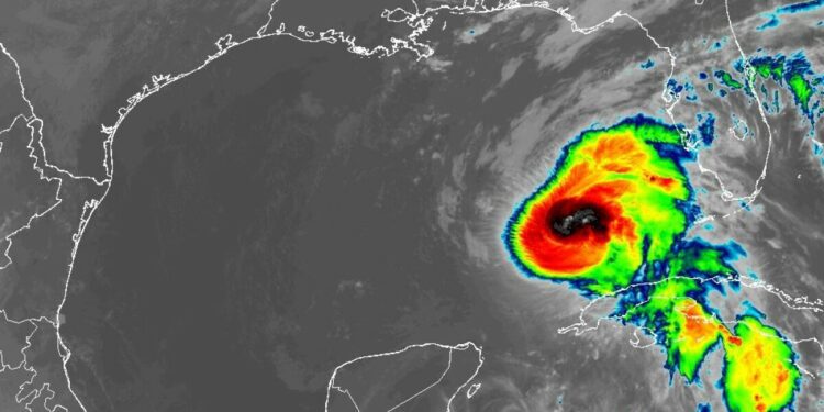
Hurricane Rafael pushed into the Gulf of Mexico on Wednesday night after plowing across western Cuba as a Category 3 hurricane with winds so powerful it knocked out the entire country’s power grid.
Massive waves lashed at the shores of Havana as sharp winds and rain whipped at the city’s historic center, leaving trees littered on flooded streets on Wednesday evening.
Forecasters warned Rafael could bring “life-threatening” storm surges, winds and flash floods to western swaths of the island after it knocked out power and dumped rain on the Cayman Islands and Jamaica the day before. The extent of the damage was still unclear as of Wednesday night.
Meteorologist Megan Borowski, with the Florida Public Radio Emergency Network, said Rafael could also produce more additional bands of storms across the Florida Keys.
She said some coastal areas across the greater Tampa Bay region could also see some impacts Thursday.
READ MORE: Helene’s wrath appears to have flattened most of the dunes on Pinellas beaches
“Rafael’s center should track west northwestward into the open Gulf today (Thursday), but there’s a very humid environment over the state of Florida and we are expecting bands of thunderstorms to track through the Keys and the southwest peninsula today around the edge of Raphael’s circulation,” Borowski said. “A few of those thunderstorms could become strong.
“Winds over the Gulf waters will become stiff and rough surf, dangerous currents and beach erosion will be possible for beaches from the Keys to all the way up to Clearwater today.”
The storm is bad news for Cuba, which is struggling with devastating blackouts while recovering from another hurricane two weeks ago that killed at least six people in the eastern part of the island.
Earlier on Wednesday, the Cuban government issued an alert for the incoming storm while crews in Havana worked to fortify buildings and clear scraps from seaside areas in anticipation of flooding.
Classes and public transport were suspended on parts of the island and authorities canceled flights in and out Havana and Varadero. Meanwhile, thousands of people in the west of the island were evacuated as a prevention measure.
Silvia Pérez, a 72-year-old retiree living in a coastal area of Havana was among those scrambling to prepare. As other neighbors moved appliances and other furniture from ground floor homes, Pérez stocked up on water and food.
“This is a night I don’t want to sleep through, between the battering air and the trees,” Pérez said. “I’m scared for my friends and family.”
Forecasters expected the storm to weaken over Cuba before emerging in the southeastern Gulf of Mexico as a hurricane.
The U.S. State Department issued an advisory for Cuba on Tuesday afternoon, offering departure flights to non-essential staff and American citizens, and advising others to “reconsider travel to Cuba due to the potential impact of Tropical Storm Rafael.”
On Tuesday morning, the Cuban Civil Defense called on Cubans to prepare as soon as possible, because when the storm makes landfall “it’s important to stay where you are.”
A hurricane warning was in effect Wednesday for the Cuban provinces of Pinar del Rio, Artemisa, La Habana, Mayabeque, Matanzas and the Isle of Youth.
A tropical storm warning was in effect for the Cuban provinces of Villa Clara, Cienfuegos, Sancti Spiritus and Ciego de Avila, as well as the lower and middle Florida Keys from Key West to west of the Channel 5 Bridge, and Dry Tortugas.
The storm on Tuesday knocked out power in parts of Jamaica and unleashed flooding and landslides. The Jamaica Public Service, the island’s electricity provider, said in a statement late Tuesday that impassable roads were preventing crews from restoring power in some areas.
Power outages were reported across the Cayman Islands after a direct hit late Tuesday, and schools remained closed on Wednesday.
“While conditions have improved on Grand Cayman, residents are advised to exercise extreme caution on the roads and near coastlines as rough seas and residual flooding risks may persist,” the government said in a statement.
Heavy rainfall also was expected to spread north into Florida and nearby areas of the southeast U.S. during the middle to late part of the week. The Hurricane Center predicted storm surges in Florida could reach up to 3 feet in Dry Tortugas and between 1 and 2 feet in the Lower Florida Keys. A few tornadoes also were expected Wednesday over the Keys and southwestern Florida.
Rafael is the 17th named storm of the season.
The National Oceanic and Atmospheric Administration predicted the 2024 hurricane season was likely to be well above average, with between 17 and 25 named storms. The forecast called for as many as 13 hurricanes and four major hurricanes.
An average Atlantic hurricane season produces 14 named storms, seven of them hurricanes and three major hurricanes.
Florida Public Radio Emergency Network meteorologist Megan Borowski contributed to this report.
Source link : http://www.bing.com/news/apiclick.aspx?ref=FexRss&aid=&tid=672cfa3fee6e4cb9895fa2cf279b5564&url=https%3A%2F%2Fwww.wusf.org%2Fweather%2F2024-11-07%2Fhurricane-rafael-coastal-impacts-tampa-area-could-see-effects&c=16446175309348353415&mkt=en-us
Author :
Publish date : 2024-11-07 02:18:00
Copyright for syndicated content belongs to the linked Source.


