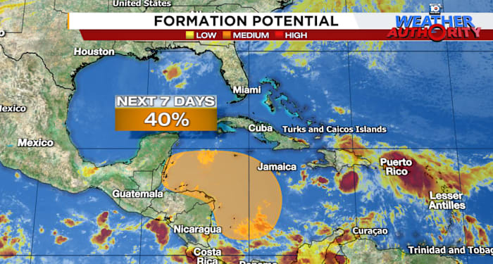
With Rafael quickly spinning down over the Gulf of Mexico this weekend – its thunderstorm activity wiped clear by a slug of dry air and hostile wind shear – we’d hope the hurricane season would finally come to its senses and move into its traditional November hibernation, but the Caribbean has other plans.
Leer en español
Yet another system is expected to come together by later this week or this weekend in the western Caribbean and has a chance at taking advantage of some unusually conducive late-season conditions to strengthen into the early part of next week.
Similar to Rafael, the big question is how long it takes to cook and whether it moves quickly inland over Central America, finds a fast escape route into the Atlantic, or loiters into next week. It’s too soon to know which door it’ll chose, but the last door is the one that could make it a player for Florida.
Pieces coming together this week
The system will come about from a westward moving tropical wave centered on the central Caribbean and Hispaniola today and a strip of storminess and spin – a feature known as the monsoon trough – stretching into the southwestern Caribbean from the eastern Pacific.
The combined areas of spin and storminess will slowly congeal in the days ahead off the coasts of Honduras and Nicaragua and our major forecast models – including the American GFS and European – now agree we should see development of a depression or named storm by late week or the weekend.
The next name on the list is Sara.
Three doors ahead
Where it heads next week will come down to how quickly and where, relative to Central America, the system forms.
Low pressure tracks from the European model through early next Wednesday (November 20th) showing three doors the system might take: Door #1 An escape to the Atlantic this weekend, Door #2 A prolonged threat to Central America from this weekend into early next week, and Door #3 A more concerning scenario for Florida by next Tuesday and Wednesday (November 19th and 20th). It’s too soon to know which door the system will choose, but development appears likely by this weekend. Credit: Weathernerds.org.
If the system comes together sooner and farther from Central America, it could get yanked north by an approaching cold front diving through Florida and into the southwestern Atlantic this weekend. This scenario would put eastern Cuba, Jamaica, Haiti, and the Dominican Republic in play for impacts this weekend but lessen the risk for areas west.
On the other hand, if the system develops closer to Central America, there’s also a chance it could miss the front and drift inland over Central America under light steering, perhaps even dissipating as it pivots over land into early next week. This scenario would be problematic for parts of Central America for prolonged and potentially significant impacts.
The third door has the front bypassing the system this weekend, but loitering off the coast of Central America and over the western Caribbean into early next week. This is more concerning for areas north – including Mexico’s Yucatán Peninsula, western Cuba, and Florida – as environmental conditions will grow more favorable for strengthening and steering currents could take it northward come next Monday and Tuesday.
Wind shear departure from average for next Tuesday, November 19th from the European forecast model ensemble system. The dark blue areas show much-below-average wind shear for the early part of next week in the northwestern Caribbean and southern Gulf of Mexico near Florida that could favor organization should a system move northward. Credit: TropicalTidbits.com.
Any of these three doors is a possibility and our models show the scenarios clearly. It’s worth noting a threat to Florida this late in the season – particularly into the third week of November – would be a rare, though not unprecedented, event. In the modern record (since 1966), only Gordon (1994), Keith (1988), and Kate (1985), have struck Florida beyond mid-November, and only one of these (Kate in 1985) was a hurricane at landfall.
For now, it’s just something we’ll want to monitor in the days ahead here in Florida. We have time to follow the trends, and the time of year often works in our favor.
As much as we want to put this drawn-out season to bed, we’ll need to get through this one first before we can finally cede the weather worries to our friends up north.
Copyright 2024 by WPLG Local10.com – All rights reserved.
Source link : http://www.bing.com/news/apiclick.aspx?ref=FexRss&aid=&tid=67334aaf81c944198df1f5e7d9af6cec&url=https%3A%2F%2Fwww.local10.com%2Fweather%2Fhurricane%2F2024%2F11%2F11%2Fhurricane-season-not-done-yet-another-storm-lurking-for-later-this-week%2F&c=1312902196684730579&mkt=en-us
Author :
Publish date : 2024-11-11 06:25:00
Copyright for syndicated content belongs to the linked Source.


