Cruising yachts and other sailing vessels head south as Hurricane Beryl expected to hit Windward Islands including Grenada and the Grenadines
Cruisers and other sailing yachts have been evacuating Grenada and many Caribbean islands as Hurricane Beryl is currently tracking towards the Windward Islands, expected to make landfall later today, Monday 1 July.
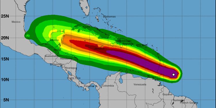
Beryl is a uniquely early tropical storm that reached Category 4 strength (wind speeds of 131-155 mph) yesterday, Sunday 30 June. Although it has currently been downgraded to a Category 3, is still expected to inflict devastating wind speeds (111-130 mph) and a 6-10ft storm surge on many Caribbean islands, particularly Grenada, St Vincent and the Grenadines.
AIS screen grab showing yachts evaluating Grenada and windward islands on 30 June ahead of Hurricane Beryl. Source: MarineTraffic
Yesterday AIS trackers showed a flotilla of over 100 yachts and other vessels pouring out of Grenada to head south, primarily towards Trinidad, while some headed west to the ABCs. Tobago, however, is expected to fall within the Hurricane’s path.
The Trinidad Cruisers Association Facebook Group is updating its page with latest information for arrivals, including safe anchorages and storm shelter locations. Customs fees have been waived for arriving yachts and anyone arriving with a pet who has not got a Trinidad pet permit is advised to join the Trinidad Cruisers Whatsapp group (number on link) and message organiser Jesse James for assistance in special circumstances.
Cruisers have also been assisting fellow boats struggling to evacuate, including one vessel with a 1 year old and 3 year old child onboard who lost engine power whilst en route from Granada. They were assisted by another sailing vessel and safely towed into Chaguaramas, Trinidad.
June Hurricane Beryl
Beryl is the earliest major hurricane – ie Category 3 or over – to form in the Atlantic in over 58 years. Whilst Hurricane season is defined as running from 1 June to 30 November, it is rare for such a severe tropical storm to form so early in the season.
Berly is also rare in how it has formed: the storm took just 42 hours to strengthen from a tropical depression to a major hurricane, and it is rare for a hurricane to form this far south east.
Grenada is usually considered to be below the hurricane belt – some yacht insurance companies have historically specified 12°30’N as the official limitation, which means anchorages on the far south of the island are theoretically below it (others define the southern edge of their named winter storm area as far down as 9°N, which includes Trinidad and Tobago).
Grenada has not experienced a severe hurricane since 2004, when Category 3 Hurricane Ivan hit the southeast Caribbean, causing catastrophic damage.

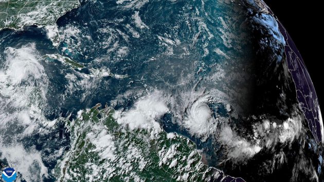
National Oceanic and Atmospheric Administration satellite shows hurricane Beryl, lower right, as it strengthens over the Atlantic Ocean and heads toward the southeast Caribbean on Saturday, June 29, 2024. NOAA via AP/Alamy images
Hurricane warnings
Hurricane warnings are currently in effect for Barbados, St. Lucia, Grenada, Tobago, St. Vincent and the Grenadines. A state of emergency has been declared in Grenada, with storm shelters open. Airports in Barbados, Grenada and Saint Lucia have been closed since Sunday. Tobago’s meteorological service has issued a Red warning for the island – their most severe weather alert.
“I want everybody in Saint Vincent and the Grenadines to take this matter very seriously,” Prime Minister Ralph Gonsalves said. “There are some persons who are hoping for the best, and we must all do that, but we all have to prepare for the worst.”
Trinidad and Tobago Meteorological Service issued the following advisory notice this morning: “Tobago can expect a gradual deterioration in conditions, beginning with periods of showers and gusty winds in excess of 70km/h over the next few hours. There is a high chance (80%) of hazardous seas with large, battering waves. Mariners should expect wave heights to increase significantly, posing a danger to small craft, coastal and offshore activities.”

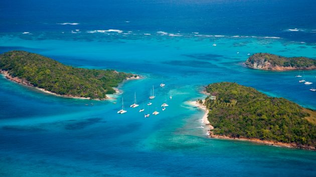
The stunning Tobago Cays in the Grenadines are some of the most popular cruising spots in the region. Photo: Peter Phipp/Travelshots.com/Alamy
Tropical storm warnings are also in effect for Martinique and Trinidad, according to the US’s National Hurricane Center. Less severe tropical storm watches are also in place in parts of the Dominican Republic and the southern coast of Haiti.
The storm is expected to drop up to six inches (15cm) of rain on Caribbean islands including Barbados.
Forecasters have been predicting an exceptional hurricane season for 2024, with an above average of named and severe storms. The US National Oceanic and Atmospheric Administration is predicting 17 to 25 storms, 8 to 13 hurricanes and 4 to 7 major hurricanes of Category 3 or higher this summer and autumn. An average Atlantic hurricane season typically produces 14 named storms, seven of which are hurricanes and three major hurricanes.
Source link : https://www.yachtingworld.com/all-latest-posts/unprecedented-june-hurricane-beryl-set-to-hit-windward-islands-yachts-evacuate-152244
Author :
Publish date : 2024-07-01 04:47:38
Copyright for syndicated content belongs to the linked Source.


