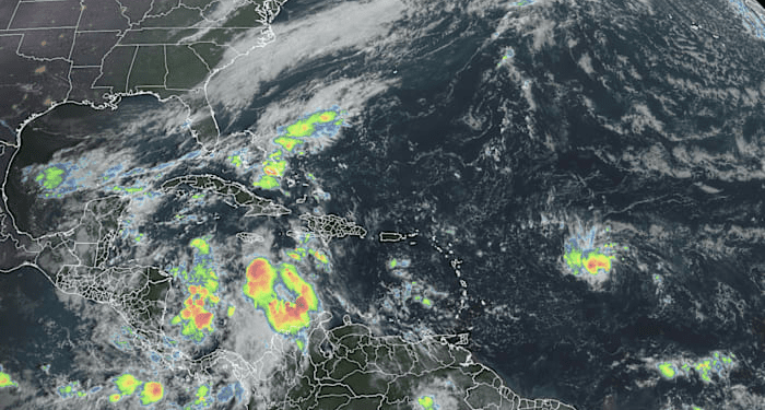
We continue to follow a disturbance dubbed Invest 94L tracking westward through the central Atlantic. Though not unheard of, the almost due-west course from the deep tropical Atlantic is an unusual trajectory for a system this late in the season, when developing systems most often turn quickly north and east once they’re in the vicinity of the Caribbean.
No description found
Although the development zone appears threatening for the mainland U.S. at first glance, 94L will fall short of posing any problems for us stateside next week as it encounters a firehose of wind shear guarding U.S. shorelines, courtesy of reinforcing fall cold fronts.
If 94L becomes a Tropical Depression or Nadine over the next few days, models show it either dropping southward and weakening through the Windward Passage between Cuba and Hispaniola or getting torn up and flung out to sea and away from the U.S.
Odds of 94L passing to within about 100 miles of any given location based on the overnight runs of our most reliable global forecast models. Forecast models indicate the disturbance or what forms from it will either weaken and drop southward into the western Caribbean or get quickly flung northward and away from the U.S. The system isn’t expected to pose a threat to the mainland U.S. as hostile wind shear surrounds nearby waters deep into next week. Credit: Tomer Burg/University of Oklahoma.
Either way, 94L isn’t expected to make it very far before succumbing to the winds of climatology.
Rainmaker for the Greater Antilles
As we mentioned in yesterday’s newsletter, because the low-pressure circulation is well-established, it wouldn’t take much additional organization to its thunderstorms for 94L to get upgraded to a tropical depression or Tropical Storm Nadine.
That said, models have generally backed away from doing very much with 94L in the coming days, and NHC bumped development odds down from 60% to 40% over the past 24 hours.
Even if 94L doesn’t find its footing, the system may track close enough to the islands – including Puerto Rico and the U.S. Virgin Islands – beginning on Friday to increase storminess and cause some localized flooding issues. If it slows down on Saturday or early Sunday near Haiti and the Dominican Republic, it could also worsen the heavy rain threat across the mountainous terrain of Hispaniola.
Another disturbance to bring flooding rains to Central America
Meanwhile, a more significant rain event is shaping up for parts of Central America over the next few days. A broad area of storminess over the southwestern Caribbean – associated with the Central American Gyre or CAG – is expected to pivot westward into parts of Honduras, Guatemala, Belize and southern Mexico over the next several days and into the weekend.
Total rainfall forecast through next Tuesday, October 22nd, from the European forecast model for Central America and southern Mexico showing widespread totals of 6-12 inches (150-300 mm), with locally higher totals, from the disturbance in the southwestern Caribbean. Credit: Weathermodels.com.
Models don’t show much in the way of organized development, but hefty rain totals will likely lead to a widespread flood threat across the region through early next week.
Copyright 2024 by WPLG Local10.com – All rights reserved.
Source link : http://www.bing.com/news/apiclick.aspx?ref=FexRss&aid=&tid=671065450f404ca3a7900e3a45b52172&url=https%3A%2F%2Fwww.local10.com%2Fweather%2Fhurricane%2F2024%2F10%2F16%2Fmainland-us-and-florida-in-the-clear-from-approaching-atlantic-system%2F&c=16632494660273382395&mkt=en-us
Author :
Publish date : 2024-10-16 07:02:00
Copyright for syndicated content belongs to the linked Source.


