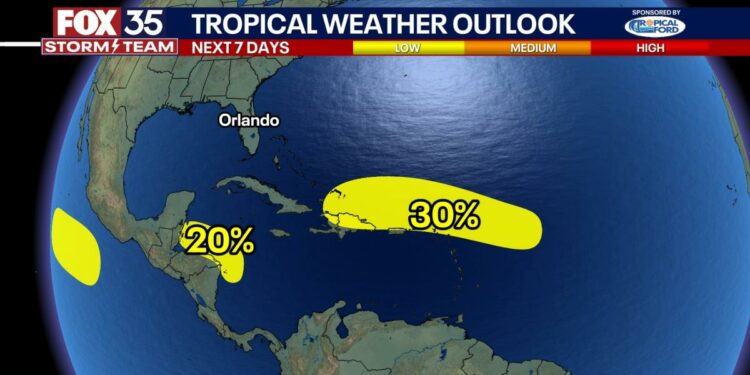
ORLANDO, Fla. – Two tropical disturbances in the Atlantic basin are being monitored, though neither shows strong signs of immediate development, according to the National Hurricane Center.
East of the Leeward Islands
A trough of low pressure located several hundred miles east of the Leeward Islands is producing disorganized showers and thunderstorms.
Environmental conditions in the region are only marginally conducive for development.
The disturbance is moving quickly westward to west-northwestward at around 20 mph.
It is expected to pass near the Virgin Islands and Puerto Rico by Friday, then approach the Greater Antilles over the weekend.
Western Caribbean Sea
A broad area of low pressure over the southwestern Caribbean Sea is also showing limited development potential.
Showers and thunderstorms associated with this system could develop slowly if the low stays over water as it moves slowly northwestward toward Central America.
Regardless of development, the system may bring locally heavy rainfall to parts of Central America and southern Mexico by the weekend.
Both systems should not affect Florida as the cold front moving through the state is acting as a shield. Both systems will continue to be monitored.
Source link : http://www.bing.com/news/apiclick.aspx?ref=FexRss&aid=&tid=671159d5c6f54e6a832a00fd7c035986&url=https%3A%2F%2Fwww.aol.com%2Fnews%2Finvest-94l-cold-front-protecting-120007146.html&c=641420176955065470&mkt=en-us
Author :
Publish date : 2024-10-17 04:00:00
Copyright for syndicated content belongs to the linked Source.


