
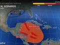
The 2024 Atlantic hurricane season is far from over, as AccuWeather hurricane experts are keeping an eye on the tropical basin for additional tropical storm formation over the next week, including in an area that has been rife with hurricanes this year.
An area of showers and thunderstorms expected to move into the western Caribbean late in the week could lead to another tropical storm. If it forms, it could head toward hurricane-weary Florida.
“Interests from Central America through the western Caribbean and the Gulf Coast of the U.S. should closely monitor this potential for development,” said AccuWeather Meteorologist Mike Youman.
While showers and storms were already present in the western Caribbean this weekend, it will take a few days for them to become more organized and potentially rotate and form an area of low pressure. Once that happens later in the new week, the water beneath the storms is ready to feed any potential storm.
GET THE FREE ACCUWEATHER APP
“Not only are waters very warm in this area-well into the 80s F down deep-the ocean heat content in the western Caribbean is at record high levels for any time of the year,” AccuWeather Lead Hurricane Forecaster Alex DaSilva said.
Hurricanes Beryl, Debby and Helene were all influenced by the abnormally warm water in this region so far this season, while Hurricanes Francine and Milton formed and quickly strengthened in a similar environment over the southern Gulf of Mexico. All of these storms eventually impacted the U.S.
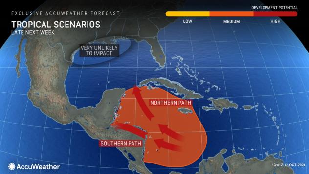

Since any potential formation is still about a week away, AccuWeather hurricane experts say there are multiple scenarios on the table for where any storm will move if it forms.
“One possibility would take the system westward into Central America and southern Mexico, and the other is, unfortunately, toward Florida,” DaSilva said, “It is typically very difficult for a tropical system to continue toward the northwest and into Texas this late in the season due to prevailing westerly breezes in that area.”
Just how strong any possible storm can get depends on its movement. A more southern and western track into Central America would leave little time over water for strengthening, while a northern trajectory toward the Gulf means more time over water and a greater chance of any storm strengthening into a hurricane.

As recovery and cleanup efforts continue in the wake of Hurricanes Helene and Milton, amid continuing flooding, Floridians and others near the central and eastern Gulf Coast of the U.S. should monitor the AccuWeather forecast for updates on any potential storm.
Elsewhere in the Atlantic, Tropical Storm Leslie lost wind intensity over the open Atlantic and degenerated into a broad area of low pressure on Saturday. It was expected to continue losing organization as it moves closer to the Azores and Western Europe early this week.
Another area being monitored for development was in association with an area of showers and thunderstorms a few hundred miles to the west of the Cabo Verde Islands off the western coast of Africa. This system faces an uphill climb after Saturday, as it will enter an environment more hostile for storm formation, but it does bear watching once it emerges from that near the northern Caribbean Islands late this week.
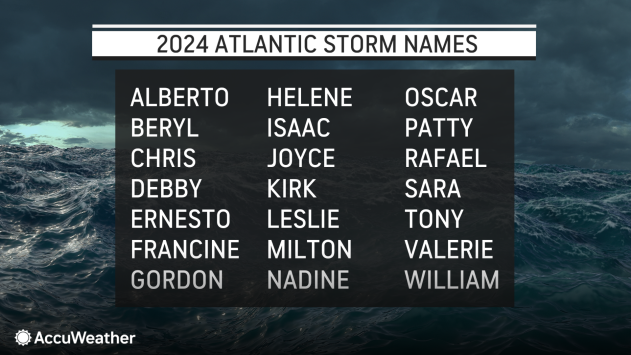
The next two names on the Atlantic list are Nadine and Oscar.
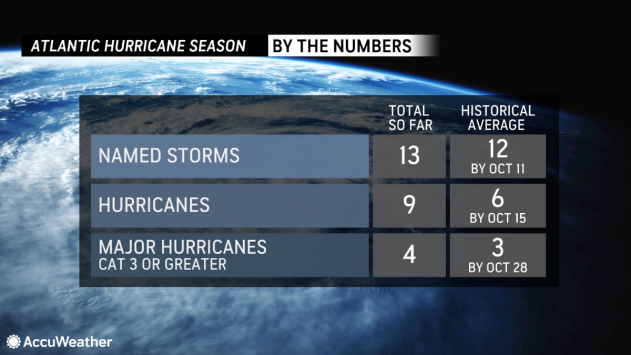
As AccuWeather accurately predicted, the Atlantic hurricane season has been busy. So far, the number of named storms, hurricanes and major hurricanes (Category 3 or stronger on the Saffir-Simpson Hurricane Wind Scale) is above historical averages for mid-October. The season runs from June 1 to Nov. 30.
Want next-level safety, ad-free? Unlock advanced, hyperlocal severe weather alerts when you subscribe to Premium+ on the AccuWeather app. AccuWeather Alerts™ are prompted by our expert meteorologists who monitor and analyze dangerous weather risks 24/7 to keep you and your family safer.
Source link : http://www.bing.com/news/apiclick.aspx?ref=FexRss&aid=&tid=670b9aea839046a29e503824bd9e8de4&url=https%3A%2F%2Fwww.aol.com%2Fweather%2Faccuweather-eyeing-western-caribbean-potential-142813476.html&c=3465536794181523621&mkt=en-us
Author :
Publish date : 2024-10-12 03:28:00
Copyright for syndicated content belongs to the linked Source.