While landfall is not currently forecast in SWFL, because of the anticipated size and strength of what will be #Helene, we WILL feel impacts.
WHEN? Wednesday night into Thursday
WHERE? All of SWFL, but especially along the coast. Stay tuned, as timing and threats could change. pic.twitter.com/2qJDhwL8Ls
— Katie Walls (@KatieWallsTV) September 23, 2024
2PM Update, Monday, September 23, 2024:
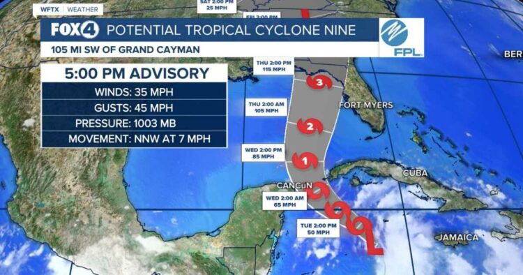
Hurricane Hunters are flying through Potential Tropical Cyclone Nine right now. That data will help us better know where the center is forming and environmental conditions into which it’s traveling.
Tropical Storm Warnings and Hurricane Watches are in effect for parts of Cuba and Mexico.
Maximum sustained winds are near 30 mph (45 km/h) with higher gusts. Strengthening is expected during the next few days, and the system is forecast to become a hurricane on Wednesday and continue strengthening as it moves across the eastern Gulf of Mexico.
Landfall is NOT forecast in SWFL at this time, but considering the expected size of the system, SWFL will feel impacts, especially along the coast.
Those impacts include winds in excess of 40 mph, heavy rain which may lead to localized flooding and 2-4 feet of surge along the coast, leading to coastal flooding.
WHEN? Wednesday night into Thursday
11AM Update, Monday, September 23, 2024:
The National Hurricane Center has initiated advisories on Potential Tropical Cyclone Nine in the western Caribbean. This is the first forecast cone on what will become Helene in the next day or two and eventually a hurricane in the Gulf of Mexico.
The movement is estimated to be north at 6mph, but is uncertain given the lack of organization. A gradual turn toward the northwest is expected during the next day or so, with the center passing through the Yucatan Channel and into the southern Gulf of Mexico. Thereafter, the system is forecast to accelerate northward across the eastern Gulf of Mexico within the flow between a digging deep-layer trough over the central United States and a ridge over the western Atlantic. This motion should bring the center of the system toward the northeastern Gulf Coast on Thursday.
Since the disturbance currently lacks a well-defined center, users are reminded that the average forecast track uncertainty is larger in these situations, and future track adjustments may be required. Given the large size of the tropical-storm-force wind field and fast forward speed that is forecast, storm surge, wind, and rainfall impacts will likely extend well away from the center, particularly to the east of the system.
While the system is currently broad and not well organized, the models suggest a more well-defined center should develop during the next day or so. Once the system becomes better organized and develops an inner core, the environmental and oceanic conditions appear favorable for significant strengthening.
8AM Update, Monday, September 23, 2024:
As of 8am, the likelihood of development this week has increased to 70% chance of next 2 days and 90% over the next 7 days.
Showers and thunderstorms are gradually becoming better organized in association with a broad area of low pressure located over the northwestern Caribbean Sea. Environmental conditions appear favorable for further development of this system. A tropical depression or storm is likely to form within the next day or two as the system moves northward across the northwestern Caribbean Sea and into the southeastern Gulf of Mexico, where additional development is expected.
Regardless of development, this system is expected to produce heavy rains over portions of Central America during the next several days. Interests in the northwestern Caribbean, the Yucatan Peninsula of Mexico, and western Cuba should closely monitor the progress of this system, as watches or warnings will likely be required later this morning for portions of these areas. Later this week, the system is forecast to move generally northward across the eastern Gulf of Mexico, and interests along the northern and northeastern Gulf Coast should also closely monitor the progress of this system.
Exact impacts for Southwest Florida are impossible to know at this point. However, based on the latest thinking, which is a strong hurricane moving north through the Gulf of Mexico and riding several hundred miles off our coast, our weather would start to deteriorate Wednesday evening into Thursday as the storm makes its closest approach. Currently the computer models are showing a potential landfall along the panhandle east towards the big bend of the state, but until this system develops and a center develops for the computer models to grab a hold off it is impossible to know an exact landfall location or exact impacts for Southwest Florida.
Watching the western Caribbean for the next hurricane
8PM Update, Sunday, September 22, 2024:
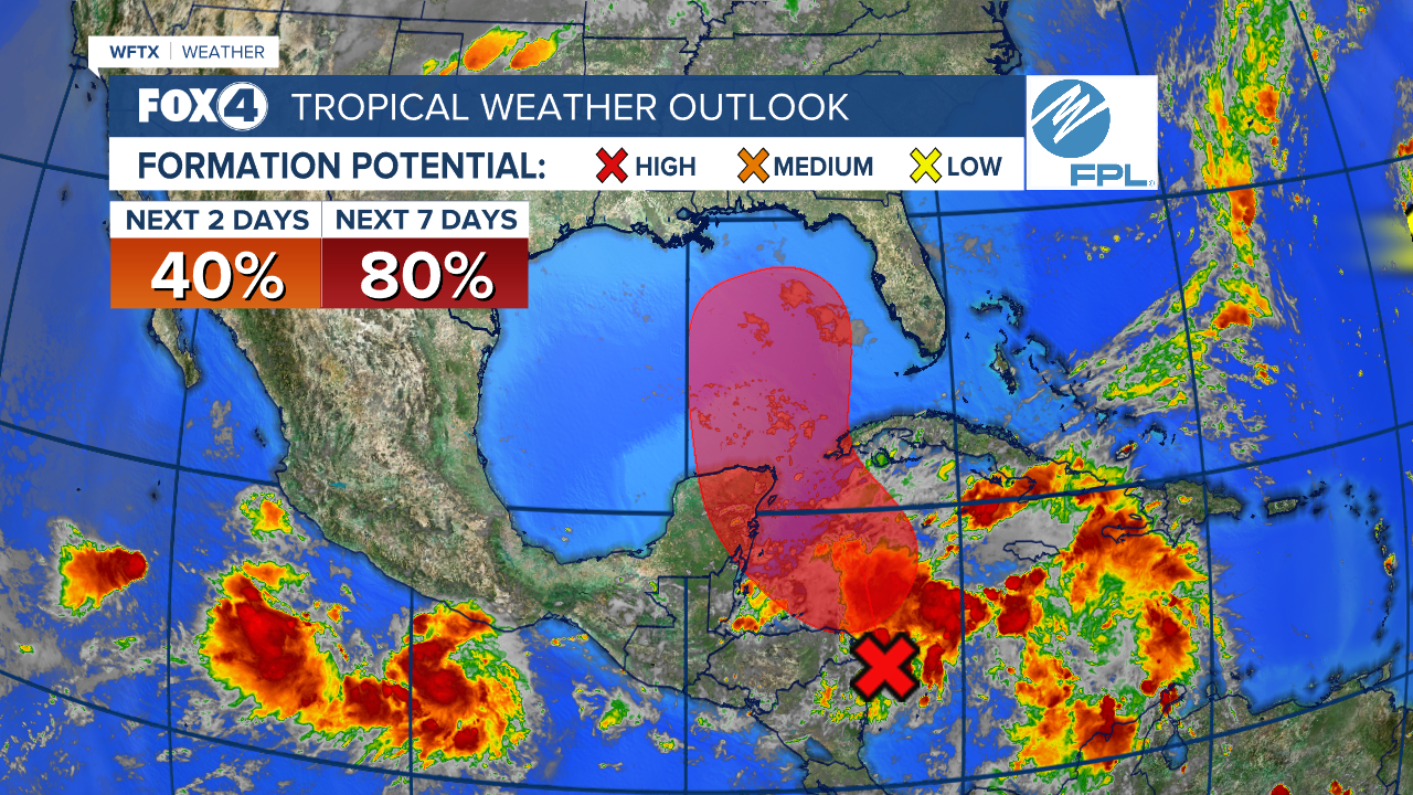
As of 8pm, the likelihood of development this week has increased to 50% chance of next 2 days and 80% over the next 7 days. We are starting to see an area of low pressure start to form along the Central America Gyre in the Caribbean Sea. Environmental conditions appear conducive for development of this disturbance, and a tropical depression or tropical storm is likely to form during the next few days while the system moves northward across the northwestern Caribbean Sea and into the southeastern Gulf of Mexico. Regardless of development, this disturbance is expected to produce heavy rains over portions of Central America during the next several days. Interests in the northwestern Caribbean, the Yucatan Peninsula of Mexico, and western Cuba should closely monitor the progress of this feature. Later this week, the system is forecast to move generally northward across the eastern Gulf of Mexico, and interests along the northern and northeastern Gulf Coast should also monitor the progress of this system.
2PM Update, Sunday, September 22, 2024:
As of 2pm, the likelihood of development this week has increased to 40% chance of next 2 days and 80% over the next 7 days. We are starting to see an area of low pressure start to form along the Central America Gyre in the Caribbean Sea. Environmental conditions appear favorable for development of this system, and a tropical depression or tropical storm is likely to form during the next few days while moving northward across the northwestern Caribbean Sea and Gulf of Mexico. Regardless of development, this disturbance is expected to produce heavy rains over portions of Central America during the next several days. Interests in the northwestern Caribbean, Yucatan Peninsula of Mexico, and western Cuba should closely monitor the progress of this feature. Later this week, the system is forecast to move generally northward across the Gulf of Mexico, and interests along the northern and northeastern Gulf Coast should also monitor the progress of this system.
WFTX
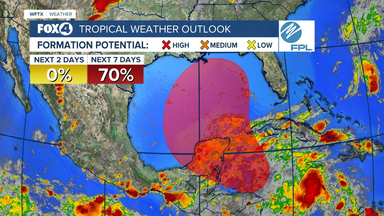
8AM Update, Sunday, September 22, 2024:
As of 8am, the likelihood of development next week has increased to 10% chance of next 2 days and 70% over the next 7 days. We are starting to see an area of low pressure start to form along the Central America Gyre in the Caribbean Sea. Environmental conditions appear favorable for gradual development of this system during the next several days. A tropical depression is likely to form while the system moves slowly northward across the northwestern Caribbean Sea and Gulf of Mexico through the end of the week. Regardless of development, this system is expected to produce heavy rains over portions of Central America during the next several days.
Gulf potential development likely next week
8PM Update, Saturday, September 21, 2024:
As of 8pm, the likelihood of development next week has increased to 70%. No development is forecast over the weekend, but a broad area of low pressure should form during the next few days over the northwestern Caribbean Sea and the adjacent portions of Central America. Thereafter, gradual development of this system is expected, and a tropical depression is likely to form as the system moves slowly northward across the northwestern Caribbean Sea and Gulf of Mexico through the end of next week. Regardless of development, this system is expected to produce heavy rains over portions of Central America during the next several days.
WFTX
8AM Update, Saturday, September 21, 2024:
As of 8am, the likelihood of development next week has remained at 60%. No development is forecast over the weekend, but early to mid next week, an area of low pressure is forecast to form in northwestern Caribbean Sea and the adjacent portions of Central America. Thereafter, gradual development of this system is possible, and a tropical depression could form as the system moves slowly to the north or northwest over the northwestern Caribbean Sea and across the Gulf of Mexico through the end of next week. Regardless of development, this system is expected to produce heavy rains over portions of Central America during the next several days.
Gulf potential development now up to 60%
8PM Update, Friday, September 20, 2024:
As of 8pm, the likelihood of development next week has increased to 60%. No development is forecast over the weekend, but early to mid next week, an area of low pressure is forecast to form over the northwestern Caribbean Sea. Once it does so, then we’ll have a much better idea of its potential path and intensity once it enters the Gulf.
5PM Update, Friday, September 20, 2024:
We are keeping a close eye on what is expected to become our next tropical depression and eventually Tropical Storm Helene in the Gulf of Mexico.
A broad area of low pressure could form by the early to middle part of next week over the northwestern Caribbean Sea. Thereafter, gradual development of this system is forecast, and a tropical depression could form as the system moves slowly to the north into the southern Gulf of Mexico.
Based upon the latest data, we are expecting the system to become “Helene” in the Gulf of Mexico next week. BUT, until the low pressure itself develops, models will not have a solid grasp on its path or intensity. (So, be very weary of any deterministic forecast models you see floating around!)
Because the low has not formed yet, potential impacts in SWFL are yet to be determined. If it’s closer to the SWFL coast, then we will feel greater impacts in terms of winds, coastal flooding and heavy rainfall late week. If the system stays in the western Gulf, we’ll see little impact here.
This system bears close monitoring, especially as it moves into the southern Gulf of Mexico.
Source link : http://www.bing.com/news/apiclick.aspx?ref=FexRss&aid=&tid=66f1e815cd934c8b9877fda999d4df4e&url=https%3A%2F%2Fwww.fox4now.com%2Fweather%2Fhurricane-center%2Feyes-on-the-gulf-helene-development-becoming-more-likely-next-week&c=13952878622210800287&mkt=en-us
Author :
Publish date : 2024-09-22 10:13:00
Copyright for syndicated content belongs to the linked Source.


