

What are 2024 hurricane names? When is Atlantic hurricane season?
The Atlantic hurricane season runs from June 1 through Nov. 30. Here is the list of names for 2024, as set by the World Meteorological Organization.
(This story was updated to add new information.)
As the remnants of Gordon hang on in the Central Atlantic, an area of low pressure near the Leeward Islands — known as AL96 — is producing disorganized shower and thunderstorm activity. Tropical advisories show activity that could potentially form into a system, according to the National Hurricane Center in Miami.
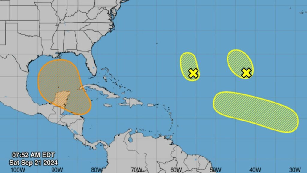
Here’s what’s brewing in the tropics as of Saturday, Sept. 21:
Central Subtropical Atlantic (Remnants of Gordon):
Strong upper-level winds continue to keep showers and thunderstorms displaced away from the center of an area of low pressure (the remnants of Gordon) more than 1,000 miles southwest of the Azores. Significant development of this system is not expected while it moves slowly northwestward over the central subtropical Atlantic during the next couple of days.
Formation chance through 48 hours is low at 10 percent. Formation chance through 7 days is low at 10 percent.
➤ Weather alerts via text: Sign up to get updates about current storms and weather events by location
Central Subtropical Atlantic (AL96):
An area of low pressure located about 700 miles northeast of the northern Leeward Islands is producing some disorganized shower and thunderstorm activity. Environmental conditions do not appear conducive for significant development of this system during the next couple of days while it drifts northwestward and then northward at about 5 mph over the central or western subtropical Atlantic.
Formation chance through 48 hours is low at 10 percent. Formation chance through 7 days is low at 10 percent.
Northwestern Caribbean Sea and Gulf of Mexico:
A broad area of low pressure is likely to form by the early to middle part of next week over the northwestern Caribbean Sea and the adjacent portions of Central America. Thereafter, gradual development of this system is possible, and a tropical depression could form as the system moves slowly to the north or northwest over the northwestern Caribbean Sea and across the Gulf of Mexico through the end of next week. Regardless of development, this system is expected to produce heavy rains over portions of Central America during the next several days.
Formation chance through 48 hours is low, near 0 percent. Formation chance through 7 days is medium at 60 percent.
Eastern and Central Tropical Atlantic:
A tropical wave is expected to move westward from the coast of Africa on Sunday or Monday. Gradual development of this system is possible next week as it moves west-northwestward over the eastern and central tropical Atlantic.
Formation chance through 48 hours is low near 0 percent. Formation chance through 7 days is low at 30 percent.
Retired hurricane names: These will never, ever be used again. Is your name on the list?
National Hurricane Center also tracking 3 tropical waves in the Atlantic
The National Hurricane Center in Miami issued a tropical weather outlook. Here is the advisory as of 8 a.m. EST Saturday, Sept. 21:
Gulf of Mexico:
Convection associated with a weak surface trough over the Florida Straits has dissipated overnight, with high pressure of 1012 mb centered along the Mississippi coast dominating Gulf weather and leading to dry conditions. Gentle east winds and seas of 1 to 3 feet prevail.
For the forecast, high pressure will dominate into early next week. A broad area of low pressure may form by the early to middle portions of next week over the NW Caribbean and adjacent portions of Central America. Thereafter, gradual development of this system is possible, and a tropical depression could form as the system moves slowly to the north or northwest over the northwestern Caribbean Sea and into the southern Gulf of Mexico through the end of next week. There is a medium chance of tropical cyclone formation in the next seven days. Regardless of development, winds and seas will start increasing across the SE Gulf early next week.
Caribbean Sea:
Gentle to moderate east to southeast winds and seas at 3 to 5 feet are present across the south- central and southeastern basin. Gentle east winds and seas of 2 to 4 feet prevail elsewhere in the Caribbean Sea.
For the forecast, moderate to fresh winds and moderate seas are expected across the east and central Caribbean through tonight.
Looking ahead, a broad area of low pressure could form by the early to middle part of next week over the northwestern Caribbean Sea and adjacent parts of Central America. Thereafter, gradual development of this system is possible, and a tropical depression could form as the system moves slowly to the north or northwest over the northwestern Caribbean Sea and into the southern Gulf of Mexico through the end of next week. There is a medium chance of tropical cyclone formation in the next seven days.
Atlantic Ocean:
Low pressure of 1008 mb centered near 25N55W is inducing scattered moderate convection within about 90 nm of the center in the NE quadrant, along with fresh winds and seas to 7 feet within about 180 nm of the center in the NE semicircle. Environmental conditions do not appear conducive for significant development of this system during the next couple of days while it drifts northwestward over the central or western subtropical Atlantic.
To the east, another low pressure of 1005 mb, the remnants of Tropical Storm Gordon, is centered near 26N42W. This low is inducing scattered moderate convection E of the center, from 23N to 30N, extending E to 32W. Within this area of scattered showers and thunderstorm, fresh to locally strong winds and seas to 8 feet prevail. The precipitation is being sheared away from the center by strong upper level winds, and these winds are forecast to prevent significant development of this low as it meanders over the central subtropical Atlantic during the next couple days.
Elsewhere, a surface trough stretches from around 31N73W, acrossthe NW Bahamas, and into the Florida Straits. This trough is leading to scattered moderate convection over the central and NW Bahamas. Gentle to moderate NE winds are noted NW of this trough axis. Other areas of central to moderate winds are noted within about 150 nm of the South American coast as well as in the vicinity of the Cabo Verde Islands, extending E to the coast of Africa. Elsewhere in the basin, winds are light to gentle. Seas aside from the areas already mentioned average 3 to 6 feet.
For the forecast W of 55W, a weak cold front will exit the southeast coast of the US tonight and slowly move across the waters north of 25N into Monday night.
What’s the forecast for Lakeland and Polk County?
The National Weather Service in Tampa predicts fairly quiet conditions in Polk County through Monday, with occasional isolated showers and thunderstorms moving through the area.
Saturday: Isolated showers and thunderstorms after 4 p.m. Sunny, with a high near 90. Heat index values as high as 98. Northeast wind 7 to 9 mph. Chance of precipitation is 10%.
Saturday night: Mostly clear, with a low around 72. Northeast wind 3 to 7 mph.
Sunday: Isolated showers and thunderstorms after 2 p.m. Sunny, with a high near 91. Heat index values as high as 101. Northeast wind 5 to 8 mph. Chance of precipitation is 20%.
Sunday Night: Mostly clear, with a low around 73. East northeast wind 5 to 8 mph.
Monday: Sunny, with a high near 92. East northeast wind 5 to 10 mph.
Monday Night: Mostly clear, with a low around 73. East wind 5 to 10 mph.
Weather radar: Will it rain in Gainesville, Jacksonville, St. Augustine, Daytona Beach, Florida?
Shown is the National Weather Service radar for Jacksonville area, which shows conditions in real-time for parts of North Florida. The current date and time show up on the bottom right of this radar embed; otherwise, you may need to clear your cache.
Weather radar: Will it rain in Melbourne, Orlando, Lakeland, Tampa, Sarasota, Fort Myers, Fort Pierce, Florida, today?
Shown is the National Weather Service-Melbourne radar, which shows conditions in real-time for the Space Coast and other parts of Florida. The current date and time show up on the bottom right of this radar embed; otherwise, you may need to clear your cache.
Weather radar: Will it rain in West Palm Beach, Fort Lauderdale, Naples, Miami, Florida, today?
Shown is the National Weather Service radar for West Palm Beach, which shows conditions in real-time for parts of South Florida and the Florida Keys. The current date and time show up on the bottom right of this radar embed; otherwise, you may need to clear your cache.
Weather radar: Will we get showers, thunderstorms, rain in Florida today?
Shown is the National Weather Service radar for the Southeast United States, which shows conditions in real-time. The current date and time show up on the bottom right of this radar embed; otherwise, you may need to clear your cache.
Watches, warnings issued for Florida, USStay informed. Get weather alerts via textExcessive rainfall forecast
According to the National Hurricane Center in Miami, these are the list of names for the 2024 Atlantic hurricane season:
AlbertoBerylChrisDebbyErnestoFrancineGordonHeleneIsaacJoyceKirkLeslieMiltonNadineOscarPattyRafaelSaraTonyValerieWilliamWhat’s next?
We will continue to update our tropical weather coverage daily. Download your local site’s app to ensure you’re always connected to the news. And look for our special subscription offers here.
Contributing: Cheryl McCloud, USA TODAY Network-Florida
Source link : http://www.bing.com/news/apiclick.aspx?ref=FexRss&aid=&tid=66eee4646b354955b057a2074ad8bb6a&url=https%3A%2F%2Fwww.theledger.com%2Fstory%2Fweather%2Fhurricane%2F2024%2F09%2F21%2Fcaribbean-system-could-develop-next-week-polk-county-forecast%2F75324400007%2F&c=7552555966120627657&mkt=en-us
Author :
Publish date : 2024-09-21 03:18:00
Copyright for syndicated content belongs to the linked Source.