
![]()

Hurricane Milton opened a new pass on the south end of Manasota Key
The new channel is at Stump Pass Beach State Park, just north of Stump Pass on Manasota Key
Here is the latest update on Hurricane Oscar.
Oscar is considered a Category 1 storm based on its sustained wind speed. As of the National Hurricane Center’s 5 p.m. EDT advisory, Oscar is very close to making landfall this afternoon along the northern coast of eastern Cuba.
The NHC forecast does not show any intensification after it emerges back offshore.
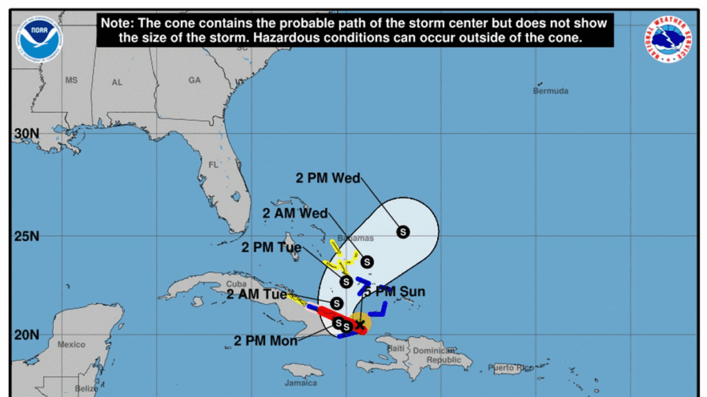
Cone of uncertainty: See the latest graphic from the NHC
Satellite images: See latest satellite image from NOAA, for a clearer picture of the storm’s size
According to the NHC, the storm’s center was located 20 miles north-northwest of the eastern tip of Cuba, and 60 miles east-northeast of Guantanamo as of 5 p.m. EDT Sunday.
The latest NHC advisory says Oscar is moving toward the west-southwest at 6 mph.
On the forecast track, the center of Oscar is expected to make landfall along the northern coast of eastern Cuba shortly. The system is then expected to move across eastern Cuba tonight and Monday. Oscar is then forecast to begin moving a bit faster to the northeast across the central Bahamas on Tuesday.
Maximum sustained winds are near 80 mph with higher gusts. After Oscar makes landfall, significant weakening is expected, but Oscar could still be a tropical storm when it moves north of Cuba late Monday and then moves across the central Bahamas on Tuesday.
Expected impacts from Hurricane Oscar
The advisory warns of the following dangers:
WIND: Hurricane conditions are expected in the warning area in Cuba beginning shortly and continuing through tonight. Tropical storm conditions are expected for a few more hours in the warning area for the southeastern Bahamas and for tonight and Monday in the warning area in Cuba, and are possible in the watch area of Cuba tonight into Monday. Tropical storm conditions are possible in the watch area in the central Bahamas on Tuesday.
RAINFALL: Through Wednesday morning, rainfall amounts of 6 to 12 inches with isolated amounts of 18 inches are expected across eastern Cuba. Across the southeastern Bahamas, 3 to 5 inches are expected, with isolated amounts around 8 inches. Across the Turks and Caicos, an additional 2 to 4 inches of rain is expected through Wednesday morning. For a complete depiction of forecast rainfall associated with Hurricane Oscar, please see the National Weather Service Storm Total Rainfall Graphic, available at hurricanes.gov/graphics_at1.shtml?rainqpf.
STORM SURGE: Water levels of 1 to 3 ft above normal tide levels are expected along the north shore of Cuba in areas of onshore winds. Near the coast, the surge will be accompanied by large and destructive waves.
Where is Hurricane Oscar?
Here are the latest details on Oscar, according to the NHC’s 5 p.m. EDT advisory.
Location: 20 miles north-northwest of the eastern tip of Cuba; 60 miles east-northeast of Guantanamo, CubaMaximum sustained winds: 80 mphMovement: West-southwest at 6 mph
Oscar’s estimated minimum central pressure is 986 millibars.
Anything greater than 979 MB is one indicator a storm could cause minimal damage. According to the NHC, the minimum central pressure of a storm is not necessarily a hazard, but it could indicate whether a storm will intensify in the future. Strengthening usually follows a drop in pressure, and a weakening usually follows an increase in pressure.
What does the cone of uncertainty represent?
The cone of uncertainty, posted by the NHC, shows some possible paths of the storm’s center. As you monitor the forecast, keep in mind that the impact of Oscar may be felt well outside the cone – and that storm tracks go outside of the cone about a third of the time.
Watches, warnings
SUMMARY OF WATCHES AND WARNINGS IN EFFECT:
A Hurricane Warning is in effect for… * Southeastern Bahamas * North coast of the Cuban Provinces of Holguin and Guantanamo to Punta MaisiA Hurricane Watch is in effect for… * North coast of the Cuban Province of Las TunasA Tropical Storm Warning is in effect for… * Turks and Caicos Islands * South coast of Cuban Province of Guantanamo * North coast of the Cuban Province of Las TunasA Tropical Storm Watch is in effect for… * North coast of the Cuban Province of CamagueyA Hurricane Warning means that hurricane conditions are expected somewhere within the warning area. Preparations to protect life and property should be rushed to completion.
A Hurricane Watch means that hurricane conditions are possible within the watch area. A watch is typically issued 48 hours before the anticipated first occurrence of tropical-storm-force winds, conditions that make outside preparations difficult or dangerous.
A Tropical Storm Warning means that tropical storm conditions are expected somewhere within the warning area within 36 hours.
A Tropical Storm Watch means that tropical storm conditions are possible within the watch area, generally within 48 hours.
Interests in the central Bahamas should monitor the progress of Oscar. Tropical storm watches could be required for this area later today.For storm information specific to your area, please monitor products issued by your national meteorological service.
Spaghetti models: Track Oscar here
This auto-updated graphic shows how various spaghetti models are tracking Hurricane Oscar:
If the storm tracker is not loading, click here.
Special note about spaghetti models: Illustrations include an array of forecast tools and models, and not all are created equal. The hurricane center uses only the top four or five highest-performing models to help make its forecasts.
Helpful hurricane resources and links
(This story has been updated to add new information.)
Source link : https://okcthunderwire.usatoday.com/story/weather/hurricane/2024/10/20/hurricane-oscar-track-path-spaghetti-models/75762714007/
Author :
Publish date : 2024-10-20 09:28:00
Copyright for syndicated content belongs to the linked Source.