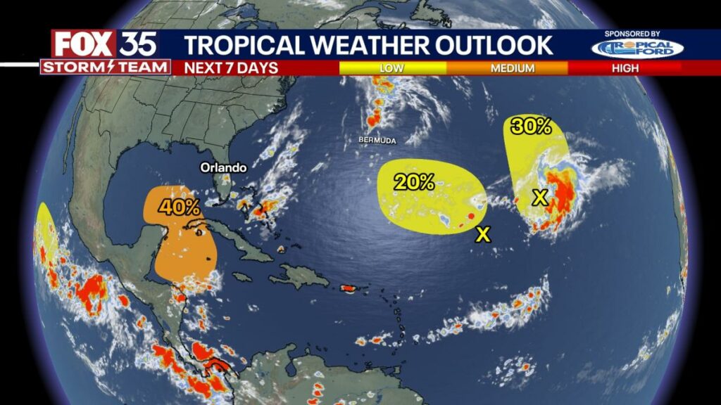
The odds of a tropical disturbance developing in the northwestern Caribbean Sea and southeastern Gulf of Mexico have increased, according to the National Hurricane Center (NHC).
The NHC said the system could become an area of low pressure by this weekend or early next week over the western and northwestern Caribbean Sea. Gradual development is possible, and a tropical depression could form as the system moves over the northwestern Caribbean Sea into the southeastern Gulf of Mexico during the middle of next week, officials said.
The system has a medium chance – 40% – of developing over the next seven days.
Nearly every hurricane season, forecasters monitor a broad area of low pressure in the western Caribbean Sea and the eastern Pacific Ocean, known as a gyre. Due to its location, the circulation is known as the Central American Gyre (CAG) and usually occurs during the rainy season from May through November.
Impacts expand outwards several hundred miles and lead to threats of torrential rainfall, flooding, and mudslides for more than a dozen countries centered in and around Central America.
“Simply put, there appear to be two clear scenarios later next week for our hypothetical tropical system forming between and Cuba,” explained FOX 35 Storm Team Meteorologist Noah Bergren. “A stronger, farther south cold front over the central-eastern U.S. probably pushes the said system into Florida, possibly a tad faster with less time to intensify over water. Another scenario is a much weaker cold front farther north over the Northeast, and/or a stronger high over the Bahamas. Then, the system would likely push west of Florida.”
Bergen said that the storm could be much stronger due to a slower passage over extremely warm water in the Gulf of Mexico.
“Models will do this. Models will do that. They will bounce around. After all, they are models, and we are meteorologists, not ‘model-ologists.’ So let’s not get too worked up about any one computer model run,” Bergen added.
A strike to Florida is equally possible as anywhere else on the Gulf Coast from a tropical system late next week. For now, storm or no storm in your town, it is advised that you review your hurricane plan and supplies, and then we sit back and wait.
Could the remnants of Tropical Storm Gordon re-develop?
The NHC continues to watch the remnants of former Tropical Storm Gordon, which could re-form into a tropical depression or storm in the coming days. However, forecasters note that “environmental conditions appear only marginally conducive for additional development.”
This disturbance may interact with another area of low pressure located to its west in the central and western subtropical Atlantic as it moves northward at 5 to 10 mph over the next couple of days. That system, which the NHC dubbed as Invest 96L on Thursday evening, has a low (20%) chance of development over the next seven days, while the remnants of Gordon hold a 30% chance for formation.
Track live when storms move across your area using the FOX 35 Storm Storm Tracker Radar below.
More radar maps from FOX 35 Storm Tracker RadarStay connected with FOX 35
Source link : http://www.bing.com/news/apiclick.aspx?ref=FexRss&aid=&tid=66ecfb2338f142cdb536de13bec2de41&url=https%3A%2F%2Fwww.aol.com%2Fnews%2Fodds-increase-development-disturbance-caribbean-103303757.html&c=3025703761369509876&mkt=en-us
Author :
Publish date : 2024-09-19 02:33:00
Copyright for syndicated content belongs to the linked Source.
