4th tropical disturbance forms in the Atlantic
A fourth tropical disturbance formed in the Atlantic Ocean on Saturday, as the 2024 Atlantic hurricane season hits peak season.
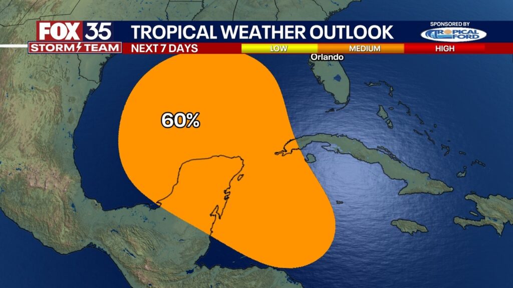
ORLANDO, Fl – A tropical disturbance in the Caribbean Sea could become a tropical depression next week as it approaches the Gulf of Mexico, according to the National Hurricane Center.
The tropical disturbance now has a medium chance of development, 60%, over the next seven days, the NHC said. Regardless of when it forms, it is expected to bring heavy rain to Central America. It is still too early to tell what impact it will have on the U.S. Gulf Coast, including Florida, if any.
According to the NHC, a tropical depression could form as the system moves slowly to the north or northwest over the northwestern Caribbean Sea and across the Gulf of Mexico through the end of next week.
It is one of four disturbances being monitored by the National Hurricane Center. More details on that below.
Is the potential tropical disturbance headed toward Florida?
It’s still too early to know exactly where this potential system will go – and if it will ultimately impact Florida. As of right now, it is not yet a tropical depression, tropical storm, or even a hurricane.
However, regardless of where and when it develops, rain is likely for parts of Florida. How much? Unclear at this moment. It is a system that the National Hurricane Center and the FOX 35 Storm Team are monitoring.
Currently, two of the main future forecast models – the GFS and EURO models, computers that use data to predict a system’s possible track – show two potentially different scenarios.
The first scenario comes from the Global Forecast System Model (GFS) and is showing a strong cold front over the central/eastern U.S. This could push the tropical system towards Florida, according to the FOX 35 Storm Team.
The second scenario, suggested by the EURO model, would be a much weaker cold front and/or stronger high over the Bahamas and Florida will almost act as a shield protecting the state. This would then in turn push the storm west towards Mississippi, Alabama and Texas.
As with all models, the data and projections could change hour by hour.
If the system develops into a tropical depression and continues to develop, it could end up being Tropical Storm Helene.
There are three other tropical disturbances being monitored in the Atlantic, all with low chances of further development over the next seven days, including the remnants of Tropical Storm Gordon.
RELATED: Fourth tropical disturbance pops up in Atlantic; any impacts to Florida?
So far, no concerns with those three about potential impacts to Florida.
STAY CONNECTED WITH FOX 35 ORLANDO:
Source link : http://www.bing.com/news/apiclick.aspx?ref=FexRss&aid=&tid=66ef2b181cce48f58dac0b8a3177c23a&url=https%3A%2F%2Fwww.fox35orlando.com%2Fnews%2Ftropical-depression-likely-gulf-mexico-next-week-national-hurricane-center&c=6069360091859425173&mkt=en-us
Author :
Publish date : 2024-09-21 09:03:00
Copyright for syndicated content belongs to the linked Source.
