
Tropical Storm Milton formed in the Gulf of Mexico Saturday afternoon and is now expected to rapidly strengthen into a major hurricane before making landfall on Florida’s west coast.
Moisture ahead of the “intense hurricane” will begin to impact Florida late this weekend before Milton arrives next week, bringing torrential downpours and damaging winds, the National Hurricane Center said.
“Regardless of the exact details of the intensity forecast, an intense hurricane with multiple life-threatening hazards is likely to affect the west coast of the Florida Peninsula next week,” forecasters said Saturday. Forecasters warned residents from the Panhandle to the Keys to watch the progress of the storm closely.
Late Saturday, Gov. Ron DeSantis declared a state of emergency for 35 counties in advance of the storm, including Palm Beach, Broward and Miami-Dade counties. The others are Brevard, Charlotte, Citrus, Collier, DeSoto, Flagler, Glades, Hardee, Hendry, Hernando, Highlands, Hillsborough, Indian River, Lake, Lee, Manatee, Marion, Martin, Monroe, Okeechohee, Orange, Osceola, Pasco, Pinellas, Polk, Putnam, Sarasota, Seminole, St. Johns, St. Lucie, Sumter, and Volusia counties.
Since many of those counties are still recovering from Hurricane Helene, DeSantis asked the Florida Division of Emergency Management and the Florida Department of Transportation to coordinate all available resources and personnel to supplement local communities as they expedite debris removal.
Though no coastal watches or warnings were in effect on Saturday, the hurricane center said the Florida Peninsula, the Florida Keys, Mexico’s Yucatan peninsula and the northwestern Bahamas should monitor the system’s progress.
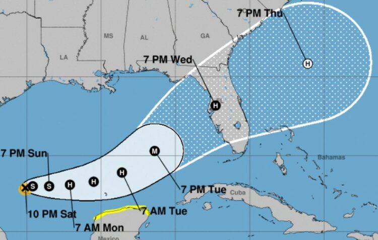
As of 11 p.m., Tropical Storm Milton was located about 860 miles west-southwest of Tampa, with its forward motion bumping up from 3 mph at 5 p.m. to 5 mph, moving north-northeast with maximum sustained winds of 45 mph, up from 5 p.m.’s 40 mph. It is forecast to become a hurricane by Sunday night, and then a major hurricane as it moves across the central and eastern Gulf of Mexico.
Tropical-storm-force winds extend outward up to 35 miles from the center, and a tropical storm watch is in effect for Celestun to Cancun, Mexico.
Currently, the forecast calls for Milton to become a hurricane in the next 36 hours and a major hurricane in the next 72 hours.
Here’s the latest forecast track.
By Tuesday, Milton is expected to speed up, and it should reach the west coast of the Florida peninsula by midweek. Meanwhile, the moisture ahead of Milton is likely to bring heavy and prolonged rainfall to South Florida starting late Sunday through Monday.
Conditions will allow for “steady to rapid strengthening over the next few days,” forecasters said. “The intensification is likely to be slower during the next 12 to 24 hours until an inner core can become established, but after that time a faster rate of strengthening is anticipated.”
Richard Boggs loads up sandbags at Floyd Hull Stadium in Fort Lauderdale on Saturday. (Mike Stocker/South Florida Sun Sentinel)
Various forecast models that the hurricane center is using for tracking the system — known as “spaghetti models” — are showing the path hitting Florida’s west coast and moving east across the peninsula through Central Florida.
A stronger, slower storm would likely hit further north; a faster, weaker storm would hit further south, the models show.
“Regardless of tropical or subtropical development, locally heavy rains could occur … over much of Florida late this weekend through the middle of next week,” National Hurricane Center forecasters said. “In addition, increasing winds and building seas are also forecast.”
The weather pattern is complex, consisting of three waves: the remnants of a tropical Pacific system moving east over southern Mexico and Central America, a wave in the western Caribbean Sea off the Yucatan Peninsula, and a building low-pressure system in the Bay of Campeche west of the Yucatan.
The system is carrying a lot of moisture, and will bring heavy rainfall to parts of the Florida already saturated by Hurricane Helene. As much as a foot of rain could fall in some areas.
Currently, clouds and showers/thunderstorms over portions of South Florida are associated with a broad area of low pressure area not tied to Milton. Heavy rainfall and flooding is expected across South Florida through early next week. A Flood Watch is in effect for the entire area from Sunday morning to Thursday morning.
The projected impact of Milton to the South Florida region is still being assessed, but is generally expected to be late Tuesday through Wednesday.
Other tropical systems
Far in the Atlantic, Hurricane Leslie formed on Saturday and Hurricane Kirk continued moving northwest as a Category 3 major hurricane. Neither is a threat to land.
Leslie, located 855 miles west of Africa’s southernmost Cabo Verde Island, had a maximum sustained wind speed of 80 mph and was moving northwest at 9 mph as of 11 p.m. Saturday. In the five-day track, forecasters are projecting the storm to turn to the northwest, away from the Caribbean, and increase in forward speed. Leslie may begin weakening sometime in the next one or two days.
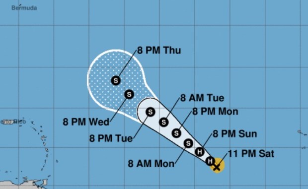

“The ridge will continue to steer Leslie the next several days with a turn more northwestward, with an increase in forward speed by the middle of the forecast period,” forecasters said.
Meanwhile, Hurricane Kirk degraded to a weak Category 3 hurricane after its maximum sustained winds dropped to 115 mph Saturday night. Though Kirk is not near land, it is forecast to bring large swells to the U.S. East Coast by Sunday, according to the National Hurricane Center.
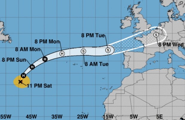

At 11 p.m. Saturday, Kirk was located about 1,345 miles west-southwest of the Azores and was moving north at 20 mph.
Long-range forecasts show Kirk arcing north and west toward Europe.
Finally, a tropical wave is expected to move off the coast of Africa on Monday or Tuesday. It could develop as it moves westward or west-northwestward over the eastern tropical Atlantic. It had a 30% chance of forming in the next seven days as of 8 p.m. Saturday.
The next named storm will be Nadine.
Information from the Associated Press was used in this report.
Forecasts for Hurricane Helene’s path were uncannily accurate. Here’s why.
Originally Published: October 5, 2024 at 8:15 a.m.
Source link : http://www.bing.com/news/apiclick.aspx?ref=FexRss&aid=&tid=67020b85a82c4dcd8953a4065665a97e&url=https%3A%2F%2Fwww.bostonherald.com%2F2024%2F10%2F05%2Fflorida-tropical-depression-storm-milton%2F&c=7938579136168512124&mkt=en-us
Author :
Publish date : 2024-10-05 05:15:00
Copyright for syndicated content belongs to the linked Source.