

Sunday features a sunny morning with a few showers and storms developing in spots during the afternoon as autumn arrives in South Florida. Minor flooding is possible at high tides along both coasts and the Keys on Sunday. Expect a moderate risk of dangerous rip currents along the Palm Beach County coast. Highs on Sunday will be in the low 90s.
Monday will bring mostly sunny skies and some mainly afternoon and early evening storms to the East Coast metro area. The Gulf Coast will see lots of sun in the morning, but showers and storms will be back in the afternoon. Look for plenty of clouds and periods of showers in the Keys. Monday’s highs will be near 90 degrees in the East Coast metro area and the Keys and in the low 90s along the Gulf Coast.
Tuesday will feature a mix of sun and clouds with periods of showers and storms in the east coast metro area. The Gulf Coast will be sunny during the morning, but showers and storms will develop in the afternoon and linger into the evening. The Keys will be on the cloudy side with periods of showers. Tuesday’s highs will be near 90 degrees in the East Coast metro area and the Keys and in the low 90s along the Gulf Coast.
Wednesday will be mostly sunny with periods of showers and storms on the mainland, while the Keys will see lots of clouds and some showers and storms. Wednesday’s highs will be near 90 degrees.


Thursday’s forecast calls for clouds, showers, and storms on a brisk breeze as tropical moisture moves in. Highs on Thursday will be in the upper 80s.
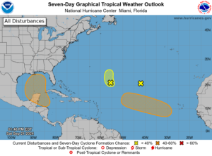

Elsewhere, the remnants of Gordon are not expected to redevelop. The low that’s now about 700 miles east of Bermuda is encountering dry air and is also not expected to develop. But a wave that is emerging from the African coast has a medium chance of becoming a depression this week as it moves to the west-northwest — so we’ll keep an eye on it..
Disclaimer
The information contained in South Florida Reporter is for general information purposes only.
The South Florida Reporter assumes no responsibility for errors or omissions in the contents of the Service.
In no event shall the South Florida Reporter be liable for any special, direct, indirect, consequential, or incidental damages or any damages whatsoever, whether in an action of contract, negligence or other tort, arising out of or in connection with the use of the Service or the contents of the Service. The Company reserves the right to make additions, deletions, or modifications to the contents of the Service at any time without prior notice.
The Company does not warrant that the Service is free of viruses or other harmful components
Source link : http://www.bing.com/news/apiclick.aspx?ref=FexRss&aid=&tid=66efa7f48dbc4a1f995e4b20ffd89757&url=https%3A%2F%2Fsouthfloridareporter.com%2Fautumn-sun-and-a-few-storms-here-still-watching-the-tropics%2F&c=5381581022749572787&mkt=en-us
Author :
Publish date : 2024-09-21 18:10:00
Copyright for syndicated content belongs to the linked Source.