COASTAL FLOOD ADVISORY IN effect until 5 PM Sunday
The potential impact includes flooding of lots, parks, and roads with only isolated road closures expected.
Do not drive around barricades or through water of unknown depth. Take the necessary actions to protect flood-prone property.
Low temperatures for this evening (WJXT TV 4)
TONIGHT
This is a near-perfect weekend for the outdoors. Average temperatures for this time of year are in the low 70s and highs in the mid to upper 80s. We are shifting into the Floridian style of fall.
Temperatures will drop into the low 70s tonight with winds from the north and northeast. Breezy then shifting to calm before midnight. High humidity levels will remain but no rain is possible Saturday evening. Skies will remain clear allowing for a perfect outdoor evening.
RIP CURRENT RISK
Rip current risks remain high for the weekend due to winds from the east and northeast. Swim near a lifeguard. If caught in a rip current, relax and float. Don`t swim against the current. If able, swim in a direction following the shoreline. If unable to escape, face the shore and call or wave for help.
Rip Current Risk remain High through weekend (WJXT TV 4)Current River Levels range from normal to minor flooding (WJXT TV 4)
TRACKING THE TROPICS
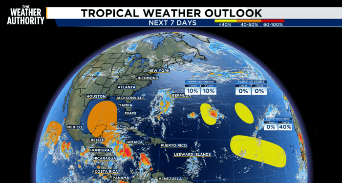
There are currently four disturbances from the Gulf to the Atlantic to watch:
Central Subtropical Atlantic (Remnants of Gordon): Formation chance through 48 hours…low…near 0 percent. * Formation chance through 7 days…low…near 0 percent.
Central Subtropical Atlantic (AL96): An area of low pressure located about 700 miles southeast of Bermuda continues to produce a small cluster of showers and thunderstorms northeast of its center. Formation chance through 48 hours…low…10 percent. * Formation chance through 7 days…low…10 percent.
Northwestern Caribbean Sea and Gulf of Mexico: A broad area of low pressure is likely to form by the early to middle part of next week over the northwestern Caribbean Sea and the adjacent portions of Central America. Formation chance through 48 hours…low…near 0 percent. * Formation chance through 7 days…medium…60 percent.
Eastern and Central Tropical Atlantic: A tropical wave is expected to move westward from the coast of Africa on Sunday or Monday. Formation chance through 48 hours…low…near 0 percent. * Formation chance through 7 days…medium…40 percent.
Four disturbances from the Gulf to the Tropics (WJXT TV 4)EURO versus GFS Model for storm prediction (WJXT TV 4)EURO versus GFS Model for storm prediction (WJXT TV 4)EURO versus GFS Model for storm prediction (WJXT TV 4)
Copyright 2024 by WJXT News4JAX – All rights reserved.
Source link : http://www.bing.com/news/apiclick.aspx?ref=FexRss&aid=&tid=66ef34cc577446acbb6ed5da6fe0a511&url=https%3A%2F%2Fwww.news4jax.com%2Fweather%2F2024%2F09%2F21%2Flocal-dangerous-rip-currents-multiple-disturbances-in-the-tropics%2F&c=13067903832264513847&mkt=en-us
Author :
Publish date : 2024-09-21 05:57:00
Copyright for syndicated content belongs to the linked Source.


