
One of two tropical features that AccuWeather meteorologists have been monitoring before mid-October will threaten to bring torrential rain and gusty winds to many of the islands in the northern Caribbean from late this week to next week. The second tropical feature will unload torrential rainfall in part of America late this week and has the potential to ramp up right before making landfall.
Because the area of showers and thunderstorms is likely to continue to organize and strengthen, AccuWeather meteorologists have dubbed it a tropical rainstorm to raise public awareness and help people plan ahead.
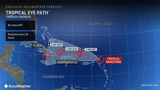
“Initially, the rainstorm will glide along on a trajectory that takes the core just to the north of the Leeward Islands,” AccuWeather Lead Hurricane Expert Alex DaSilva said, “But over time, a more southward drift is most likely with some wiggle room ranging from a more west-northwest to a southwest track.”
The longer the system stays north of the islands, the higher the chance for it to strengthen.

“It is possible the rainstorm goes on to become the next depression and named storm of the 2024 Atlantic season,” DaSilva said.
The next name on the list of tropical storms for 2024 is Nadine.
The long-term possibilities of this tropical rainstorm include a path more to the northwest into the southern Bahamas, but it is more likely to take a southwesterly track over the larger islands of Hispaniola and Cuba.
GET THE FREE ACCUWEATHER APP
“From later this weekend to early next week, either the feature will encounter increasingly hostile breezes (wind shear) to the north or the mountainous terrain of the Greater Antilles to the south,” DaSilva said, “Either would likely lead to a loss of wind intensity and could even totally break up the system.”
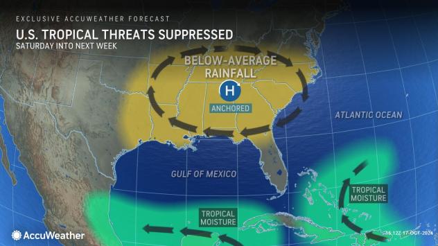
The atmosphere would have to change dramatically for the storm to approach Florida. Stiff east-northeast breezes creating the strong wind shear would have to subside, and a storm high in the atmosphere over the Bahamas would have to dissolve or move away.
The winds will create local problems for Florida in the form of rough surf, beach erosion and coastal flooding on the Atlantic side of the peninsula.
People should not focus on just where the center of the storm will track.
As the rainstorm grows in size and potentially evolves into a depression or tropical storm, bands of rain and gusty winds will expand outward from the center.
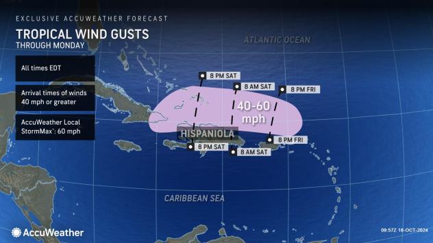
Even a strengthening tropical storm passing to the north of the Leeward Islands, as well as the United States and British Virgin Islands and Puerto Rico, is likely to create locally torrential downpours and damaging wind gusts in squalls. Surf and offshore seas will build in the vicinity of the storm.
Farther west, any direct or indirect encounter with the mountainous terrain from Puerto Rico to Hispaniola and Cuba can lead to damaging flash flooding and mudslides.
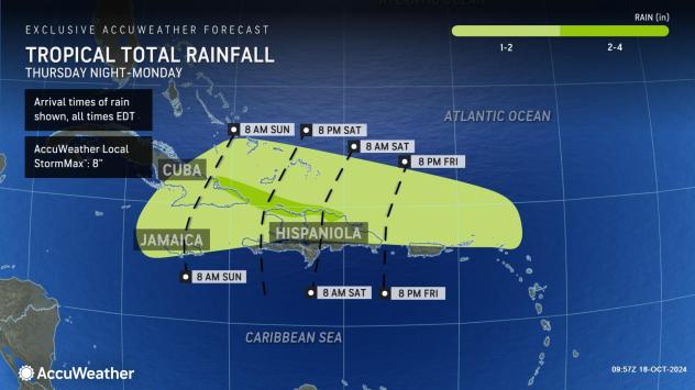
Should the storm take a more southern route, survive the trip across Hispaniola and/or Cuba and reach the northern Caribbean directly, there is a chance it will regain intensity over the very warm waters in the region. However, that would not be until later next week.
The rainstorm over the northern Caribbean could have competition for gathering the next name on the list of tropical storms, which is Nadine.
A slow-growing area of showers and thunderstorms in the western Caribbean has a chance of evolving into a tropical depression or storm before pushing into Central America late this week.
AccuWeather meteorologists have been closely monitoring this feature since last week and have declared it a tropical rainstorm to raise public awareness.
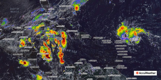

This image, captured on Thursday morning, Oct. 17, 2024, is focused on the Caribbean Sea. A tropical rainstorm was evident (right of center) just northeast of the Caribbean, and a large area of showers and thunderstorms continued to gather (left of center) over the western Caribbean. (AccuWeather Enhanced RealVue™ Satellite)
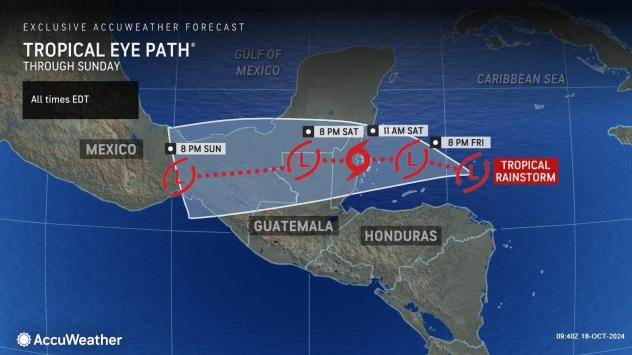
There has been a considerable uptick in thunderstorm activity in the western Caribbean, and there are more signs that this feature can strengthen into a tropical depression or storm, bringing considerable impacts in terms of heavy rain and gusty winds to Belize, southeasternmost Mexico, northern Honduras and northeastern Guatemala from Friday to this weekend.
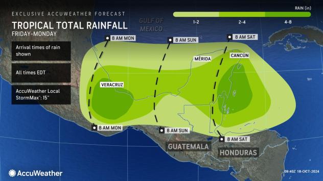
Enough rain may pour down to trigger dangerous flash flooding and mudslides, especially in the mountainous terrain of Mexico.
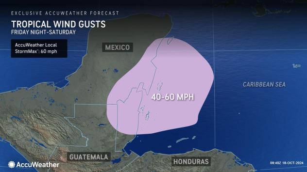
The storm may organize at the last minute before moving onshore Saturday. Tropical-storm-force wind gusts may be enough to trigger power outages in Belize and along the eastern coast of the Yucatan Peninsula.
Following Nadine, Oscar is the next name on the list for 2024.
Want next-level safety, ad-free? Unlock advanced, hyperlocal severe weather alerts when you subscribe to Premium+ on the AccuWeather app. AccuWeather Alerts™ are prompted by our expert meteorologists who monitor and analyze dangerous weather risks 24/7 to keep you and your family safer.
Source link : http://www.bing.com/news/apiclick.aspx?ref=FexRss&aid=&tid=6714d84499584553a1b41ba41871a690&url=https%3A%2F%2Fwww.aol.com%2Fnews%2Fbrewing-tropical-storm-threaten-northern-183631839.html&c=6081511809032782297&mkt=en-us
Author :
Publish date : 2024-10-15 10:37:00
Copyright for syndicated content belongs to the linked Source.