
Where does Cayman end and Jamaica begin? It’s a more complex question than it first appears.
While land borders are easy to define, the marine borders between Cayman and its neighbours remain vague and subject to political negotiations – a process that could intensify as researchers begin to recognise the potential wealth of opportunity in the underwater zone.
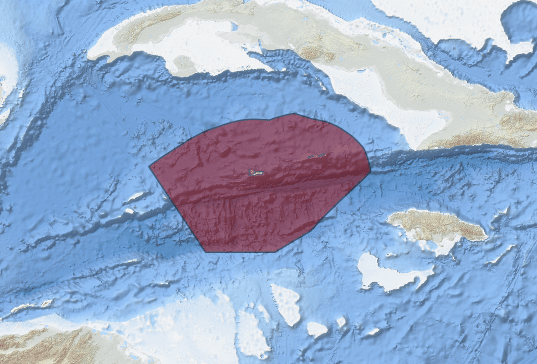
Forty-six years ago, in December 1977, Governor Thomas Russell issued Cayman Islands Government Proclamation No. 5 of 1977, establishing the Cayman Islands Fisheries Zone based on the principal of equidistance between Cayman and our neighbours Honduras, Jamaica and Cuba.
While this proclamation established Caymanian control of the fisheries resources in a large area around the Cayman Islands, it did not fully define our borders in accordance with the United Nations Convention of the Law of the Sea (UNCLOS).
Wilbur Welcome
Wilbur Welcome, acting chief officer in the Ministry of Lands, confirmed to the Compass that the Cayman Islands government, through the Governor’s Office and the Foreign and Commonwealth Development Office (FCDO), is seeking to resume negotiations with the Cuban and Jamaican governments to fully settle the boundaries of the waters between Cayman and our neighbours to the north and east.
When asked about the status of the maritime boundary negotiations, Welcome, in an emailed statement to the Compass, said, “We are in dialogue with the Government of Cuba through the HE Governor’s Office and FCDO regarding the setting of a date for the resumption of negotiations. During recent discussions with the Government of Jamaica they are also eager to resume negotiations in the near future.”
Once these negotiations are completed, it is expected that the Cayman Islands will have exclusive economic control of all the mineral resources of the seabed and the fisheries for an area of more than 40,000 square miles surrounding the territory.
Exclusive Economic Zone
The Cayman Islands Exclusive Economic Zone (EEZ) area between the Cayman Islands and Honduras was settled by treaty on 4 Dec. 2001, effectively giving control of not just the fisheries, but also all the seabed resources in a large area to the west and south of Grand Cayman.
Fortuitously for the Cayman Islands, the defined borders of the Cayman Islands EEZ included the short spreading centre area (where two tectonic plates move apart) located to the southwest of Grand Cayman. It is in this part of the Cayman Trench that significant deposits of important mineral resources are believed to exist, and while there are environmental considerations related to their possible extraction, and the minerals are too deep below the surface and too challenging for present generations to recover, the area holds important economic potential for future generations of Caymanians.
These mineral deposits were laid down over millions of years, through the action of deep-sea hydrothermal vents, where super-heated water from the Earth’s crust comes up through the seabed, and enriches the area, creating what are known as ‘polymetallic sulphide deposits’. These deposits are known to be rich in copper, lead, zinc, silver, gold and other important metallic elements, which are used in mobile phone technology and other applications.
There have been some efforts in the past to define the Cayman Islands border areas with Cuba and Jamaica, but it is not clear if there has been any progress over the last few years.
Jamaican claim
Jamaica has been claiming the Southwest Rock as part of their baseline archipelago status, but the rock is very small. It is often awash, has no trees growing on it, has no fresh-water resources, and there is no way it meets the definition of a place capable of “sustaining human habitation”, as required under UNCLOS Article 121 (3).
The section states, “Rocks which cannot sustain human habitation or economic life of their own shall have no exclusive economic zone or continental shelf.”
Despite this, the government of Jamaica has submitted this claim in compliance with the terms set out in the UNCLOS and forwarded this onto the UN secretary general.
It is hoped that our long-established connections and good relations with Jamaica and Cuba will allow the Cayman Islands to settle the boundaries.
Many Jamaicans are currently employed in the Cayman Islands, and this is reflected by statistics from the Bank of Jamaica that show total remittances sent from the Cayman Islands to Jamaica are higher than all the other countries in the Caribbean and Central America combined.
The Cayman Islands government has stated that their position regarding treaty negotiations is also based on the principals of equidistance, mutual respect and sovereign equality, which were the principals agreed upon by Jamaica and Cuba.
The maritime boundary between Cuba and the much-larger United States was established through an agreement that was reached in 1977. The final boundary effectively divided the maritime area between two variants of the equidistance methodology. This maritime boundary has been in force provisionally since 1978.
Source link : http://www.bing.com/news/apiclick.aspx?ref=FexRss&aid=&tid=670e04f2578549ddacecfcdaaa7690d8&url=https%3A%2F%2Fwww.caymancompass.com%2F2024%2F10%2F15%2Fcaymans-maritime-boundaries-still-need-defining%2F&c=15168318363466064343&mkt=en-us
Author :
Publish date : 2024-10-14 18:01:00
Copyright for syndicated content belongs to the linked Source.