For the latest information on storm activity in the Cayman Islands, as well as information on how to prepare for hurricane season, visit Storm Centre.
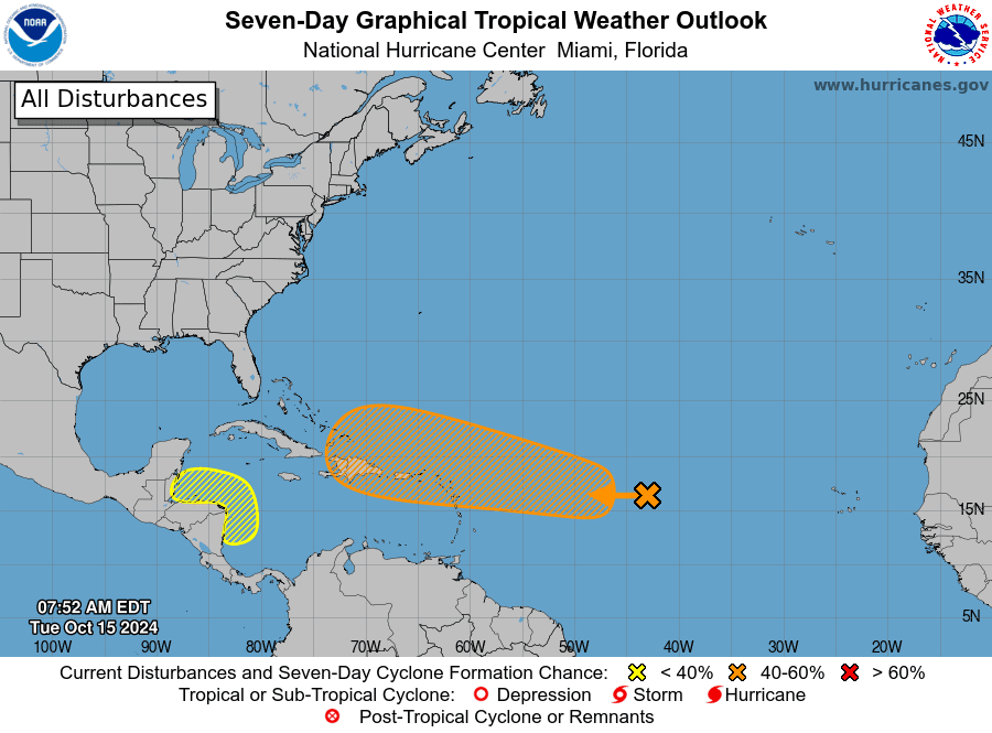
Two systems currently churning in the Atlantic basin have been marked for development in the coming days with forecasters saying one area, located in the central tropical Atlantic, could possibly intensify into a hurricane.
Forecasters at the Colorado State University Tropical Meteorology Project, in their latest two-week forecast released Tuesday morning, have given a 50% chance of above-normal accumulated cyclone energy activity – used to gauge the intensity of a hurricane and the hurricane season – during the next two weeks.
Rain expected
The systems do not pose a direct threat to the Cayman Islands at this time.
Shamal Clarke, of the Cayman Islands National Weather Service, said both areas are being monitored and the community can expect some rainy days ahead.
“The system over the southwest Caribbean has a low chance (20%) of development over the next 7 days. The area is expected to stay mainly near central America. Showers around the periphery of this area of showers will produce some isolated showers across the Cayman Islands between Wednesday and Friday of this week,” Clarke said in his emailed comment.
Seas might be choppy especially in and around these heavier showers, he added.
When it comes to the system in the Atlantic, Clarke said the National Weather Service is “definitely monitoring this area, especially given its projected movement”.
The system is projected to move near Hispaniola in seven days.
“There is a huge uncertainty as it relates to how it will develop and ultimately move. As a result it is too early to say if this area will have any impact on the Cayman Islands,” he said.
The area of low pressure located over the central tropical Atlantic, currently identified as Invest 94L, has a 60% chance of tropical-cyclone development in the next seven days according to the US National Hurricane Center.
The area, according to the forecast, could generate medium levels of accumulated cyclone energy given it looks to track through a reasonably tropical cyclone-favourable environment.
“Some global models as well as their individual ensemble members also develop this system and maintain the storm for several days, potentially getting ACE near the above-normal threshold,” Colorado State forecasters said in their Tuesday forecast.
Looking ahead
The National Hurricane Center is also monitoring an area in the western Caribbean with a 30% chance of tropical-cyclone development in the next seven days.
Colorado forecasters say if this system does form, it would likely only generate small levels of accumulated cyclone energy given that it looks to track over land relatively quickly.
“Global models do not show much additional signal for development in the next 10 days, although there are some signs of potential western Caribbean development later [next week],” the forecast stated.
The low probability area in the western Caribbean (30% chance) would likely track over land fairly quickly if it does form, consequently generating only minimal ACE, it added.
The NHC, in its Tuesday morning advisory, said the area of low pressure located over the central tropical Atlantic is producing disorganised showers and thunderstorms.
“This system is forecast to move generally westward, and environmental conditions could become more conducive for gradual development by the middle to latter part of this week. A tropical depression could form as the system begins moving west-northwestward and approaches or moves near the Leeward Islands late this week,” the NHC said.
The system has a low-formation chance through 48 hours at 30% and a medium-formation chance through seven days at 60%.
The NHC said a broad area of low pressure could develop over the southwestern
Caribbean Sea by the middle to latter portions of this week.
“Some gradual development is possible thereafter if the system stays over water while it moves slowly west-northwestward towards northern Central America. Regardless of development, locally heavy rainfall is possible across portions of Central America later this week,” the advisory said.
This system has a low chance of formation through seven days at 30%.
Source link : http://www.bing.com/news/apiclick.aspx?ref=FexRss&aid=&tid=670ffd87690540e884527d80bfcaefcd&url=https%3A%2F%2Fwww.caymancompass.com%2F2024%2F10%2F15%2Fforecasters-keeping-watch-as-two-systems-brew%2F&c=15011013467184021321&mkt=en-us
Author :
Publish date : 2024-10-15 11:16:00
Copyright for syndicated content belongs to the linked Source.


