
It’s November, the final month of the Atlantic hurricane season, and the active hurricane season of 2024 appears primed to deliver this month’s third named storm. This upcoming system could become a dangerous hurricane that will threaten Central America, Jamaica, and the Cayman Islands this weekend. Next week, it may move into the southeast Gulf of Mexico, with the Florida Gulf Coast, Florida Keys, and western Cuba potentially in its sights. The next name on the Atlantic list of storms is Sara.
This new named storm is expected to develop from a tropical wave currently approaching eastern Cuba which will interact with a sprawling low-pressure system known as a Central American Gyre, or CAG, now developing over Central America and the southwestern Caribbean. Rainfall in excess of 10-20 inches (250-500 mm) over Panama and Costa Rica over the next week could cause dangerous flash flooding and mudslides. Similar amounts could fall in eastern Honduras and northern Nicaragua if the embryonic system moves slowly near those areas late in the week, as some models suggest it will.
Figure 1. Odds of at least a tropical depression (winds of 25+ mph or 40 km/h) moving within 150-200 miles (160-322 km) of a given location for for the two-day period ending at 7 p.m. EST Friday, Nov. 15, according to the 0Z Tuesday, Nov. 12, run of the European model ensemble. A 95% chance of a tropical depression or tropical storm was indicated over the Western Caribbean (dark red colors). (Image credit:Â Weathermodels.com)
Conditions are quite favorable for development over the region, especially for so late in hurricane season, with light to moderate wind shear, a moist atmosphere, and sea surface temperatures near 29-30 degrees Celsius (84-86°F), which is about 1 degree Celsius above average. A strong ridge of high pressure to the north of the Caribbean will allow the developing system to drift slowly northward, potentially bringing heavy rains across Jamaica, the Cayman Islands, Cuba, and Haiti through this weekend.
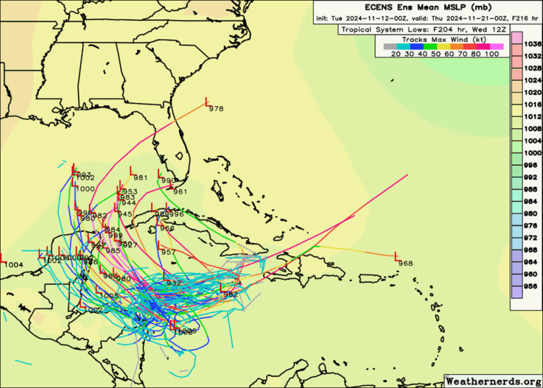 Figure 2. Track forecasts for the nine-day period ending Wednesday, Nov. 20, from the 0Z Tuesday, Nov. 12, run of the European ensemble model. Individual forecasts of the ensemble members are the lines color-coded by the wind speed in knots they predict; red or pink colors correspond to a hurricane. (Image credit:Â weathernerds.org)
The ridge steering this system will peak in intensity early next week, and it appears that the most likely path for any emerging system would be to arc clockwise around it, angling northwest and into the Gulf of Mexico by midweek before a possible northeastward turn toward southwestern Florida (as projected by the 12Z Tuesday run of the GFS model) or western Cuba (as suggested by the 0Z Tuesday run of the European model). West of this developing ridge, where the system may end up tracking, the predicted wind shear pattern for early next week (Fig. 3) is for a zone of unusually low wind shear over the Western Caribbean and southern Gulf of Mexico, more typical of the peak of hurricane season in September or October.
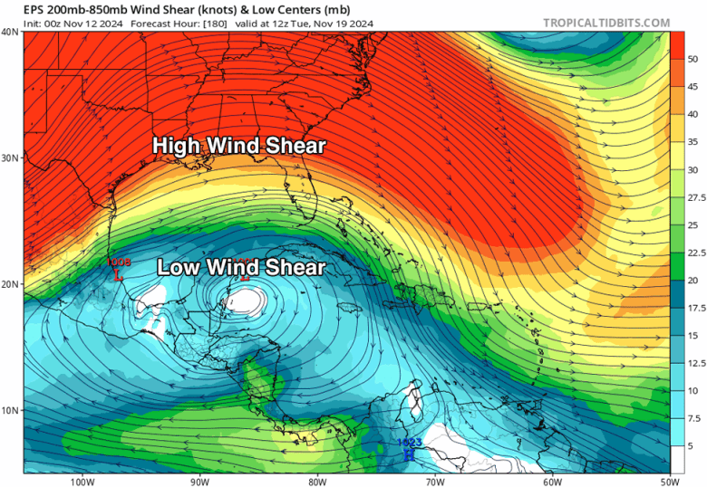 Figure 3. Wind shear forecast for next Tuesday, Nov. 19, from the 0Z Tuesday, Nov. 12, run of the European ensemble model. A zone of unusually low wind shear less than 20 knots (blue colors) – resembling a pattern one might expect in September rather than November – is predicted to be over the Western Caribbean and southern Gulf of Mexico, favoring development of a tropical cyclone. (Image credit: tropicaltidbits.com)
While ensemble forecast models are in strong agreement on development, it remains an open question which of three courses that development might take:
Far enough east to get picked up by a cold front pushing across the Bahamas, resulting in the system getting shunted across Hispaniola and then safely out to sea (a scenario less favored in the latest ensemble forecasts, see Fig. 2);
Far enough west to force land interaction with Central America, which could lead to disastrous rainfall there but would reduce the hurricane threat;
Just off the coast of Honduras and Nicaragua, which would still lead to potentially catastrophic rainfall there but also allow for the northwestward arc discussed above. Such a scenario would also maximize the potential for hurricane development, as it would allow the embryonic cyclone to remain over water.
As of Monday, sea surface temperatures were at record warmth when averaged across the Gulf of Mexico and at near-record warmth across the Caribbean, exceeded only by 2023. Readings of 28 to 30 degrees Celsius (84 to 86 degrees Fahrenheit) prevail from the Northwest Caribbean into the Florida Straits, and there remains ample deep-ocean heat content in this area. The unusually warm waters both at the surface and below would help support rapid intensification for any tropical storm or hurricane that might be nurtured by favorable atmospheric conditions, which appear likely to set up.
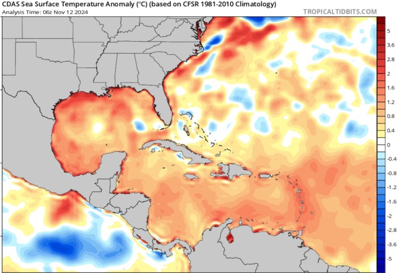 Figure 4. Departures from average sea surface temperature (anomalies) across the Caribbean and Gulf of Mexico, in degrees Celsius, as of November 12, 2024. Most areas are running 0.5 to 1.0 degrees C (1-2 degrees Fahrenheit) warmer than average for the date. (Image credit: tropicaltidbits.com)
Per analysis from @BMcNoldy, the Caribbean Sea’s deep, warm water (“ocean heat content”) appears tied with 2023 at record levels for this time of year.
That’s still much higher than pre-2023 average for the peak of #hurricane season. pic.twitter.com/d2b6qK1zG7
— Jonathan Erdman (@wxjerdman) November 12, 2024
The latest runs of both the GFS and European model predicted that the system would develop into a dangerous major hurricane over the Western Caribbean by early next week. Strong November hurricanes aren’t common in the Caribbean, and they are even rarer in the Gulf of Mexico, but they do happen. Just last week, Rafael reached Category 3 strength in the Northwest Caribbean just before reaching Cuba, and again in the southern Gulf of Mexico, just north of the Yucatan Peninsula. Rafael tied Hurricane Kate (1985) as the Gulf’s most powerful November hurricane on record (top sustained winds of 120 mph or 195 km/h). In mid-November 1985, Kate ground through northern Cuba and passed just south of Key West, Florida, then took an arcing path through the eastern Gulf, making landfall at Cat 2 strength (top sustained winds of 100 mph or 160 km/h) near Mexico Beach. Kate’s landfall on November 21 – just eight days before Thanksgiving Day – was the nation’s latest on record for any calendar year.
Adding to the potential threat: It’s King Tide season in South Florida, and with the full moon arriving on Friday, Nov. 15, some of the highest tides of the year will be observed Friday through next Tuesday. Any landfalling hurricanes that hits during that period will deliver increased storm surge damage because of the higher water levels.
For about a week, centered on the Full Moon on the 15th, we are expecting tidal flooding around every high tide in the #Miami area. This is the final King Tide episode of the season. 🌊@natetaminger.bsky.social @miamirosenstiel.bsky.social @miamiresilience.bsky.social
— Brian McNoldy (@bmcnoldy.bsky.social) 2024-11-12T10:58:22.021Z
Note that the predicted wind shear pattern for early next week (Fig. 3 above) shows high wind shear over northern Florida, but low wind shear over southern Florida, so the risks of a hurricane landfall are higher to the south than to the north.
Given the pattern in place, I think the only thing that might prevent a significant hurricane from forming by next week is if the system ends up further SW and moves over Honduras/Belize instead of staying offshore (EC-AIFS and some ensemble members go this route). If it does… pic.twitter.com/BLjx064AHA
— Andy Hazelton (@AndyHazelton) November 12, 2024
In its 7 a.m. EST Tuesday Tropical Weather Outlook, the National Hurricane Center (NHC) gave two-day and seven-day odds of tropical cyclone development in the Western Caribbean of 40% and 80%, respectively. As of Monday, no Hurricane Hunter missions for this system had been scheduled.
Only 28% of U.S. residents regularly hear about climate change in the media, but 77% want to know more. Help us bring climate news to more people.
Republish This Story
![]()
Republish our articles for free, online or in print, under a Creative Commons license.
Source link : http://www.bing.com/news/apiclick.aspx?ref=FexRss&aid=&tid=673398149ae1486cbd731f3ac251ef57&url=https%3A%2F%2Fyaleclimateconnections.org%2F2024%2F11%2Fyet-another-november-hurricane-threat-is-taking-shape%2F&c=17072192531480907022&mkt=en-us
Author :
Publish date : 2024-11-12 04:07:00
Copyright for syndicated content belongs to the linked Source.


