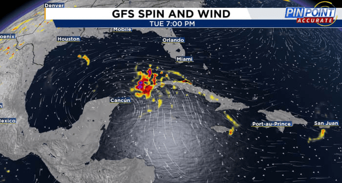
We have a new possible threat for tropical activity close to home in the western Caribbean.
What’s instigating this potential for development? Something called the “Central American Gyre.”
We’ve heard this term likely tossed around quite a bit but if you aren’t new to tropical storm and hurricane forecasting, what exactly is the gyre?
In its simplest form, the gyre over Central America, as the name implies, is strictly broad low pressure that results from focused rising motion over that particular region.
Central American Gyre
As the air begins to rise more and more over a period of time, it then starts to turn cyclonically or counter-clockwise. Rising air is a key ingredient to storm development. Where you have rising air you have what’s called instability.
With instability, you get clouds and eventually lots of thunderstorms.
The gyre slowly turning the air like a spoon stirring a pot of water can attract some extra energy into its vortex. These small pieces of localized spin are what then can turn into future tropical cyclones, aided by the extra lift that they’re given courtesy of our gyre. To forecast tropical development brought on by the Central American gyre (CAG for short) can be notably tricky.
Models tend to struggle with where the gyre could pull in extra bits and pieces of tropical energy, and struggle even more so when trying to model what these areas of energy look like as they’re ejected back into the general environment.
As we await the potential organization of our next named storm induced by the gyre likely to form over Central America, there will be lots of uncertainty ahead. Traditionally in a pattern like this we’re faced with two areas where “genesis” of our named storm should occur. One would be the West Caribbean, where we’ve seen notable gyre storms in the past. Major Hurricanes Idalia and Michael immediately come to mind.
The other would be the southwestern Gulf of Mexico, called the Bay of Campeche.
From there especially given the time of year as we make the transition to fall, we’ll likely see this pulled north to unfortunately impact someone in the U.S. as it gets its act together.
We’re simply waiting and watching as things maybe manifest further into next week.
For now, stick with News 6 to get you the accurate weather information you need to prepare well before a storm threatens our local area.
More Stories Like This In Our Email Newsletter
Copyright 2024 by WKMG ClickOrlando – All rights reserved.
Source link : http://www.bing.com/news/apiclick.aspx?ref=FexRss&aid=&tid=66ec157977e14b8d9c31ad7bf9ecfc85&url=https%3A%2F%2Fwww.clickorlando.com%2Fweather%2F2024%2F09%2F18%2Fcentral-american-gyre-could-spark-tropical-system-heres-what-it-is%2F&c=10924615794276740174&mkt=en-us
Author :
Publish date : 2024-09-18 15:47:00
Copyright for syndicated content belongs to the linked Source.


