ItтАЩs been a week since Milton raced out to sea after devastating parts of west-central Florida and setting off a deadly outbreak of tornadoes тАУ FloridaтАЩs biggest tornado outbreak on record.
Since MiltonтАЩs demise, weтАЩve seen no active tropical systems anywhere in the Atlantic, the longest stretch of inactivity in a month and before the historic run of late-season activity that included 6 named storms, of which 5 became hurricanes and 3 of those Category 3 or stronger, capped off by Category 5 Milton, the most intense hurricane in nearly two decades.
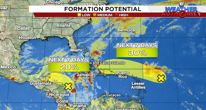
While we have two candidates that could break the streak this week in the Atlantic тАУ including Invest 94L moving through the central Atlantic тАУ the window for either to do so is quickly closing as development odds dwindle.
Invest 94L to move north of Puerto Rico and the U.S. Virgin Islands tomorrow
The disturbance weтАЩve been following this week through the central Atlantic тАУ designated Invest 94L тАУ continues to struggle. Dry, sinking air has plagued its organization and the lack of persistent thunderstorms is keeping its circulation broad and messy.
Models have largely backed down on development and NHC again today lowered development odds. The window for development will quickly close by late weekend as the disturbance gets shredded by a firehose of wind shear as it nears eastern Cuba.
Forecast tracks for Invest 94L from the Friday morning run of the European model ensemble system. Each track represents a forecast scenario based on different starting conditions. The upshot is that models expect little in the way of development before 94L (or what forms from it) dissipates across eastern Cuba into early next week. Credit: Weathernerds.org.
Nevertheless, the disturbance will enhance the threat for heavy rainfall across parts of the Greater Antilles тАУ including Puerto Rico, the U.S. Virgin Islands, Haiti, and the Dominican Republic тАУ through the weekend.
Western Caribbean disturbance moves inland this weekend
A broad area of low pressure over the western Caribbean is forecast to pivot inland across Central America on Saturday. As weтАЩve discussed in the newsletter this week, odds for development are low since the system is quite broad, but the upshot regardless will be heavy rainfall and the threat of widespread flooding from northern Honduras to Belize and Guatemala to parts of southern Mexico into the next week.
Total rainfall forecast through next Tuesday, October 22nd, from the European forecast model for Central America and southern Mexico showing widespread totals of 6-12 inches (150-300 mm), with locally higher totals approaching 20 inches (500 mm), from the disturbance moving in from the western Caribbean. Credit: Weathermodels.com.MJO puts the Atlantic to bed for the next week or two
As we discussed in MondayтАЩs newsletter, the large see-saw pattern of upper-level winds that we track around the globe known as the Madden-Julian Oscillation, or MJO, is now in the suppressed phase over the Atlantic. The yin and yang configuration of the MJO often means a busy period тАУ as we saw for the first few weeks of October тАУ is quickly followed up by a quiet period which weтАЩve entered now.
According to our best MJO trackers (the MJO is difficult to тАЬseeтАЭ by the models so certain tracking algorithms are more useful than others), the suppressed phase should persist over the Atlantic for the next 10 days or so.
Areas of rising (blue/cool colors) and sinking (red/warm colors) air straddling the equator (between 15┬░N and 15┬░S) by global longitude (x-axis) from middle September (top of the chart) through November 17th (bottom of the chart). The time vs. longitude chart is known as a Hovm├╢ller diagram and shows the global progression of the MJO. Rising air that favored development (part of the Madden-Julian Oscillation or MJO) in the Atlantic from around the third week of September up until Milton has transitioned to sinking air as the suppressed phase moves in. This should largely inhibit widespread development until it moves out at the end of the month and gets replaced by another active pulse. Since the next active pulse isnтАЩt moving in until around the first week of November, it may be a little late in the season to expect much in the way of significant development. Credit: ECMWF.
As the calendar turns from October to November, another active pulse will push into the Caribbean and Atlantic. WeтАЩre probably a little late in the game to expect much in the way of significant activity, but that should be the last hurrah for the Atlantic before the season really shuts down.
About 90% of typical hurricane season activity is complete by the end of October. Hurricane season officially runs through November 30th.
Copyright 2024 by WPLG Local10.com – All rights reserved.
Source link : http://www.bing.com/news/apiclick.aspx?ref=FexRss&aid=&tid=671170b6550a493da423c4934119decf&url=https%3A%2F%2Fwww.local10.com%2Fweather%2Fhurricane%2F2024%2F10%2F17%2Fdevelopment-odds-dwindling-in-the-atlantic%2F&c=1311960645110183975&mkt=en-us
Author :
Publish date : 2024-10-17 07:14:00
Copyright for syndicated content belongs to the linked Source.


