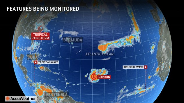
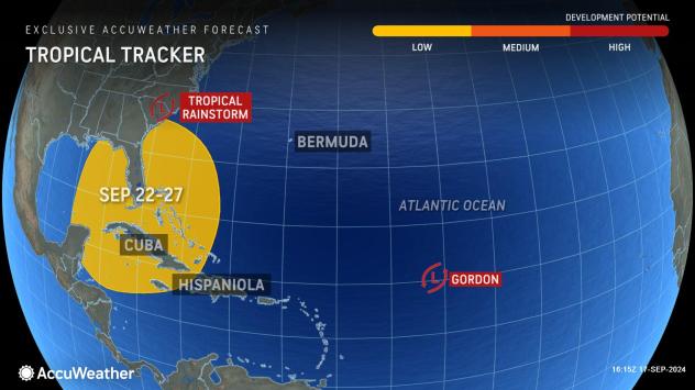
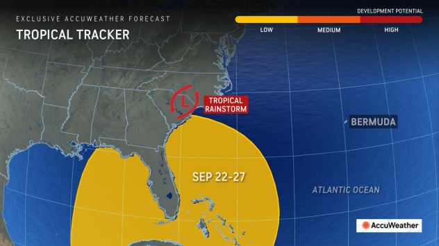
An area close to Central America, Cuba and Florida has the potential to give birth to the next significant tropical threat to the southeastern United States in the days ahead, AccuWeather meteorologists warn.
“The region we are closely watching is more commonly a threat to tropical development in the late spring or mid- to late autumn,” AccuWeather Lead Hurricane Expert Alex DaSilva stated, “There’s even evidence of the Central America gyre now, which is also more common in the spring and later in the autumn.”
The gyre is a vast but weak, slow-spinning storm, and it has set up over Central America. A gyre over the warm water of the Caribbean makes it easier for clusters of showers and thunderstorms to form, which can evolve into tropical depressions and storms either on the Atlantic or Pacific sides of Central America.
GET THE FREE ACCUWEATHER APP
Typically during the middle to late part of September, tropical storms and hurricanes are generated by tropical waves that originate from Africa. However, in recent weeks, unusual conditions have disrupted the evolution of tropical waves, resulting in fewer named storms.
Not only have the tropics been behaving strangely, but so have weather patterns in general across the U.S. Waves of cool air moved into the Southwest, and an unusually strong jet stream-level storm in the Southeastern states formed in the wake of Francine. The jet stream storm helped create a potent tropical rainstorm that made landfall in North Carolina-a setup more common for mid- to late October.

The weirdness may continue should a potent tropical storm or hurricane spin up next week more so from the Central America gyre rather than a tropical wave over the Atlantic Ocean.
“Given how warm waters typically are in the region and energy from the Central America gyre, there is the potential for any system that forms over the western Caribbean to the central Gulf to quickly intensify and track into the U.S.,” DaSilva said.

There will likely be some stiff breezes (wind shear) near the U.S., but systems that move with the shear rather than against it are sometimes less negatively affected by it, DaSilva explained.
AccuWeather has designated the formation window from Sunday, Sept. 22, through Friday, Sept. 27. This only represents the period when a tropical depression or storm may form and not the entire life cycle. Any landfall could occur days after the formation period.

Residents, visitors, fishing, shipping, and cruise interests from Central America to southeastern Mexico, Cuba, the U.S. Gulf Coast, the southern Atlantic coast, and the Bahamas should monitor the situation.
Want next-level safety, ad-free? Unlock advanced, hyperlocal severe weather alerts when you subscribe to Premium+ on the AccuWeather app. AccuWeather Alerts™ are prompted by our expert meteorologists who monitor and analyze dangerous weather risks 24/7 to keep you and your family safer.
Source link : http://www.bing.com/news/apiclick.aspx?ref=FexRss&aid=&tid=66e9b15df54d4cb89c98332da31a5589&url=https%3A%2F%2Fwww.aol.com%2Fweather%2Ftropical-threat-us-may-arise-154308439.html&c=3524706161713551551&mkt=en-us
Author :
Publish date : 2024-09-17 04:43:00
Copyright for syndicated content belongs to the linked Source.


