Hurricane Rafael threatens Cuba as major hurricane
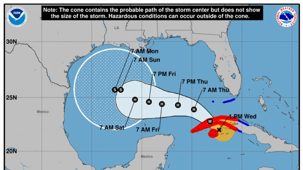
Hurricane Rafael is closing in on Cuba as a major hurricane. The storm is expected to continue across the Gulf of Mexico toward Louisiana.
For the latest information on Hurricane Rafael, you can find Thursday’s storm tracker file here.
Hurricane Rafael has strengthened into a Category 3 storm as it approaches the coast of western Cuba, according to the National Hurricane Center.
Rafael was located about 85 miles south of Havana, Cuba, on Wednesday afternoon, the NHC said. The storm is moving toward the northwest, and a “general northwestward motion” is anticipated over the next day or two, followed by a west-northwestward turn in the Gulf of Mexico.
“On the forecast track, Rafael is expected to make landfall in western Cuba this afternoon,” the NHC said in its 1 p.m. ET advisory Wednesday. “Rafael is forecast to move into the southeastern Gulf of Mexico tonight.”
Rafael currently has maximum sustained winds near 115 mph with higher gusts, hurricane forecasters said, and some additional strengthening is likely before the storm makes landfall in Cuba this afternoon. The hurricane is forecast to weaken over Cuba but is expected to emerge into the southeastern Gulf of Mexico as a hurricane.
Rafael swiped west of Jamaica on Tuesday afternoon, where authorities opened four emergency shelters but reported no deaths or injuries despite the heavy rain.
Heavy rainfall is expected to impact areas of the Western Caribbean through early Thursday, particularly across Jamaica and the Cayman Islands into western Cuba, according to the NHC. Rainfall totals between 4 to 8 inches are expected across western Cuba, with isolated higher totals up to 12 inches in areas of higher terrain.
The hurricane center said storm surge could raise water levels as much as 9 to 14 feet above normal tide levels in areas of onshore winds along the southern coast of Cuba, including the Isle of Youth.
“The combination of a storm surge and the tide will cause normally dry areas near the coast to be flooded by rising waters moving inland from the shoreline,” the NHC said Wednesday afternoon.
Hurricanes, tornadoes, snow and heat: Sign up for USA TODAY’s Climate Point newsletter for exclusive weather analysis.
Florida Keys could see impacts starting Wednesday
The hurricane center said hurricane conditions are expected in western Cuba and the Isle of Youth through Wednesday evening, and tropical storm conditions are expected in parts of west-central Cuba and the lower and middle Florida Keys Wednesday afternoon and evening.
Rainfall totals of 1 to 3 inches are also expected for the lower and middle Florida Keys, with a few tornadoes also possible for the area and for the far southwestern Florida mainland.
What about the Gulf Coast?
With uncertainty lingering in the long-range forecast, the NHC said it’s too early to determine what, if any, impacts Rafael could bring to portions of the northern Gulf Coast. By the end of the week, swells are expected to spread across much of the Gulf.
Forecasts show the storm could make landfall anywhere from the Texas coast to the Florida Panhandle around the weekend, according to AccuWeather, which said the highest probability of landfall is along the central Louisiana coast as a tropical storm. Other possible scenarios include the storm turning west and moving over the western coast of Mexico.
The good news: Drier air and stronger vertical wind shear in the Gulf are expected to weaken the hurricane by the time it draws close to the U.S. mainland. “This will not be a situation where there is a strengthening major hurricane that makes landfall in the U.S., but rather something less intense in terms of wind intensity,” AccuWeather’s forecast says.
Hurricane Rafael path tracker
This forecast track shows the most likely path of the center of the storm. It does not illustrate the full width of the storm or its impacts, and the center of the storm is likely to travel outside the cone up to 33% of the time.
Hurricane Rafael spaghetti models
Illustrations include an array of forecast tools and models, and not all are created equal. The hurricane center uses only the top four or five highest performing models to help make its forecasts.
Gabe Hauari is a national trending news reporter at USA TODAY. You can follow him on X @GabeHauari or email him at Gdhauari@gannett.com.
Source link : http://www.bing.com/news/apiclick.aspx?ref=FexRss&aid=&tid=672cc718c89b4b09b571b7bb5115e54f&url=https%3A%2F%2Fwww.usatoday.com%2Fstory%2Fnews%2Fweather%2F2024%2F11%2F06%2Fhurricane-rafael-tracker-path-spaghetti-models%2F76087510007%2F&c=9835291048085911830&mkt=en-us
Author :
Publish date : 2024-11-07 00:03:00
Copyright for syndicated content belongs to the linked Source.
