Along and ahead of the zone of showers and thunderstorms, wind shear is low, and the water is sufficiently warm to foster tropical development.
Wind shear is associated with breezes in the atmosphere that blow from one direction or change direction abruptly. When these breezes are strong, wind shear is strong and can hinder tropical development.
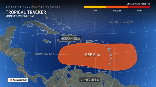
In order for a tropical depression to be declared by the National Hurricane Center, there must be complete circulation with maximum sustained winds of 38 mph or less. Usually, showers and thunderstorms cluster near a center of circulation on satellite images and radar when a tropical depression is about to form.
“On Friday morning, there were as many as five clusters of thunderstorms within the moist plume, but none showed any evidence of a circulation,” Rayno said.
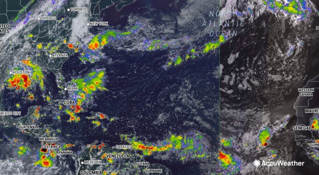
This wide-view image of the Atlantic basin was captured on Friday, Aug. 30, 2024. (AccuWeather RealVue™ Satellite)
Regardless of organization, rounds of drenching showers and gusty thunderstorms will move slowly westward across portions of the Leeward and Windward islands that make up the Lesser Antilles on the eastern edge of the Caribbean Sea.
The greatest concentration of the downpours will be over the Windwards.
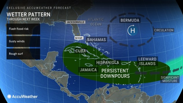
The downpours will bring needed rainfall to areas but may also trigger flash flooding in extreme cases. Several inches of rain may pour down in some locations from this weekend into early next week. Parts of the Windwards were still recovering from extensive damage from Hurricane Beryl earlier this summer and may still be experiencing damaged infrastructure.
GET THE FREE ACCUWEATHER APP
Early in July, rapidly strengthening Hurricane Beryl blasted Grenada and St. Vincent and the Grenadines in the Windwards with ferocious winds, torrential rain and storm surge. With 165-mph winds at peak intensity, Beryl became the strongest July hurricane on record and the earliest Category 5 hurricane on record. Beryl is associated with dozens of fatalities and billions of dollars in damage from the Caribbean to the United States.
“Once this broad feature gets into the Caribbean next week, the chances of development will likely increase substantially,” Rayno said, “We will likely have a named system–a tropical storm–in there.”
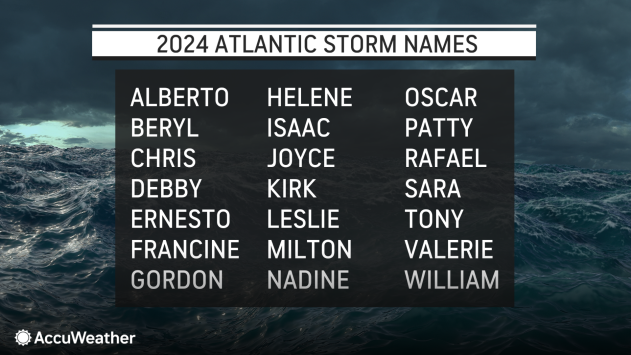
The next name on the list of tropical storms for the 2024 Atlantic hurricane season is Francine.
There is a wide-ranging area where a tropical storm or hurricane might track after departing the Caribbean during the weekend after Labor Day. Steering breezes might continue to guide the system westward into Central America and southeastern Mexico during the second week of September. In another scenario, which poses a potential direct threat to the U.S., steering breezes and interactions with the jet stream could pull a tropical storm or hurricane into the Gulf of Mexico.
It is possible that more than one feature may organize in the broad zone of showers and thunderstorms.
AccuWeather meteorologists are also monitoring a separate area in the Atlantic for tropical development.
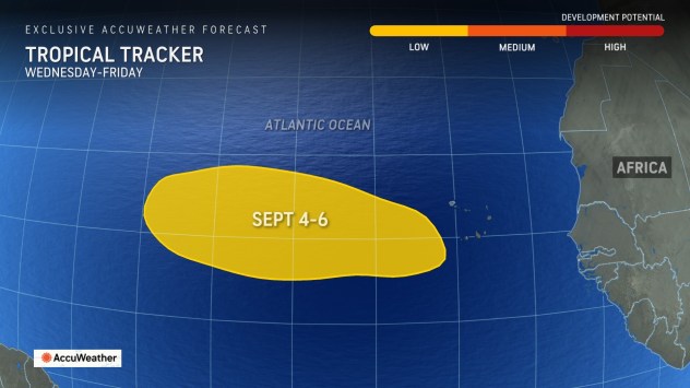
As a batch of thunderstorms moves well off the coast of Africa later next week, a tropical storm may form over the middle of the ocean. Anticipated steering winds would keep this feature away from land.
Meanwhile, on the doorstep of the U.S., there are two additional areas being monitored over the next few days to next week. One area is in the northwestern Gulf of Mexico over the holiday weekend. It has been dubbed by AccuWeather meteorologists as a tropical rainstorm to raise attention to its impacts of heavy rain, possible flooding and perhaps locally gusty winds in parts of Texas and Louisiana.
Another area that will be watched closely for development later next week is just off the Atlantic coast of the U.S.
After Francine, the following three storm names for 2024 are Gordon, Helene and Isaac.
AccuWeather maintains that 2024 will have a very active hurricane season with the current number of systems that have developed still on par with the historical average and the busiest part of the season just ahead. There is still a high chance that several storms may undergo rapid intensification as Beryl did.
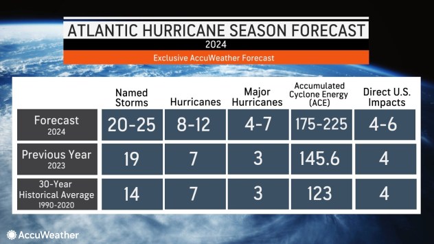
“In a new development, AccuWeather hurricane experts now assess that 20-23 named storms are more likely than 20-25. This adjustment is fewer named storms than many other sources are predicting,” explained AccuWeather Chief Meteorologist Jon Porter. “The reason for this assessment is the long lull that has occurred in recent weeks when there have been no named storms during what is typically an increasingly active part of the hurricane season.”
While it is rare for an active named system not to be present during the Labor Day weekend, conditions in the Atlantic can change quickly. Busy periods, when multiple named systems will be spinning in the basin, are still anticipated, including the potential for just that over the next week to 10 days.
Want next-level safety, ad-free? Unlock advanced, hyperlocal severe weather alerts when you subscribe to Premium+ on the AccuWeather app. AccuWeather Alerts™ are prompted by our expert meteorologists who monitor and analyze dangerous weather risks 24/7 to keep you and your family safer.
Source link : http://www.bing.com/news/apiclick.aspx?ref=FexRss&aid=&tid=66d23f11872c4ef688b04116964465a7&url=https%3A%2F%2Fwww.aol.com%2Fweather%2Fseptember-surge-tropical-activity-increasing-170031288.html&c=11617880642820415124&mkt=en-us
Author :
Publish date : 2024-08-29 23:01:00
Copyright for syndicated content belongs to the linked Source.


