ORLANDO, Fla. – Hit-or-miss showers are likely Sunday in Central Florida, similar to the previous day.
Some areas may experience soaking rain while others may remain dry. Regardless of where you are, plan accordingly for potential weather changes.
Sunday’s rain chances
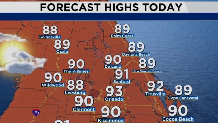
Residents can expect a warm day as temperatures climb into the lower 90s, potentially feeling as high as 102 degrees due to high humidity levels.
[EXCLUSIVE: Become a News 6 Insider (it’s FREE) | PINIT! Share your photos]
Isolated downpours are expected throughout the afternoon, particularly along the Interstate 4 corridor. Areas such as Sumter and Lake counties may see showers around 2-3 p.m., with more scattered showers and storms expected in Brevard, Osceola and Flagler counties by early evening.
As the evening progresses, most showers are expected to taper off, although coastal areas may still experience some rain due to strong coastal winds.
Pinpointing the tropics:
The National Hurricane Center is monitoring a tropical wave over Central America and South America with a 50% chance of tropical development in the western Caribbean Sea and parts of the Gulf of Mexico. Long-range models suggest that a low-pressure system could develop in the area mid- to late-week, potentially becoming a tropical depression.
8 A.M. UPDATE
Two other areas to monitor long-term. One has a high chance for tropical development and the other has a lower chance.
More Stories Like This In Our Email Newsletter
Get today’s headlines in minutes with Your Florida Daily:
Copyright 2024 by WKMG ClickOrlando – All rights reserved.
Source link : http://www.bing.com/news/apiclick.aspx?ref=FexRss&aid=&tid=66f9af2741044f90b4881cfcc3a50b04&url=https%3A%2F%2Fwww.clickorlando.com%2Fweather%2F2024%2F09%2F29%2Fwarm-breezy-day-with-hit-or-miss-showers-in-central-florida%2F&c=2197202495638644445&mkt=en-us
Author :
Publish date : 2024-09-29 05:28:00
Copyright for syndicated content belongs to the linked Source.