THURSDAY MORNING UPDATE:
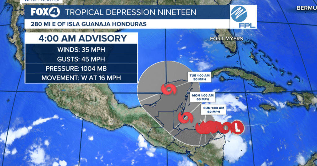
Patience is key as we watch Potential Tropical Cyclone#19 meander in the Caribbean through the weekend. Whether or not it impacts the Gulf, or where, is yet to be known, as many factors are at play in a forecast beyond one week.
HERE’S WHAT WE KNOW:
Potential Tropical Cyclone #19 is forecast to become a depression or Tropical Storm Sara later this afternoon, producing up to 20″ of rainfall and dangerous flooding to parts of central America, where the system is forecast to remain nearly stationary over the weekend.
Maximum sustained winds are near 35 mph with higher gusts. Strengthening is expected during the next few days, and the system is forecast to become a tropical storm today and continue strengthening as it moves near the coast of Central America.
COULD IT HIT SWFL?
It is too early to tell if, when or where the system could emerge into the Gulf of Mexico. How it interacts with an approaching front and trough of low pressure early to mid next week will dictate its path. For now, this is something to monitor but not worry about just yet.
THREATS TO CENTRAL AMERICA:
RAINFALL: Through early next week, rainfall amounts of 10 to 20 inches with isolated storm totals around 30 inches area expected over northern Honduras. This rainfall will lead to widespread areas of life-threatening and potentially catastrophic flash flooding and mudslides, especially along and near the Sierra La Esperanza.
Elsewhere across the rest of Honduras, Belize, El Salvador, eastern Guatemala, and western Nicaragua, Potential Tropical Cyclone Nineteen is expected to produce 5 to 10 inches of rain with localized totals around 15 inches through early next week. This will result in areas of flash flooding, perhaps significant, along with the potential of mudslides.
WIND: Hurricane conditions are possible within the watch area by Friday, with tropical storm conditions possible by late Thursday. Tropical storm conditions are possible within the watch area by late Thursday.
STORM SURGE: Storm surge could raise water levels by as much as 1 to 3 feet above normal tide levels along the immediate coast near in areas of onshore winds along the northern coast of Honduras. Near the coast,the surge will be accompanied by large and destructive waves.
WATCHES AND WARNINGS:
The government of Honduras has issued a Hurricane Watch from Punta Castilla eastward to the Honduras/Nicaragua Border.
The government of Nicaragua has issued a Tropical Storm Watch from the Honduras/Nicaragua Border southward to Puerto Cabezas.
Source link : http://www.bing.com/news/apiclick.aspx?ref=FexRss&aid=&tid=6735e89d73ba4a7baaea0ae2f4506748&url=https%3A%2F%2Fwww.fox4now.com%2Fweather%2Fhurricane-center%2Ftropics-potential-tropical-cyclone-19-officially-forms-now-what&c=148494560392176161&mkt=en-us
Author :
Publish date : 2024-11-13 17:56:00
Copyright for syndicated content belongs to the linked Source.
