CNN
—
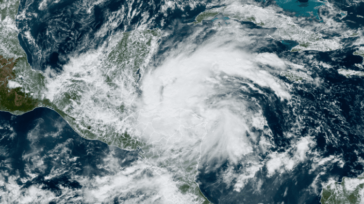
Tropical Storm Sara is here and closing in on Central America where it will unleash disastrous flooding rain in the region. It’s the first and potentially most serious threat posed by a storm that should enter the Gulf of Mexico next week.
Sara, which formed Thursday afternoon as it closed in on the Honduras-Nicaragua border, is the 18th named storm of the 2024 Atlantic hurricane season. It’s a season that’s lived up to initial hyperactive forecasts and hasn’t played by the rules.
Tropical activity should be winding down in November, but Sara is now the third named storm this month thanks to exceptionally warm water wrought by climate change.
The forecast beyond early next week is still highly uncertain, but the forecast is trending toward the US avoiding the worst Sara has to offer. The National Hurricane Center is still urging those in the eastern Gulf of Mexico, including Florida, the Florida Keys and Cuba, to closely monitor forecasts for changes.
Sara has 40 mph maximum sustained winds and will strengthen slightly as it moves toward Honduras Thursday. It will slow down considerably and skim along the coast Friday and through the weekend.
The storm may get so close to Honduras that it makes a few brief landfalls this weekend but will still be able to tap into the warm water of the western Caribbean Sea to sustain itself.
Tropical storm alerts have been issued for parts of Honduras and Nicaragua. The storm’s rain began Thursday in both countries and strong winds will arrive as soon as the evening and ramp up Friday.
The storm will bring “life-threatening” flooding rainfall up to 30 inches to Honduras and double-digit rainfall totals to other parts of Central America, the NHC warned. That could mean “widespread areas of life-threatening and potentially catastrophic flash flooding and mudslides.”
It will then threaten Belize and the Yucatán Peninsula with storm surge and gusty winds by early next week, so residents should prepare.
There are a few potential scenarios on the table for how formidable the storm could be and whether it could reach the US next week. They all hinge on how close Sara gets to the coast of Honduras over the next few days and what happens once it reaches the Yucatán Peninsula.
The latest forecast calls for Sara to spend much more time interacting with land than originally thought, limiting its overall strength. The official forecast from the hurricane center has the system hugging the coast of Honduras and moving just inland over the weekend, but this could change.
If it makes landfall in Honduras this weekend and moves far enough inland, it could deteriorate while over land, cut off from the warm water fueling it. This scenario would bring strong winds and torrential rain to Central America, but could keep the storm away from the US entirely or have it approach as a very weak storm.
If Sara remains very close to the coast of Central America, but briefly moves over land, it could eventually emerge in the southern Gulf of Mexico next week as a weak, but slightly stronger storm than in the first scenario. This scenario would lessen the blow if it were to reach the US. It would still unleash life-threatening flooding rainfall in Central America and head for dangerous strike on Belize and Mexico’s Yucatán Peninsula.
A now less likely third scenario keeps the storm far enough away from the coast and over the Caribbean’s tremendously warm water to strengthen considerably — and possibly rapidly intensify. This would bring more substantial impacts to Central America, the Yucatán and Belize and a much more troubling forecast for the US.
A stronger storm would be a major problem as sea surface temperatures in the Caribbean are currently their second-warmest on record and are warmer than they should be at the peak of hurricane season. Warmer bodies of water are fueling stronger storms and more rapid intensification as the world warms due to fossil fuel pollution.
The Yucatán Peninsula will also be a major factor in what kind of shape Sara is in once it reaches or if it reaches the Gulf of Mexico. It may struggle to stay intact if it enters and spends more time over the Yucatán next week as a weaker tropical storm or tropical depression.
Sara could be ragged by the time it reaches the Gulf of Mexico and potentially makes a turn toward the eastern Gulf Coast, but the Gulf is record-warm for this time of year and likewise could boost the system’s strength.
Source link : http://www.bing.com/news/apiclick.aspx?ref=FexRss&aid=&tid=67363a3bf7764f27aa414861f7b17a49&url=https%3A%2F%2Fwww.cnn.com%2F2024%2F11%2F14%2Fweather%2Ftropical-storm-sara-florida-hurricane-season-climate%2Findex.html&c=8738557974340012543&mkt=en-us
Author :
Publish date : 2024-11-14 04:50:00
Copyright for syndicated content belongs to the linked Source.
