‘Hope in humanity’: How North Carolina is recovering after Helene
A month after Hurricane Helene brought unprecedented flooding to western North Carolina, people share how they’re coping, grieving and re-building.
USA TODAY
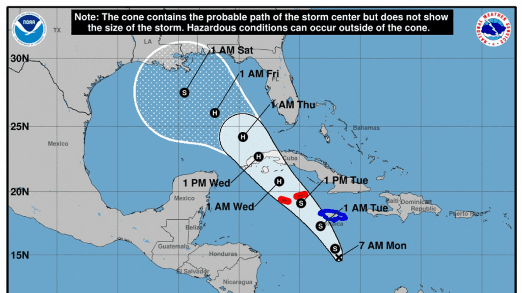
Tropical Storm Rafael formed in the Caribbean on Monday, a storm that’s predicted to intensify into a hurricane and threaten the U.S. Gulf Coast by this weekend, the National Hurricane Center said.
However, given significant uncertainties in the long-range forecast track and intensity, it is too soon to determine what, if any, impacts could occur in the U.S., the hurricane center said.
“There has never been a tropical storm or hurricane landfall in Texas, Louisiana or Mississippi during November and December. So that would be quite a milestone, but this does not mean that people along the central and western Gulf Coast should let their guard down,” AccuWeather lead hurricane expert Alex DaSilva said.
Rafael is the 17th named storm of the 2024 Atlantic hurricane season, according to Colorado State University hurricane researcher Phil Klotzbach. An average year sees 14 storms.
Jamaica, Cuba to see first impacts
As of Monday afternoon, Rafael was located about 175 miles south of Kingston, Jamaica, and had maximum sustained winds of about 45 mph, with higher gusts.
“A northwestward motion is expected later today and forecast to continue for the next few days,” the hurricane center said in an advisory Monday. The system is expected to move near Jamaica Monday evening, be near or over the Cayman Islands on Tuesday and approach Cuba on Wednesday, according to the NHC.
Forecasters said Monday that “the system could be near or at hurricane intensity when it passes near the Cayman Islands and Cuba.”
The NHC said tropical storm conditions are expected in Jamaica by Monday evening and hurricane conditions are possible in the Cayman Islands by Tuesday afternoon. Heavy rainfall is expected to impact areas of the Western Caribbean. The heaviest rainfall is likely to occur over Jamaica and portions of Cuba through midweek.
Rainfall totals from 3 to 6 inches – up to 9 inches in some places – are expected, and flooding and mudslides could occur over portions of Jamaica and Cuba, the NHC said.
In three or four days, when the system reaches the central Gulf, a sharp increase in southwesterly vertical wind shear, drier air and slightly cooler waters should end the strengthening trend and induce weakening, forecasters said.
Patty no longer a tropical cyclone
The hurricane center said Monday that Patty is no longer a tropical storm or cyclone in the far eastern Atlantic Ocean.
“The remnants of Patty will turn toward the east-northeast later today,” the hurricane center said. “Between tonight and Tuesday, heavy rainfall across portions of Portugal and western Spain is possible from the remnants of Patty.”
Atlantic storm tracker
Gabe Hauari is a national trending news reporter at USA TODAY. You can follow him on X @GabeHauari or email him at Gdhauari@gannett.com.
Source link : http://www.bing.com/news/apiclick.aspx?ref=FexRss&aid=&tid=672a30cfc2214106b642b7f35763e86e&url=https%3A%2F%2Fwww.usatoday.com%2Fstory%2Fnews%2Fweather%2F2024%2F11%2F04%2Fstorm-tracker-nhc-caribbean-tropical-depression%2F76041399007%2F&c=241549939036057572&mkt=en-us
Author :
Publish date : 2024-11-05 00:06:00
Copyright for syndicated content belongs to the linked Source.
