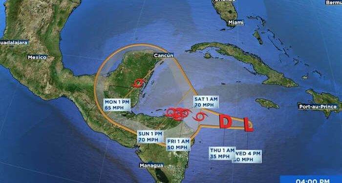
At 700 PM EST (0000 UTC), the disturbance was centered near latitude 16.1 North, longitude 79.5 West. The system is moving toward the west near 6 mph (9 km/h). A slow westward motion should continue for another day or two, taking the system across the western Caribbean Sea. The disturbance is expected to stall and meander near the north coast of Honduras late Friday and through the weekend.
Maximum sustained winds are near 30 mph (45 km/h) with higher gusts. The system is forecast to become a tropical storm on Thursday and continue strengthening, if it remains over water. * Formation chance through 48 hours, high, 90 percent. * Formation chance through 7 days, high, 90 percent.
The estimated minimum central pressure is 1005 mb (29.68 inches).
Tropics Satellite at 6:34 Wednesday Evening, November 13thWatches and Warnings
CHANGES WITH THIS ADVISORY:
None
SUMMARY OF WATCHES AND WARNINGS IN EFFECT:
A Hurricane Watch is in effect for, * Punta Castilla to the Honduras/Nicaragua Border
A Tropical Storm Watch is in effect for, * Honduras/Nicaragua Border to Puerto Cabezas
A Hurricane Watch means that hurricane conditions are possible within the watch area. A watch is typically issued 48 hours before the anticipated first occurrence of tropical-storm-force winds, conditions that make outside preparations difficult or dangerous.
A Tropical Storm Watch means that tropical storm conditions are possible within the watch area, generally within 48 hours.
For storm information specific to your area, please monitor products issued by your national meteorological service.
Tropics Models at 6:35 Wednesday Evening, November 13thLand Hazards
Key Messages for Potential Tropical Cyclone Nineteen can be found in the Tropical Cyclone Discussion under AWIPS header MIATCDAT4 and WMO header WTNT44 KNHC and on the web at hurricanes.gov/text/MIATCDAT4.shtml
RAINFALL: Through early next week, rainfall amounts of 10 to 20 inches with isolated storm totals around 30 inches area expected over northern Honduras. This rainfall will lead to widespread areas of life-threatening and potentially catastrophic flash flooding and mudslides, especially along and near the Sierra La Esperanza.
Elsewhere across the rest of Honduras, Belize, El Salvador, eastern Guatemala, and western Nicaragua, Potential Tropical Cyclone Nineteen is expected to produce 5 to 10 inches of rain with localized totals around 15 inches through early next week. This will result in areas of flash flooding, perhaps significant, along with the potential of mudslides.
WIND: Hurricane conditions are possible within the watch area by Friday, with tropical storm conditions possible by late Thursday. Tropical storm conditions are possible within the watch area by late Thursday.
STORM SURGE: Storm surge could raise water levels by as much as 1 to 3 feet above normal tide levels along the immediate coast near in areas of onshore winds along the northern coast of Honduras. Near the coast,the surge will be accompanied by large and destructive waves.
Source link : http://www.bing.com/news/apiclick.aspx?ref=FexRss&aid=&tid=6735389cdecb4c3b9a4ff0ba8f4026af&url=https%3A%2F%2Fwww.news4jax.com%2Fweather%2Fhurricane%2F2024%2F11%2F13%2Fdisturbance-forecast-to-strengthen-and-produce-life-threatening-flooding-over-portions-of-central-america%2F&c=10658561143320030634&mkt=en-us
Author :
Publish date : 2024-11-13 03:11:00
Copyright for syndicated content belongs to the linked Source.


