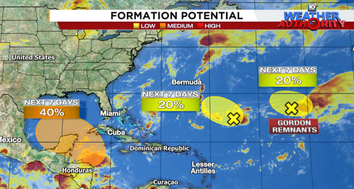
Forecast models continue to advertise slow tropical development beginning next week across the northwestern Caribbean, with a system that could pivot into the southern Gulf of Mexico by the middle to latter part of the week.
Odds of at least a tropical storm (39+ mph winds) moving within 150-200 miles of a given location from next Saturday, September 28th through next Sunday, September 29th, according to the European forecast model ensemble system. Credit: Weathermodels.com.
The verdict’s still out on how much the initially broad area of low pressure and storminess organizes, but the trends since yesterday have been slower and westward with development, with models favoring more land interaction with Central America and southern Mexico which could serve as a temporary speed bump for the first half of next week.
Storminess on the rise
Today we’re starting to see the very early stages of the parent disturbance – a large, sprawling area of storminess and low pressure called the Central American Gyre or CAG – set up from the eastern Pacific into the western Caribbean and southern Gulf.
The CAG will slowly shift westward this weekend and then northward early next week, with lower pressures and more concentrated storminess forming along its northeast flank over the northwestern Caribbean and southern Gulf of Mexico by middle next week.
It’s at this stage – beginning next Wednesday or Thursday – that computer models suggest more earnest development could occur.
Following the forecast trends
The question remains how much development we see from the system given its broad origins and entanglements with southern Mexico and the Yucatán Peninsula. Although the European forecast model and its various scenarios favor a weaker, more strung-out system over the southwestern Gulf next week and the American GFS model and its renditions lean toward a more organized storm farther east over the central Gulf, both camps have generally shifted slower and farther west with development since yesterday.
Forecast low-pressure tracks through next Friday morning, September 27th, from the overnight runs of the European model ensemble system (top) and American GFS model ensemble system (bottom). Each line represents a possible track scenario based on different starting conditions in the model to account for forecast uncertainty. Both forecast camps have trended slower and westward with development since yesterday. The European forecast model continues to favor a weaker system over the southwestern Gulf while the American GFS leans farther east with a more organized storm. It’s important to note that both models continue to show a wide range of possible outcomes, so interests along the entire Gulf Coast should continue to monitor the forecasts. Credit: Weathernerds.org.
While it’s far too early to pinpoint where exactly the system could head next week, the early trends at least have been favorable for South Florida and the far eastern Gulf Coast. That said, it’s still early, and everyone along the Gulf Coast should check back on the forecast trends this weekend and into early next week, as forecast models get a better handle on the future of the system.
It’s worth noting that there are credible outcomes that don’t fully develop a system next week, especially if the Central American Gyre gets mired over southern Mexico. Given the overall conducive environment in the southern Gulf next week, however, any storminess consolidating over water will need to be watched closely as the ceiling is high this time of year.
We’ll have more details on the forecast as they become clearer in the days ahead.
Low development odds over the open Atlantic
Two low-pressure areas over the central Atlantic are being tagged for possible development over the next few days. One of these areas is what remains of once Tropical Storm Gordon and the other has been designated Invest 96L.
The development window is narrow for both and neither poses any threat to land.
Copyright 2024 by WPLG Local10.com – All rights reserved.
Source link : http://www.bing.com/news/apiclick.aspx?ref=FexRss&aid=&tid=66ed817816d14f758b42851c4e1b759f&url=https%3A%2F%2Fwww.local10.com%2Fweather%2Fhurricane%2F2024%2F09%2F20%2Ffollowing-development-trends-for-the-gulf-of-mexico-next-week%2F&c=11004038287871585448&mkt=en-us
Author :
Publish date : 2024-09-20 02:57:00
Copyright for syndicated content belongs to the linked Source.


