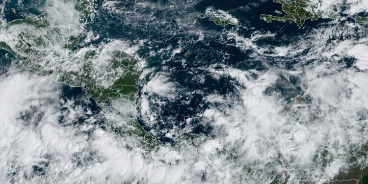
It’s November, the final month of the Atlantic hurricane season, and the active hurricane season of 2024 appears primed to deliver a November named storm — which would be named Patty — in the Western Caribbean. A sprawling low-pressure system known as a Central American Gyre, or CAG, is developing over Central America and the southwestern Caribbean, which will bring heavy rain to portions of Central America. Rainfall in excess of 10 inches (250 mm) over Panama and Costa Rica over the next week could cause dangerous flash flooding and mudslides. The gyre also has the potential to spawn a tropical storm.
Figure 1. Odds of at least a tropical depression (winds of 25+ mph or 40 km/h) moving within 150-200 miles (160-322 km) of a given location for Tuesday, November 5 through Thursday, November 7, according to the 0Z Friday, November 1, run of the European model ensemble. A 75% chance of a tropical depression or tropical storm was indicated over the Western Caribbean (orange colors). (Image credit: Weathermodels.com)
The gyre — a type of monsoon low — is a weak but expansive area of surface low pressure that can persist for two weeks or more across Central America and adjacent parts of the Atlantic and Pacific, including the western Caribbean and southwest Gulf of Mexico. They are most common in May, June, September, October, and November. The gyres often spin off smaller circulations that can become full-fledged tropical cyclones, which can be weak or strong. One such circulation formed in June in the Gulf of Mexico and became the season’s first named storm, Alberto. More seriously, this year’s two catastrophic Gulf of Mexico hurricanes, Helene, and Milton, were both spawned from a CAG.
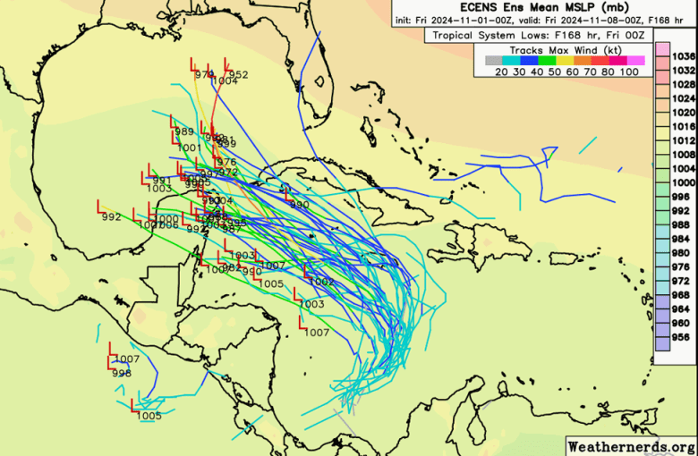
 Figure 2. Track forecasts through Thursday, November 7, from the 0Z Friday, November 1, run of the European ensemble model. Individual forecasts of the ensemble members are the lines color-coded by the wind speed in knots they predict; dark blue colors correspond to a tropical depression or tropical storm (Image credit:Â weathernerds.org)
A Central American Gyre typically takes many days to organize, then once fully developed, several more days to spin off a tropical cyclone. The formation location of a tropical cyclone spun off from a Central American Gyre is very difficult to predict more than two days in advance, but our top forecast models have been persistently predicting that it will spawn the Atlantic’s next named storm – Patty – sometime in the coming week. Conditions are generally favorable for development over the region, with moderate wind shear of 10-20 knots, a moist atmosphere, and sea surface temperatures near 29 degrees Celsius (84°F), which is about 0.5-1.0 degree Celsius above average.
A strong ridge of high pressure to the north of the Caribbean will allow the developing system to drift slowly northward, potentially bringing heavy rains across Jamaica, the Cayman Islands, Cuba, and Haiti in the coming days. The system is likely to turn more to the northwest by Tuesday, which may bring it into the Gulf of Mexico by midweek.
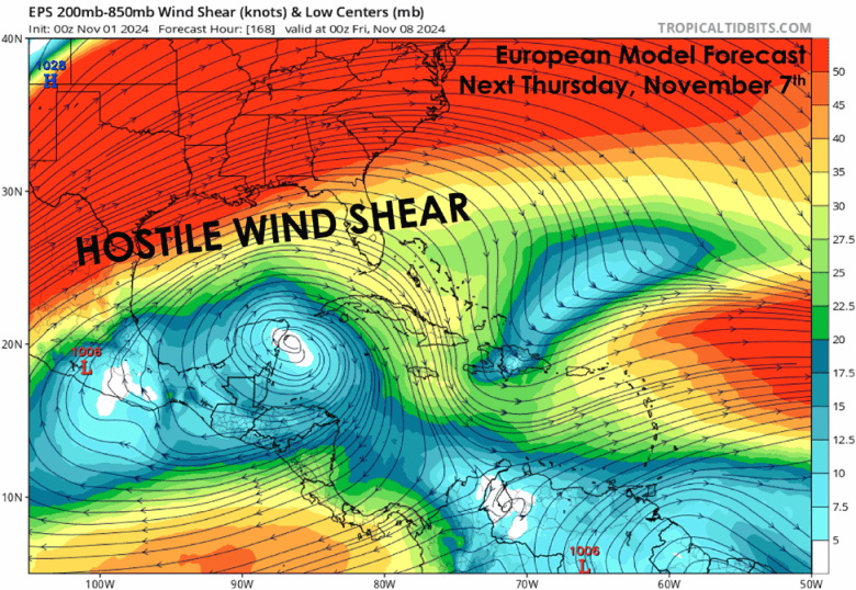
 Figure 3. Wind shear forecast for next Thursday, November 7, from the 0Z Friday, November 1, run of the European ensemble model. A zone of hostile wind shear is predicted to be over the northern Gulf of Mexico, which would significantly weaken any tropical storm that tries to approach the U.S. coast. (Image credit: tropicaltidbits.com, annotated by Michael Lowry in his Friday Substack post).
A hostile environment in the Gulf of Mexico
If wanna-be-Patty does eventually make it into the Gulf of Mexico, it will have an environment much less favorable for development than encountered by Hurricanes Helene and Milton in September and October. Recurring fall cold fronts have spread cool air over the Gulf in recent weeks, causing significant cooling of the waters. More importantly, the jet stream has shifted more to the south and will bring high wind shear accompanied by dry air, making it difficult for a tropical cyclone in the Gulf to intensify (Fig. 3).
In its 8 a.m. EDT Friday Tropical Weather Outlook, the National Hurricane Center gave two-day and seven-day odds of tropical cyclone development in the Western Caribbean of 30% and 70%, respectively. As of Thursday, no Hurricane Hunter missions for this system had been scheduled.
Bob Henson contributed to this post.
Republish This Story
![]()
Republish our articles for free, online or in print, under a Creative Commons license.
Source link : http://www.bing.com/news/apiclick.aspx?ref=FexRss&aid=&tid=6724fe789e7741b696ff97ab1a0c7227&url=https%3A%2F%2Fyaleclimateconnections.org%2F2024%2F11%2Fa-november-tropical-storm-in-the-caribbean-is-now-likely%2F&c=8352670278065595102&mkt=en-us
Author :
Publish date : 2024-11-01 04:46:00
Copyright for syndicated content belongs to the linked Source.


