The population of San Martin grew from about 250,000 in 1970 to more than a million by 2015. The Corredor Interoce├бnico тАУ Norte intersects with the Carretera Marginal de la Selva at the departmental capital of Tarapoto and terminates at Yurimaguas. The landscape between Tarapoto and Yurimaguas is an active colonization zone with the highest deforestation rate in the country. The land rush has now moved to the eastern side of the last Andean ridge and continues to expand across the flat and rolling landscapes adjacent to the Huallaga River below the Pongo de Aguirre.
Oil palm is the lead cash crop, attracting both corporate and smallholder farmers.
PeruтАЩs most active migratory destination is the Department of Madre de Dios, where a gold rush has attracted an estimated 15,000 miners. The total number may be greater, however, since many are temporary migrants who move to the area to seek their fortune or, more likely, obtain a tough job with no benefits. An additional 30,000 individuals, about 35 per cent of the total population, make a living by selling goods and services to the miners. Immigration to Madre de Dios has been greatly facilitated by the construction of the Corredor Interoce├бnico тАУ Sur. The establishment of small farms along the highway is the second-largest cause of deforestation after mining.
PeruтАЩs river network is also a migratory pathway, and there are hundreds of settlements along the Ucayali River and its backwater channels and tributaries. The Peruvian state has yet to finalize the land tenure formalization process, but most families have claimed forty-hectare plots since the colonization process began in the 1960s. Most cultivate annual crops for family consumption, but sell excess produce into the national food market; most also allocate land to pasture and perennial cash crops. Coca is cultivated in small patches along the margin of the forest frontier.
The largest single migratory destination in the Peruvian Amazon is Iquitos, whose history is completely different from that of the other migratory routes. Because Iquitos has no road link to the coast, migrants arrive by river or air. Immigrants have moved to Iquitos in search of jobs in the oil industry or one of the service sectors that dominate the local economy. The city grew rapidly in the 1970s and 1980s following the discovery of oil, which continues to dominate the local economy.
About half the families who have moved to Iquitos are from lowland Ribere├▒o communities and are descendants of Indigenous people who were assimilated into mestizo culture during the rubber boom. Most of the rest have come from the Pacific Coast, particularly Lima. The oil industry requires skilled workers, who can only be provided by universities and trade schools located in large urban centers. Iquitos was still a medium-sized city with a population of 100,000 when oil was discovered in the 1970s along the border with Ecuador. It subsequently grew and, with more than 500,000 inhabitants, is now the largest city in the Western Amazon.
Most residents have settled their families in the city, but many have claimed plots of land in the colonization zone along the highway constructed between Iquitos and Nauta, a town located about 100 kilometers upriver near the junction of the Mara├▒on and Ucayali rivers. Like Leticia in Colombia and Tabatinga in Brazil, Iquitos does not have a terrestrial connection to other population centers. This isolation limited deforestation to the NautaтАУIquitos road; until recently, when a corporation linked to the palm oil industry started clearing forest across the river from Iquitos to establish a cacao plantation.
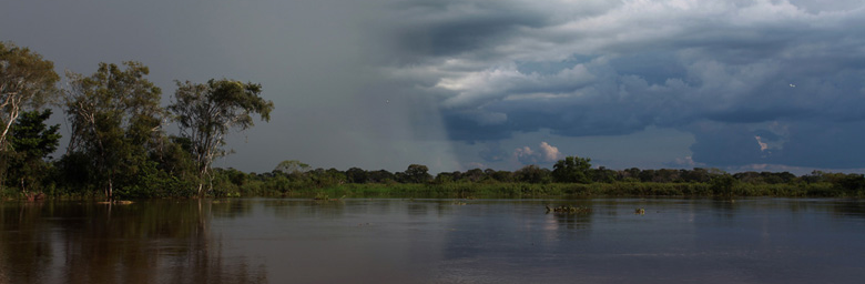
 Water box used for gold mining along the Tambopata River. Image by Rhett A. Butler.
Terror and coca
The other major social and political phenomenon that has impacted the development of PeruтАЩs Amazonian provinces is the cultivation of coca, which is produced in six regions in the eastern foothills of the Andean Cordillera. The expansion of coca for the illicit drug trade began in the upper Huallaga Valley in the 1960s and spread to other parts of the country, particularly the VRAEM (Valley of the Apur├нmac, Ene and Mantaro Rivers) region on the border between Cuzco and Ayacucho and the La Convenci├│n and Lares districts in the Urubamba Valley near the international tourist site of Machu Picchu. These regions became epicenters of the armed conflict perpetrated by two competing insurgencies, the Maoist Sendero Luminoso, or Shining Path, and the Marxist Movimiento Revolucionario Tupac Amaru (MRTA), in the 1980s and early 1990s.
These two groups occupied vast stretches of the rural countryside, and the violence they inflicted on the native population, combined with a harsh response from government forces, led to more than 65,000 deaths. As many as 450,000 individuals were forced to abandon their homes, including approximately 15,000 Ash├бninkas, who either fled their villages and retreated into the forest or were forced into concentration camps by Sendero Luminoso. The violence effectively halted investment by agro-industrial enterprises in the Peruvian Amazon, although the illicit activity stimulated the expansion of coca farms on the forest frontier. The organized violence ended in the mid-1990s, but the government has been unsuccessful in reducing the cultivation of illicit coca. The strategic vision of the Maoist leadership is no longer a factor, but many of the guerilla combatants remain active as criminal actors. Peru continues to produce about thirty per cent of the global supply of illicit cocaine.
The cultivation of coca has been significantly reduced only in the Selva Central and Huallaga Valley. Both of these regions have been the recipients of significant multilateral development assistance, particularly in alternative production strategies such as coffee, cocoa and palm oil, as well as in improved health and education facilities. Not incidentally, both regions are part of IIRSA-sponsored infrastructure projects that have greatly facilitated the connection of their producers with domestic and global markets. In contrast, the landscapes that have continued to embrace coca production remain relatively isolated from the national economy.
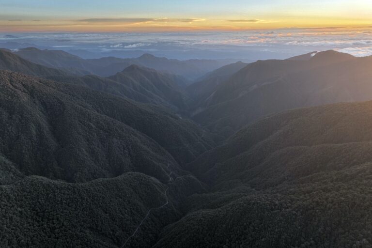
Banner image: Panoramic view from Wayqecha Biological Station, located near the transition between the cloud forest and puna of the Cusco region. Credit: Rhett A. Butler.
тАЬA Perfect Storm in the AmazonтАЭ is a book by Timothy Killeen and contains the authorтАЩs viewpoints and analysis. The second edition was published by The White Horse in 2021, under the terms of a Creative Commons license (CC BY 4.0).
To read earlier chapters of the book, find Chapter One here, Chapter Two here, Chapter Three here, Chapter Four here and Chapter Five here.
Chapter 6. Culture and demographic defines the present
┬а
![]()
Source link : http://www.bing.com/news/apiclick.aspx?ref=FexRss&aid=&tid=675abe3b8d0f4ef5a4d30df93dd1e2cf&url=https%3A%2F%2Fnews.mongabay.com%2F2024%2F12%2Fperus-modern-history-of-migration-and-settlement%2F&c=6435292264723526237&mkt=en-us
Author :
Publish date : 2024-12-11 21:20:00
Copyright for syndicated content belongs to the linked Source.


