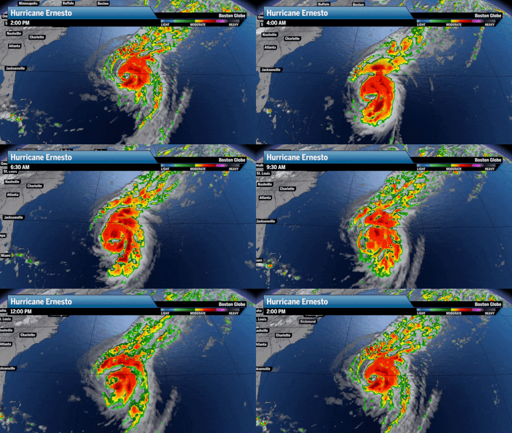
Right now, all signs point to Ernesto missing New England well to the east.
Hurricane Ernesto holds 100 mph maximum sustained winds and remains on track to strike Bermuda on Saturday.Boston Globe
The mid-level winds help dictate tropical system paths тАФ and a steady northwesterly wind should help Ernesto stay away from the East Coast. A semi-permanent high-pressure system living over the northern Atlantic to the northeast of ErnestoтАЩs current position and a relatively strong high pressure system situated over the southeast and Gulf of Mexico has prevented Ernesto from progressing west.
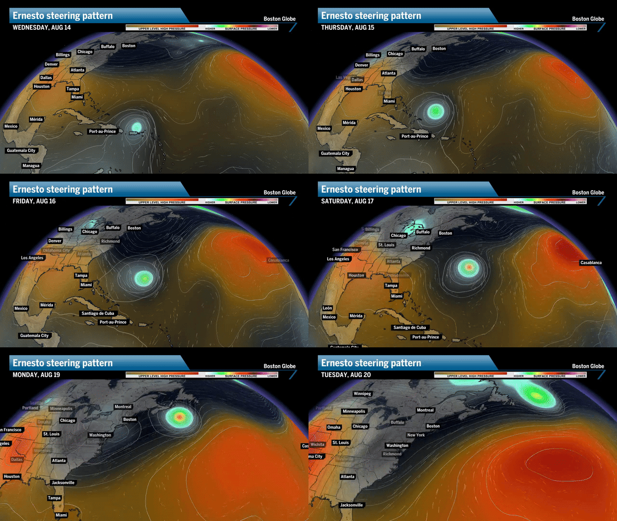 Two pockets of high pressure in orange to the west and east of Ernesto will drive the system north тАФ┬аa northwest pattern from the Great Lakes and Northeast should help push Ernesto away from the coast.Boston Globe
What New England can expect
Large swells and dangerous rip currents are a few things the East Coast can expect to see.
Rough seas and high surf ahead
Beachgoers may second guess jumping into the ocean this weekend and early next week with Ernesto likely to reach Bermuda as a Category 3 storm, packing sustained winds of 111 to 129 miles per hour. Winds this strong can produce huge waves that can travel a few thousand miles.
With coastal Southern New England between 575 and 800 nautical miles away from the island country, New England can expect high surf this weekend тАФ producing rip currents that can be exceptionally dangerous to swimmers. Waves may reach as high as 4 to 8 feet along parts of the New England coast.
тАЬRisk of life-threatening surf and rip currents is expected to increase along the US East Coast beaches this weekend,тАЭ the National Hurricane Center warned in declaring Ernesto a hurricane this morning.
Hurricane #Ernesto Advisory 16A: Hurricane Ernesto Expected to Be Near Bermuda On Saturday. High Risk of Dangerous Rip Currents Along U. S. East Coast Beaches This Weekend. https://t.co/tW4KeGe9uJ
тАФ National Hurricane Center (@NHC_Atlantic) August 15, 2024
Warm enough waters to sustain storms in northern latitudes
It remains to be seen how long Ernesto will last after passing Bermuda, but the environment may be conducive for a Canadian landfall across the northeast portions of Nova Scotiva.The general rule regarding sea surface temperatures and tropical system formation and sustainability is that ocean temperatures need to be at least 79 degrees.
The average sea surface temperature across the entire Northern Atlantic, stretching from the equator to 60 degrees north latitude тАФ approximately the southernmost tip of Greenland or Anchorage, Alaska.
Check out the map below and notice how average temperatures are nearly around 26 degrees Celsius, which is 78.8 degrees Fahrenheit. Of course this is the average тАФ sea surface temperatures are generally more hot the closer you get to the equator.
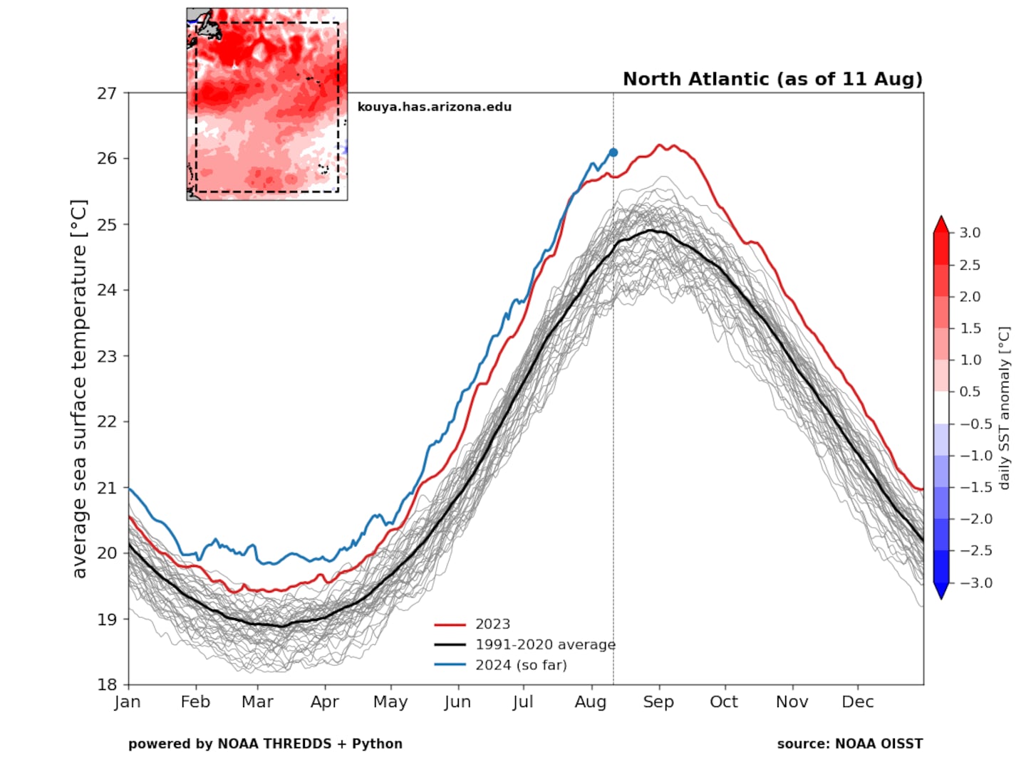 The average sea surface temperature across the northern Atlantic is setting daily record highs in August тАФ reaching over 26 ┬░C (79┬░F).Dr. Kim Wood
You can see the difference in sea surface temperatures across the Atlantic Ocean below, with temps high enough to support tropical systems shortly to the south and southeast of New England.
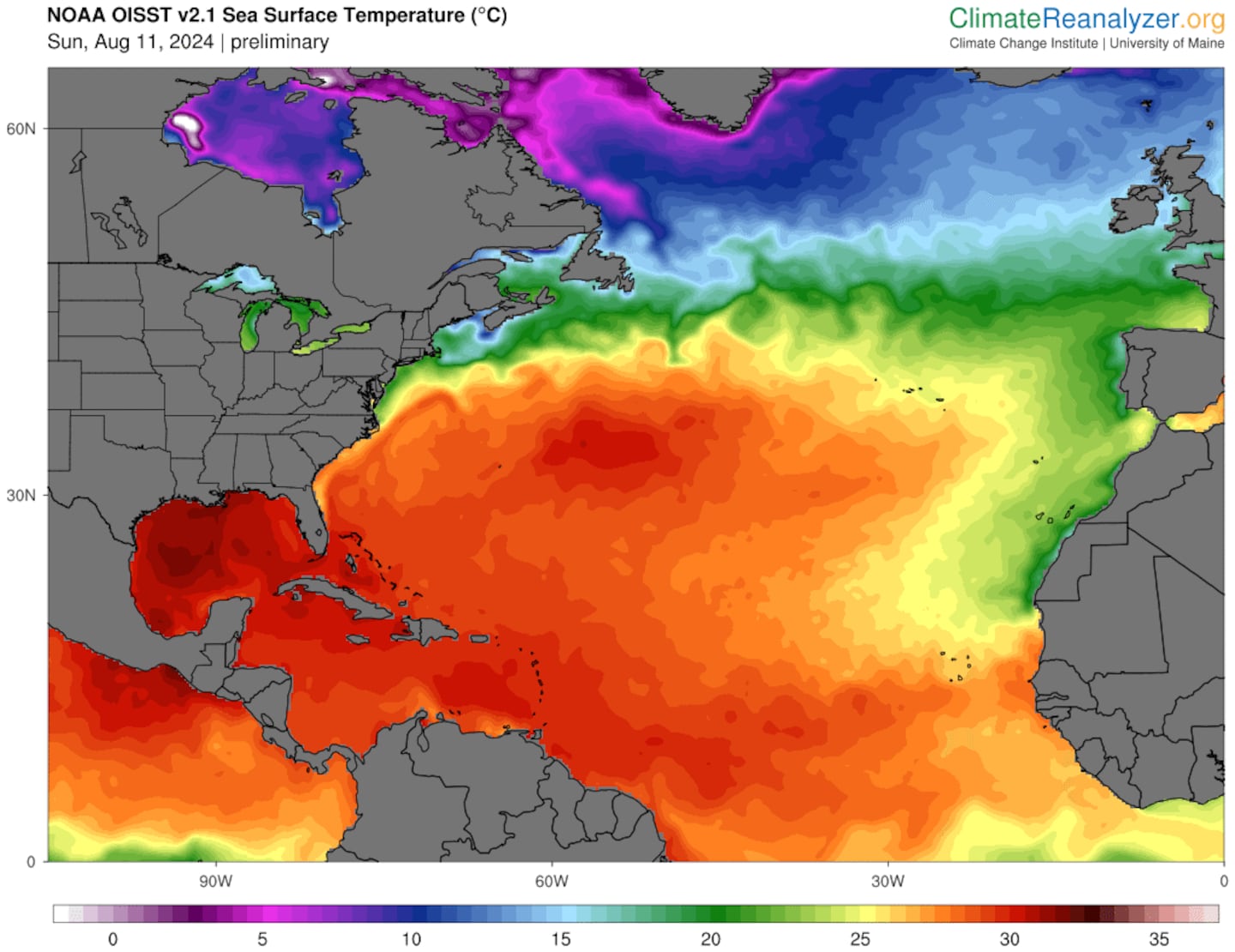 Very warm water persists just south and southeast of New England, where the yellow and orange indicate sea surface temperatures suitable to keep tropical systems intact.Climate Reanalyzer
Sea surface temperatures are currently averaging 1 to 3 degrees warmer than average across waters between Bermuda and New England. The Gulf stream is a major component to this, delivering exceptionally warm water into the northern East Coast.
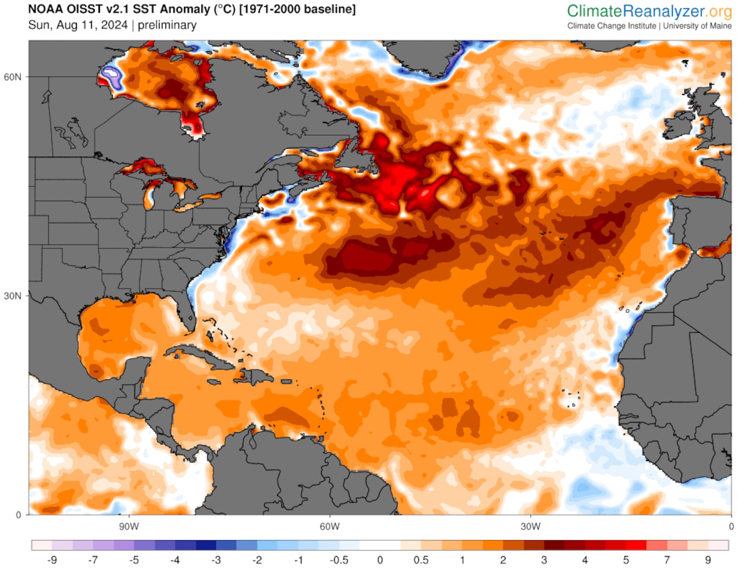 Sea surface temperatures across the Northern Atlantic continue to be 1 to 3 degrees above average. Very warm waters near Bermuda may keep Ernesto a hurricane for longer.Climate Reanal
And keep in mind, tropical storms and hurricanes weaken more gradually when moving into cooler waters versus over land, prolonging the stormтАЩs life.
The strongest hurricane to make landfall in Canada was in 1963, when Hurricane Ginny reached near Yarmouth as a Category 2 storm with winds of 105 miles per hour.
With sea surface temperatures and ocean heat content peaking in the coming weeks, it will be worth monitoring how far north storms may reach before breaking down.
Ocean heat content measures how much heat is stored in the ocean or, in other words, how deep warmer-than-average temperatures go in the ocean тАФ which is also measuring exceptionally warmer than normal. This is another indicator of a changing climate, with more heat across sea surfaces and into the depths.
Interesting Ernesto tidbits
A couple of quick stats: This is the eighth time that a tropical storm has been named Ernesto, with the strongest growing into Hurricane Ernesto in 2012 that made landfall in eastern Mexico after traversing through the Caribbean.
Ernesto has also formed 10 days ahead of the normal hurricane schedule. The fifth-named storm of the season usually does not form until Aug. 22.
Sign up here for our daily Globe Weather Forecast that will arrive straight into your inbox bright and early each weekday morning.
Ken Mahan can be reached at [email protected]. Follow him on Instagram @kenmahantheweatherman.
Source link : https://www.bostonglobe.com/2024/08/14/metro/ernesto-storm-track-new-england-east-coast-hurricane/
Author :
Publish date : 2024-08-16 01:24:00
Copyright for syndicated content belongs to the linked Source.

