Hurricane recovery forecast in Florida and North Carolina
As recovery efforts continue from Helene and Milton throughout the Southeast, here’s a breakdown of how this week’s weather will affect everyone involved.
There’s good news when it comes to the tropics: Even though the National Hurricane Center is tracking two invests, neither seem to be a threat to Florida at this time.
Invest 94L, which flirted earlier this week with the potential to develop into Tropical Storm Nadine, is expected to impact Puerto Rico and Hispaniola with flooding rain.
Invest 95L, which is showing potential of becoming a short-lived tropical depression or even Tropical Storm Nadine, could bring the same conditions to Central America and Mexico Saturday, according to the latest advisory from the National Hurricane Center.
➤ Track all active storms
➤ Weather alerts via text: Sign up to get updates about current storms and weather events by location
Even better news for those recovering from hurricanes Helene and Milton: No tropical development is expected over the next 10 days, according to the latest two-week forecast from Colorado State University meteorologists.
The next named storms of the season will be Nadine and Oscar.
‘Hints’ are there for tropical development in western Caribbean later this month
In its two-week forecast, Colorado State University meteorologists said there is a 50% chance for tropical development over the next two weeks, from Oct. 15 through Oct. 28.
There’s nothing out there now and chances for development of Invests 94L and 95L are fairly low.
However, “There are hints of potential additional development in the western Caribbean late in the forecast period, but these signals are fairly weak,” CSU forecasters said.
➤ WeatherTiger: A hurricane season treat, but beware chance of one last hellish trick from Mother Nature
“Wind shear anomalies are forecast to be somewhat below normal during the two-week period in the Caribbean, so we believe that there is additional potential for tropical cyclone formation in the Caribbean.”
A similar forecast was issued by Dr. Ryan Truchelut, chief meteorologist with WeatherTiger.
“I am confident that the next week and a half will be free of the conepanics associated with tropical threats to the continental United States,” Truchelut said. “However, at longer range, hurricane season is not over.” Truchelut is a Florida meteorologist who works with the USA TODAY Network.
“There are solid indications that of a couple of weeks of unusually favorable upper-level winds are coming to the Caribbean starting at the very end of October and extending through mid-November.
“With the Caribbean Sea still blazing hot, it’s possible that one or two more named storms could be squeezed out of this set-up. That’s not to say that these would be U.S. landfall threats — history suggests they wouldn’t be — but it’s worth keeping an eye on the Oct. 30 through Nov. 10 window, just in case.”
Late-season hits from major hurricanes unusual for Florida
The latest Florida Category 3+ landfall, the 1921 Tarpon Springs hurricane, occurred on Oct. 25, and a major hurricane has never struck anywhere in the U.S. after Oct. 28, Truchelut said.
“Only about 2% of annual U.S. landfall activity occurs beyond that date: about 20 storms in around 170 years, seven of which were hurricanes. Most late season landfalls are focused on South Florida, with Category 2 Hurricane Kate in the Panhandle a notable exception.”
Here’s the latest update from the NHC as of  2 p.m. Oct. 18: Â
Where is Invest 94L and where is it going?
Invest 94L: Recent satellite-derived wind data indicate that a trough of low pressure continues to produce showers and thunderstorms extending a couple hundred miles north of Puerto Rico and the Virgin Islands.
Development, if any, of this disturbance should be slow to occur while it moves quickly westward to west-northwestward at around 20 mph, continuing north of Puerto Rico and the Virgin Islands today, then near Hispaniola and the southeastern Bahamas this weekend.
Further development is not expected due to strong upper-level winds by early next week.
➤ Track Invest 94L
Formation chance through 48 hours: low, 20 percent.Formation chance through 7 days: low, 20 percent.
Impacts: Torrential rain and gusty winds will threaten many of the islands in the northern Caribbean from late this week to next week, according to AccuWeather.
Northeasterly winds are helping push anything that could develop away from Florida but those same winds could bring rough surf, beach erosion and coastal flooding to Florida’s east coast, AccuWeather said.
Invest 94L spaghetti models
Special note about spaghetti models:Â Illustrations include an array of forecast tools and models, and not all are created equal. The hurricane center uses only the top four or five highest performing models to help make its forecasts.Â
Where is Invest 95L and where is it going?
Invest 95L: Widespread showers and thunderstorms have become a little better organized today across the northwestern Caribbean Sea in association with a broad area of low pressure that is gradually becoming betterdefined to the north of eastern Honduras.
Environmental conditions appear conducive for some additional development over the next day or so, and a short-lived tropical depression or storm could form before the system moves inland over Central America on Saturday.
Residents in Belize and the Yucatan Peninsula of Mexico should monitor the progress of this system, as tropical storm watches or warnings may be required later today.
➤ Track Invest 95L
Formation chance through 48 hours: high, 70 percent.Formation chance through 7 days: high, 70 percent.
Impacts: Regardless of development, locally heavy rainfall is likely across portions of Central America and southern Mexico through the weekend, according to the National Hurricane Center.
Invest 95L spaghetti models
Special note about spaghetti models:Â Illustrations include an array of forecast tools and models, and not all are created equal. The hurricane center uses only the top four or five highest performing models to help make its forecasts.Â
What is an invest?
Short for investigation, the National Hurricane Center uses the term invest for areas of low pressure it is monitoring for potential development into a tropical depression or storm.
Invests are not tropical depressions or tropical storms. They’re usually clusters of showers and thunderstorms, and just because they’ve been designated as an invest does not guarantee they’ll develop into a tropical cyclone.
Invests run from 90 to 99, followed by a letter: L for the Atlantic basin and E for those in the eastern Pacific. After 99, it starts over again and the next invest would be 90.
Once something has been designated as an invest,  specialized data sets and computer models can begin, including scheduling Hurricane Hunter aircraft missions and running spaghetti models.
What else is the National Hurricane Center tracking?
The National Hurricane Center is tracking no other disturbances in the Atlantic basin, which includes the northern Atlantic, Caribbean Sea and Gulf of Mexico.
What do the colored areas on the NOAA map mean?
The hatched areas on a tropical outlook map indicate “areas where a tropical cyclone — which could be a tropical depression, tropical storm or hurricane — could develop,” said National Hurricane Center Deputy Director Jamie Rhome.
The colors make it visibly clear how likely a system could develop with yellow being low, orange medium and red high.
The National Hurricane Center generally doesn’t issue tropical advisories until a there is a named storm, but there is an exception.
“If a system is near land and there is potential for development, the National Hurricane Center won’t wait before it issues advisories, even if the system hasn’t become an actual storm. This gives residents time to prepare,” Rhome said.
Weather watches and warnings issued in FloridaWhen is the Atlantic hurricane season?
The Atlantic hurricane season runs from June 1 through Nov. 30.
The Atlantic basin includes the northern Atlantic Ocean, Caribbean Sea and Gulf of Mexico.
Countdown clock: When will 2024 Atlantic hurricane season end?When is the peak of hurricane season?
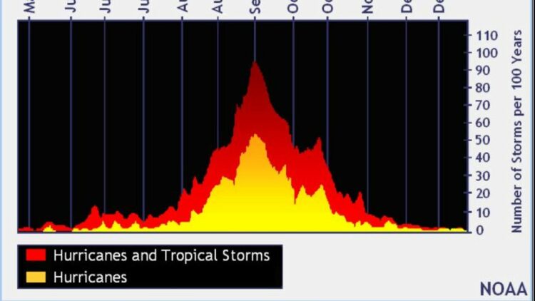
The peak of the season is Sept. 10, with the most activity happening between mid-August and mid-October, according to the Hurricane Center.
Interactive map: Hurricanes, tropical storms that have passed near your cityStay informed. Get weather alerts via textWhat’s next?Â
We will continue to update our tropical weather coverage daily. Download your local site’s app to ensure you’re always connected to the news. And look for our special subscription offers here.Â
(This story was updated to add new information.)
Source link : http://www.bing.com/news/apiclick.aspx?ref=FexRss&aid=&tid=6713518d49eb45f289e2b393cafa4aed&url=https%3A%2F%2Fwww.palmbeachpost.com%2Fstory%2Fweather%2Fhurricane%2F2024%2F10%2F18%2Ftropics-update-tropical-storm-nadine-invest-94l-95l%2F75737678007%2F&c=9925159762261055507&mkt=en-us
Author :
Publish date : 2024-10-18 04:37:00
Copyright for syndicated content belongs to the linked Source.


