
![]()

AccuWeather’s 2024-2025 winter forecast
Will it be a cold and snowy winter? Lincoln Riddle spoke with AccuWeather’s long-range experts to find out.
The National Hurricane Center is tracking a tropical disturbance it has dubbed Invest 94L as it moves its way toward the Leeward Virgin Islands late this week, though the center has slightly dialed back the disturbance’s chances of becoming Tropical Storm Nadine.
Meanwhile, the NHC is also tracking another tropical wave in the western Caribbean Sea that has even lower odds of forming before it’s expected to veer westward into Central America.
The good news for Floridians who have been hit by back-to-back hurricanes is that neither tropical feature is expected to have much impact on the Sunshine State.
Northward paths for both storms remain relatively blocked, according to AccuWeather. However, if one of the systems were to have a possibility of impacting Florida, Invest 94L is the one to keep an eye on.
Florida’s winter forecast: Expect warm, dry winter with heightened risk of severe weather
“It is possible for the feature to ramp up quickly to a tropical depression or tropical storm as its core approaches or passes near the Leewards late this week,” AccuWeather Lead Hurricane Expert Alex DaSilva said, “But, as this system travels farther to the west, whatever it becomes, could run into more hostile conditions for strengthening and organization.”
The larger islands of the northern Caribbean will act as physical obstacles the system is unlikely to endure as it attempts to pass over the area over the weekend, and a “complex weather pattern” will also deter the storm from continuing north.
Florida residents should still keep a watchful eye on the system over the coming days as any shift in positioning or strengthening could change things.
Here’s the latest tropics news.
Tropical disturbance Invest 94L less likely to become Tropical Storm Nadine
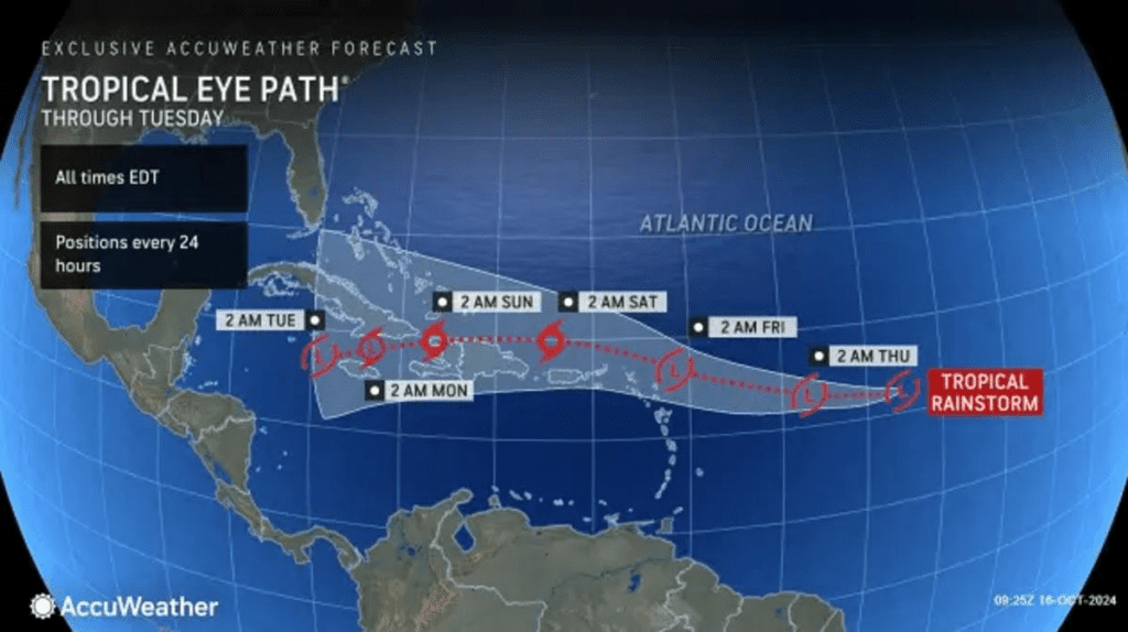
Invest 94L has the best odds of becoming Tropical Storm Nadine as it could develop into a tropical depression as the system moves near the Leeward and Virgin Islands late this week.
The NHC gave Invest 94L a low chance of tropical cyclone development through the next 48 hours and a medium chance for development in the next seven days, slightly downgrading its chances from Monday.
It will move generally westward over the next several days where environmental conditions like low wind shear and warm water could lead to gradual development by the middle to latter part of the week.
Regardless of how Invest 94L shapes up, it’s worth keeping an eye on if you live along the Florida Gulf Coast.
“It is possible for the feature to ramp up quickly to a tropical depression or tropical storm as its core approaches or passes near the Leewards late this week,” DaSilva said, “But, as this system travels farther to the west, whatever it becomes, could run into more hostile conditions for strengthening and organization.”
Tropical disturbance Invest 94L pathInvest 94L spaghetti modelsWestern Caribbean tropical disturbance still slated to push into Central America
Hints of the second tropical disturbance appeared Monday and continues to grow in response to a gyre, a large and slowly rotating area of low pressure. It’s the same gyre that produced the likes of hurricanes Helene and Milton.
AccuWeather says that this feature will likely be a more southern one, saying a northward path is currently blocked and should stay blocked.
While the system isn’t expected to impact the United States directly, some of its remnant energy could survive and spur new development in the eastern Pacific, which AccuWeather says could spur development in the western Caribbean or the eastern Pacific in the coming days.
Will the western Caribbean tropical disturbance or Invest 94L impact Florida?
Probably not.
Florida still appears to be shielded from both tropical disturbances, according to AccuWeather.
“The first is the larger islands of the northern Caribbean, such as Puerto Rico and Hispaniola. The tall mountains could rip away at any system that tracks overhead,” said AccuWeather. “The other factor is a complex weather pattern, including the jet stream setup over the southern Atlantic Ocean, the eastern Gulf coast of the U.S. and over the Bahamas.”
When would Florida see any impacts from the tropical disturbances?
Impacts to Florida, if any, won’t be felt until early next week at the earliest, according to AccuWeather.
What are the next two hurricane names?
Nadine and Oscar are the next two names on the list of hurricane names for the 2024 season.
When will the 2024 Atlantic hurricane season end?
Source link : http://www.bing.com/news/apiclick.aspx?ref=FexRss&aid=&tid=6710220ac22444c7ab2d405ad701df8f&url=https%3A%2F%2Fwww.pnj.com%2Fstory%2Fweather%2Fhurricanes%2F2024%2F10%2F16%2Fwill-invest-94l-become-nadine-national-hurricane-center-lowers-odds%2F75700417007%2F&c=2635710737450979075&mkt=en-us
Author :
Publish date : 2024-10-16 04:49:00
Copyright for syndicated content belongs to the linked Source.