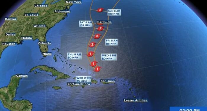
At 500 PM AST (2100 UTC), the center of Hurricane Ernesto was located near latitude 21.7 North, longitude 68.3 West. Ernesto is moving toward the northwest near 16 mph (26 km/h). A turn toward the north-northwest and north is expected tonight and on Thursday. A northward to northeastward motion at a slower forward speed is expected Friday and Saturday. On the forecast track, the center of Ernesto is expected to pass near Bermuda on Saturday.
Maximum sustained winds are near 75 mph (120 km/h) with higher gusts. Strengthening is forecast during the next couple of days, and Ernesto could become a major hurricane by Friday.
Hurricane-force winds extend outward up to 35 miles (55 km) from the center and tropical-storm-force winds extend outward up to 175 miles (280 km).
The estimated minimum central pressure is 989 mb (29.21 inches).
Tropics Satellite at 7:11 Wednesday Evening, August 14thWatches and Warnings
CHANGES WITH THIS ADVISORY:
The Bermuda Weather Service has issued a Hurricane Watch for Bermuda.
SUMMARY OF WATCHES AND WARNINGS IN EFFECT:
A Hurricane Watch is in effect for, * Bermuda
A Hurricane Watch means that hurricane conditions are possible within the watch area. A watch is typically issued 48 hours before the anticipated first occurrence of tropical-storm-force winds, conditions that make outside preparations difficult or dangerous.
For storm information specific to your area, please monitor products issued by your national meteorological service.
Tropics Models at 7:10 Wednesday Evening, August 14thLand Hazards
Key messages for Ernesto can be found in the Tropical Cyclone Discussion under AWIPS header MIATCDAT5 and WMO header WTNT45 KNHC and on the web at hurricanes.gov/text/MIATCDAT5.shtml.
WIND: Hurricane conditions are possible on Bermuda Saturday, with tropical storm conditions possible by Friday afternoon.
RAINFALL: Ernesto is expected to produce total rain accumulations of 3 to 6 inches on Bermuda with isolated maximum amounts of 9 inches. This rainfall may result in considerable life-threatening flash flooding.
Rainfall is expected to diminish this evening across Puerto Rico and the U.S. And British Virgin Islands. Total rainfall amounts from Ernesto are expected to be in the 6 to 10 inch range, with maximum amounts of 12 inches across southern to eastern Puerto Rico, 3 to 6 inches across northwestern Puerto Rico, and 4 to 6 inches across the U.S and British Virgin Islands.
For a complete depiction of forecast rainfall associated with Hurricane Ernesto, please see the National Weather Service Storm Total Rainfall Graphic, available at hurricanes.gov/graphics_at5.shtml?rainqpf
SURF: Swells generated by Ernesto are affecting portions of the northern Leeward Islands, the Virgin Islands, Puerto Rico, the Dominican Republic, and the Turks and Caicos Islands. These swells will reach the southeastern Bahamas tonight, and Bermuda and the rest of the Bahamas on Thursday. Swells are expected to reach the east coast of the United States Thursday night and continue into the weekend. These swells are likely to cause life-threatening surf and rip current conditions. Please consult products from your local weather office.
Source link : http://www.bing.com/news/apiclick.aspx?ref=FexRss&aid=&tid=66bd3aa9a1ff43f58e8775fdb5402587&url=https%3A%2F%2Fwww.news4jax.com%2Fweather%2Fhurricane%2F2024%2F08%2F11%2Ftropical-storm-watches-issued-for-portions-of-the-leeward-islands%2F&c=5730420541626853252&mkt=en-us
Author :
Publish date : 2024-08-11 13:53:00
Copyright for syndicated content belongs to the linked Source.


