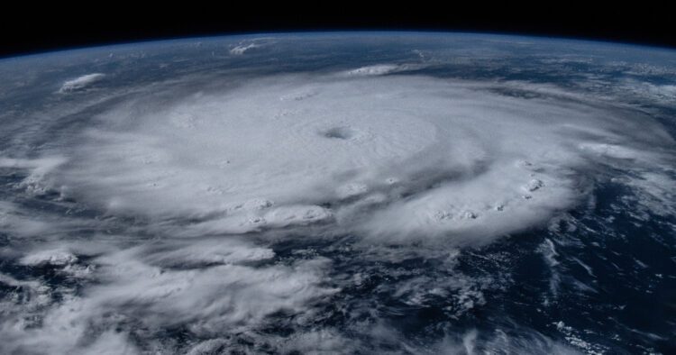
The International Space Station captured stunning images of Hurricane Beryl on Monday, currently a Category 5 storm on the Saffir-Simpson scale. These images vividly illustrate the massive scale of this powerful atmospheric phenomenon as it moves through the Caribbean Sea.
Through its account on the social media platform X, the space center showcased the enormity of the storm, which has placed several Caribbean islands on high alert. The hurricane has already left a trail of destruction in Grenada, Barbados, Saint Vincent and the Grenadines, and Saint Lucia, among other areas in the Lesser Antilles.
The astronauts aboard the space station were able to observe the eye of the hurricane, and one of them, Matthew Dominick, seized the opportunity to share photos of Beryl.
Hurricane Beryl’s Impact and Projections
According to the National Hurricane Center (NHC), as of 8:00 AM AST (12:00 UTC), the eye of the hurricane was located approximately 485 kilometers (km) southeast of Isla Beata, Dominican Republic, and 1005 km from Kingston, Jamaica. The maximum sustained winds are 270 km/h, with the storm currently moving west-northwest at 35 km/h.
There is currently a hurricane warning in effect for Jamaica, Grand Cayman, Little Cayman, and Cayman Brac. Additionally, a tropical storm warning is in place for the southern coast of the Dominican Republic from Punta Palenque westward to the border with Haiti, and the southern coast of Haiti from the Dominican border to Anse d’Hainault.
Forecasts indicate that the hurricane will continue to move through the Caribbean with strong winds along its path. Projections show that Cuba will be among the affected areas, although winds there are not expected to exceed 63 km/h.
This marks the first time in history that a storm of this magnitude has occurred so early in the year. Meteorologists agree that this cyclonic system is the most powerful hurricane ever recorded so early in the Atlantic, surpassing Dennis in 2005 by a week.
Frequently Asked Questions about Hurricane Beryl
Here are some common questions and answers regarding the current status and impact of Hurricane Beryl.
Where was Hurricane Beryl located as of the latest update?
As of the latest update, the eye of Hurricane Beryl was located approximately 485 kilometers southeast of Isla Beata, Dominican Republic, and 1005 kilometers from Kingston, Jamaica.
What areas are under a hurricane warning?
The areas currently under a hurricane warning include Jamaica, Grand Cayman, Little Cayman, and Cayman Brac.
How strong are the winds associated with Hurricane Beryl?
Hurricane Beryl has maximum sustained winds of 270 km/h.
What makes Hurricane Beryl historically significant?
Hurricane Beryl is historically significant because it is the most powerful hurricane ever recorded so early in the Atlantic season, surpassing Dennis from 2005 by a week.
Source link : https://www.cubaheadlines.com/articles/284484
Author :
Publish date : 2024-07-02 14:03:09
Copyright for syndicated content belongs to the linked Source.


