Migration into Meta and Guaviare in the 1990s and 2000s was almost entirely linked to the production of coca leaf and efforts by the FARC and other militias to extend their influence over the landscapes at the edge of the agricultural frontier. Successive waves of peasant settlers have occupied the landscapes surrounding Parque Nacional Natural Sierra de la Macarena, which the FARC has used as a staging area and refuge since the 1960s.
Their operational tactics changed in the 1980s, when they embraced the illicit drug trade as a source of revenue and actively protected peasant farmers growing coca leaf. Roads did not exist in the forest frontier, nor was it advantageous for coca growers to colonize landscapes accessible by vehicular transport. Consequently, the coca growers and the influence of the FARC expanded by using forest trails and river networks.
The peace process has radically changed this dynamic. Land speculators are financing the relocation of small farmers, who are encouraged to тАШmove onтАЩ as their original holdings are consolidated into cattle farms that are now accruing value as the region opens to investment. The central government hopes to limit development in the buffer zones around both Macarena and Chiribiquete national parks, and has limited its infrastructure investment to a limited number of major arteries; however, the local officials and land speculators have been building secondary and tertiary roads at an alarming rate.
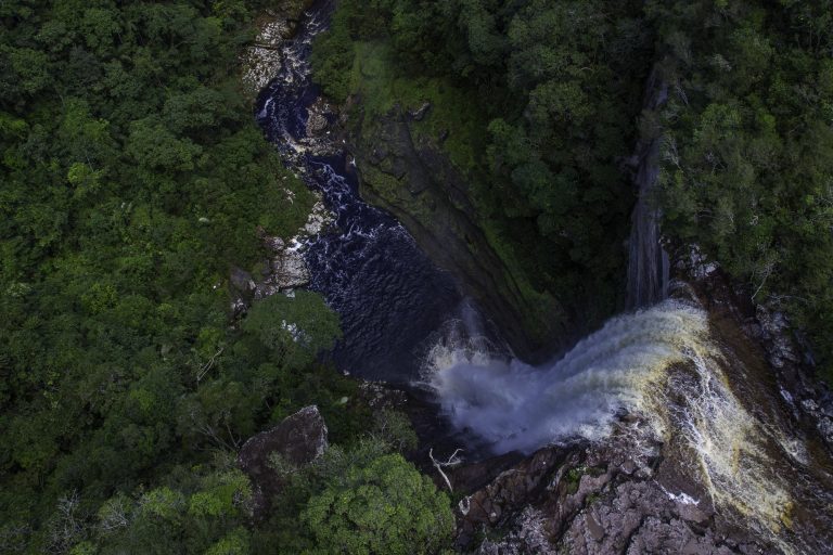 Chiribiquete supplies 60% of the surface water in the entire Colombian Amazon. Image courtesy of the National Natural Parks System of Colombia.
Venezuela and the Guianas
Successive Venezuelan governments have viewed the natural resources of the Guiana Shield as an economic asset that should be used for national development. This strategy was formulated in the mid-twentieth century and led to the creation of a state-owned enterprise, the Corporacion Venezolana de Guayana (CVG), to develop mineral and hydrological resources. This decentralized, state-owned conglomerate was established in the 1960s and created a variety of subsidiaries dedicated to the mining and processing of iron ore and steel, bauxite and aluminum, and the development of coal and hydropower energy. The stateтАЩs presence was further consolidated in the early 1970s, when President Rafael Caldera (1969тАУ1974, 1994тАУ1999) built a modern highway through the southeastern Gran Sabana region to connect with BR-174, which linked Venezuela with the Brazilian Amazon.
Originally, most of the CVG subsidiaries were efficient producers and competed successfully in international mineral markets; however, their viability as business enterprises declined as their mines aged, industrial assets depreciated and national competitiveness eroded because of mismanagement. The administrations of President Hugo Ch├бvez (1999тАУ2013) and his successor, President Nicol├бs Maduro (2013тАУpresent) bankrupted most of these state-owned business enterprises. Nevertheless, migration into the region has continued because of the allure of the ongoing gold rush, facilitated by the military authorities who now oversee development in the southeastern state of Bol├нvar.
Guyana and Suriname are coastal countries with historical and cultural ties to the island nations of the Caribbean. Economically they are very dependent on their mineral resources, and they apparently view their Amazonian territories as a natural resource to be exploited when opportunities present. Neither country has designated large areas for protection, and their indigenous territorial systems are relatively small. Most land is held in an unallocated forest reserve. The government of Guyana recently has sought to develop an international transport corridor that would link the emerging agricultural landscapes in Roraima, Brazil, with port facilities in Georgetown. This could change the land-use dynamic along that road as settlers create outposts to provide key services to the transport sector.
The borders among Guyana, Suriname and French Guiana have been managed diplomatically among the colonial powers and the independent states that succeeded them. None of these states seems genuinely interested in colonizing their interior provinces. The border between Venezuela and Guyana is the only remaining contested terrestrial border in the Western Hemisphere. The long-simmering dispute over GuyanaтАЩs mineral-rich Essequibo region, which never led to armed conflict, flared up again following the 2015 discovery of an offshore oil deposit potentially worth hundreds of billions of dollars.
 The floodplains of the Andean piedmont and certain geologically defined landscapes on the Brazilian and Guiana Shield attract tens of thousands of wildcat miners, who employ placer mining technology that is particularly destructive and extraordinarily toxic. Credit: IBAMA & Vincius Mendon├зa, CC BY-SA 2.0, Flickr.com Ryan M. Bolton, Shutterstock.
Migratory pathways
The Guiana Shield has escaped the large-scale settlement and deforestation that characterize both Amazonian Brazil and Andean countries. This does not mean, however, that it has not been impacted by migration. The region is home to tens of thousands of wildcat gold miners exploiting mineral resources in the thinly populated hinterlands of Venezuela, Guyana, Suriname and French Guiana. These miners are a combination of local inhabitants and fortune-seeking immigrants, mainly Brazilian, whose numbers fluctuate in response to changes in the price of gold. The Suriname government estimates the country has about 20,000 small-scale mining operations, each of which probably employs between five and ten individuals. Most mine owners are native-born Maroons who employ thousands of Brazilian garimpeiros.
It is difficult to know precisely what is transpiring in Venezuela because of the chaotic governance that has characterized the country for the last decade. According to 2011 national census, the municipality of Sifontes had a population of 51,000, but recent reports suggest that this number may have surged to more than 400,000 by 2016. The gold mining region is controlled by the military, which operate numerous mines via joint ventures with Venezuelan businesspeople.
Many of these immigrants may not be gold miners, however, but individuals importing scarce goods from Brazil or seeking to emigrate. At the end of 2022, approximately 70,000 Venezuelans were living in Roraima and Amazonas, with some 33,000 in makeshift shelters and camps. Most, if not all, survive by working in the informal economy.
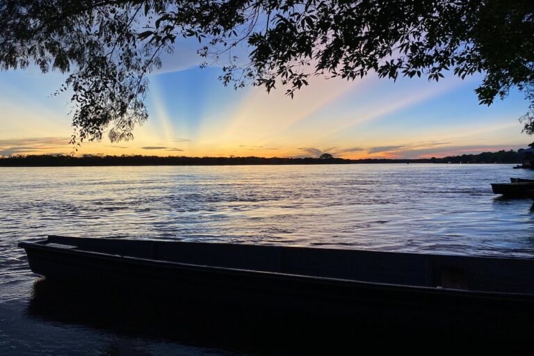
Banner image: A canoe of Indigenous design in Colombia. Image by J.J. Javier via Nia Tero.
тАЬA Perfect Storm in the AmazonтАЭ is a book by Timothy Killeen and contains the authorтАЩs viewpoints and analysis. The second edition was published by The White Horse in 2021, under the terms of a Creative Commons license (CC BY 4.0).
To read earlier chapters of the book, find Chapter One here, Chapter Two here, Chapter Three here, Chapter Four here and Chapter Five here.

Chapter 6. Culture and demographic defines the present
┬а
![]()
Source link : http://www.bing.com/news/apiclick.aspx?ref=FexRss&aid=&tid=676ee246f54e426f9524d87b4cecf3a6&url=https%3A%2F%2Fnews.mongabay.com%2F2024%2F12%2Fthe-particularities-of-the-migratory-movement-in-venezuela-the-guianas-and-suriname%2F&c=16916332380175556203&mkt=en-us
Author :
Publish date : 2024-12-27 04:03:00
Copyright for syndicated content belongs to the linked Source.


