
ShareA surprising hurricane season – and lots of activity in the Gulf Coast
This Atlantic hurricane season hasn’t shaped up like experts predicted.
In May, National Oceanic and Atmospheric Administration forecasters predicted eight to 13 hurricanes and 17 to 25 named storms in 2024 — its highest-ever forecast.
Hurricane season begins June 1 and ends Nov. 30. The season typically peaks in mid-September.
So far, there have been just eight named storms this season, and forecasters were surprised — and confused — when the season hit a lull in August and September.
Most Americans will remember not the number of storms but how many of them strike U.S. coastlines.
The Gulf Coast has taken an outsized battering this season. If Helene strikes Florida’s Big Bend, as expected, it would be only the fifth time since 1851 that four or more hurricanes have hit the Gulf Coast region in a single season.
Share![]()

Hurricane Helene has prompted several theme parks in Florida to shut down for a day in anticipation of Hurricane Helene.
Universal Volcano Bay in Orlando will be closed tomorrow, Universal Orlando Resort said. The water theme park is expected to reopen Friday, the resort said in a statement.
Other theme parks and attractions, including Universal Studios Florida, Islands of Adventure, Halloween Horror Nights and hotels affiliated with the parks, remain open and are monitoring weather conditions, officials said.
Helene also prompted Walt Disney World to close some of its parks and cancel events, including Disney Typhoon Lagoon water park, miniature golf courses and Mickey’s Not-So-Scary Halloween Party, it said in a statement.
In other theme park closings, Aquatica Orlando and Discovery Cove will shutter tomorrow, United Parks & Resorts said in a statement. Both parks are expected to reopen Friday.
Parks in Tampa, including Busch Gardens and Adventure Island, will close tomorrow and are expected to reopen Friday, officials said.
Share![]()
When Hurricane Helene makes landfall, researchers Karen Kosiba and Josh Wurman plan to be at the center of it.
“We’re trying to position ourselves right where the eye is going to come on shore,” said Wurman, a University of Illinois research scientist.
The researchers are among the world’s top academic storm chasers. This afternoon, they were driving around Florida’s Big Bend region with six others, searching for locations safe enough to deploy pods that contain scientific instruments and Doppler-on-wheels radar trucks.
Once the storm arrives, they’ll hunker down, hoping to capture data about its wind speeds and structure. Such information will help researchers better understand what makes hurricanes tick.
“We can understand better how these storms intensify, how they weaken and how they evolve,” Wurman said.
Show more
The goal of such research is to learn about the inner dynamics of hurricanes and why some rapidly intensify as they near shore — a trend that research suggests is increasingly common because of climate change.
Earlier this year, Wurman and Kosiba intercepted a tornado whose winds briefly exceeded 300 mph.
It’s tough work.
“We’re getting ready to hunker down and be in the storm for sometimes 12 or 18 hours. We’re sleeping in a truck. There’s no bathrooms. It’s dark,” Wurman said, adding that for a few hours during the eyewall, no one will be allowed out of their vehicles as debris batters the trucks. “I had a snake blow by me once.”
Share![]()
Virginia Gov. Glenn Youngkin declared a state of emergency today in anticipation of heavy rainfall and flooding from Hurricane Helene.
While the current path of the hurricane is west of Virginia, forecasters predict the western part of the state could “experience significant rainfall and flooding Friday into Saturday, combined with pre-cursor rainfall events predicted in the next few days,” a statement from Youngkin’s office said.
Youngkin said Virginians are not in the clear.
“Even though the largest impacts of Helene are predicted to the south and west of us, we cannot ignore the fact that we have had significant flooding events arise from pre-cursory rain events and outer bands from tropical systems that drop locally heavy rainfall leading to flooding, especially in our southwestern region,” he said.
Youngkin urged residents to stay vigilant and informed through “trusted resources” on the latest from Helene, as well as to follow the direction of their local officials.
Share![]()
![]()

The baseball games scheduled for tonight and tomorrow between the Atlanta Braves and the visiting New York Mets have been postponed because of Hurricane Helene, Major League Baseball announced.
MLB officials said the two games will be made up in a doubleheader Monday at Truist Park near Atlanta. The first game will begin at 1:10 p.m. ET, and the second will start 40 minutes after the last out of the first game.
Share![]()
![]()
Hurricane Helene is strengthening and expected to be a “major” hurricane — at least Category 3 or potentially Category 4 — when it reaches Florida’s Big Bend tomorrow, the National Hurricane Center said in its latest advisory.
Parts of the Florida coast could get storm surge of up to 20 feet.
Helene is about 460 miles southwest of Tampa, Florida, and moving north at around 12 mph. The storm is expected to cross the eastern Gulf of Mexico tonight and make landfall tomorrow evening, according to the NHC.
The hurricane has maximum sustained winds near 85 mph, with higher gusts, the advisory said. Significant rain, high winds and dangerous storm surge are all expected as Helene approaches the Gulf Coast.
Helene is expected to dump 4 to 8 inches of rain over western Cuba, the Cayman Islands and the northeast Yucatán Peninsula before it reaches the U.S. Across the Southeast, the storm could produce 6 to 12 inches of rain, with isolated totals around 18 inches, causing “catastrophic and potentially life-threatening flash and urban flooding,” the NHC said.
After it makes landfall, the storm is expected to turn northwest and slow down over the Tennessee Valley on Friday and Saturday, according to the advisory.
Though the storm is expected to weaken after landfall, its strong, damaging winds are expected to “penetrate well inland across the southeastern United States, including over the higher terrain of the southern Appalachians,” the NHC said.
Share![]()
![]()
Florida Gov. Ron DeSantis offered a reminder to owners of electric vehicles as they prepare for Hurricane Helene: “If you have an EV, you need to get that to higher land,” he said. “Be careful about that getting inundated. It can cause fires.”
At a news briefing this afternoon, he said such fires have become more common in Florida in recent years.
“You’re in an area that is in the eye of where there can be storm surge, you have an electric vehicle — just know that when you have saltwater intrusion on that, those can catch on fire,” DeSantis said. “Those are very difficult to put out.”
Indeed, electric vehicles are powered with banks of lithium-ion batteries that, if they catch fire, can burn for a long time and are very hard to extinguish. Saltwater is highly conductive, which adds extra risk during periods of high storm surge and coastal flooding.
In 2022, after Hurricane Ian hit southwestern Florida, firefighters near Naples responded to six EV fires that burned for “hours and hours” and required “thousands upon thousands” of gallons of water to put out, E&E News reported.
Share![]()
![]()
All Atlanta public schools will be closed tomorrow and Friday as a result of “expected severe weather from the impact of Hurricane Helene,” officials said in a statement.
District office employees will work remotely, and an update will be issued Friday afternoon about any activities over the weekend, officials said.
Share![]()
![]()
Scientists with the National Oceanic and Atmospheric Administration flew into the center of Hurricane Helene earlier today, capturing video of the storm’s immensity and its expansive clouds.
The researchers, known as “hurricane hunters,” fly through storms to gather data that can improve forecasts and help scientists better understand tropical storms and hurricanes as they develop.
NOAA maintains a fleet of three WP-3D turboprop aircraft — nicknamed Miss Piggy, Kermit and Gonzo — for the bumpy missions.
Share![]()
![]()
Mayor Andre Dickens said Atlanta is preparing for impacts from Hurricane Helene, including significant wind, heavy rain and flooding.
In a news conference this afternoon, Dickens said agencies are clearing drain systems to prepare for the rain, given that the city’s topography can put it at risk for serious flooding.
“We’re a city of 1,000 hills, as it’s been called before,” he said. “And those low-lying areas are bowls.”
Crews are also ready to deal with downed trees, Dickens added, and shelters are open for people who need housing.
Share![]()
![]()
Florida Gov. Ron DeSantis said people in the state should anticipate widespread power outages, heavy rain and high winds as Hurricane Helene approaches.
The fast-moving storm is expected to bring 12 inches of rain over parts of the state, DeSantis said at a news briefing, and storm surge could reach up to 15 feet in some areas.
“Just know these effects are coming to the state of Florida, and it’s not a matter of whether we’re going to get effects, it’s just a question of how significant those effects will be,” he said.
A state of emergency is in effect as Florida braces for the hurricane to make landfall tomorrow in the Big Bend region, potentially as a Category 3 storm.
“The eye of the storm is coming in this region,” DeSantis said.
State officials emphasized that it’s not too late to evacuate or make preparations, but they warned that people shouldn’t wait any longer.
“You should be finalizing your plans now, executing on your plans,” said Kevin Guthrie, executive director of the Florida Division of Emergency Management. “Tomorrow midday will be way too late.”
Share![]()
![]()
South Carolina Gov. Henry McMaster declared a state of emergency today ahead of potential impacts from Hurricane Helene.
McMaster said people in the state should monitor local forecasts and begin taking precautions now.
“Although South Carolina will likely avoid the brunt of Hurricane Helene’s impacts, the storm is still expected to bring dangerous flooding, high winds and isolated tornadoes to many parts of the state,” McMaster said in a statement.
The storm is expected to make landfall in Florida’s Big Bend, then bring strong winds, major rainfall, flash flooding and other risks to other southeastern states including South Carolina.
Share![]()
![]()
Early forecasts suggest Hurricane Helene could become a major Category 3 storm before it reaches Florida’s Big Bend. That intensification is expected to happen quickly as the hurricane moves over warmer-than-usual waters in the Gulf of Mexico.
Warm water is a key ingredient in the formation and development of storms, and warm conditions in the ocean and in the atmosphere can jumpstart the process known as rapid intensification.
The term describes an increase in sustained wind speeds of at least 35 mph over 24 hours, according to the National Hurricane Center.
Many recent storms have undergone rapid intensification before making landfall, including Hurricane Ian in 2022, which strengthened into a Category 3 storm as it neared Florida’s coast. A year before that, Hurricane Ida’s maximum sustained winds increased by 65 mph over a span of just 24 hours. And in 2019, Hurricane Dorian underwent rapid intensification twice before it made landfall in the Bahamas.
Climate change is increasing ocean temperatures, but teasing out what role — if any — that global warming plays in the rapid intensification of storms has been complicated so far. Overall, studies have shown that climate change may not be increasing the total number of hurricanes that form, but it can make the storms that do occur more intense.
Share![]()
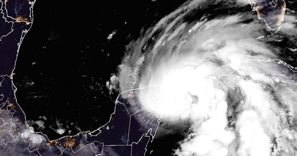
Helene is 110 miles north-northeast of Cozumel, Mexico, the National Hurricane Center said in a 2 p.m. advisory.
It’s expected to take a turn toward the northeast and increase its forward speed later today and tomorrow. That will likely bring Helene’s center across the eastern Gulf of Mexico to Florida’s Big Bend coast by tomorrow evening.
Helene is still forecast to strengthen and become a major hurricane by the time it reaches Florida.
“Preparations to protect life and property from storm surge and damaging winds along the Florida Big Bend Coast should be rushed to completion today,” the NHC warned.
Share![]()
Nearly every Florida county is under a state of emergency as Hurricane Helene moves through the Gulf of Mexico. NBC News’ Jesse Kirsch reports on how Gov. Ron DeSantis is preparing the state ahead of the expected winds.
Share![]()
Tallahassee Mayor John Dailey said that if the trajectory of Helene holds, the area will see “unprecedented damage like nothing we have ever experienced before as a community.”
Tallahassee, in the Big Bend area, is inland within the projected path of Helene’s landfall.
“If the city of Tallahassee is hit directly by a Category 3 hurricane, it’ll be the strongest hurricane in recorded history ever to hit our community. Current forecast continues to position us squarely within the cone of Hurricane Helene,” Dailey said in a news conference.
Locals should plan for a possible direct hit with winds in excess of 100 mph and flooding, he warned, adding that the city could see downed trees, structural damage and loss of power.
“Now is the time to prepare. We have no more time left to wait. Today is the day. We urge you to stay weather aware as we’re on the verge of what could be … a historic event,” Dailey added.
Aid resources from nine states — Missouri, Louisiana, Ohio, North Carolina, Arkansas, Pennsylvania, Kentucky, Michigan and Florida — are arriving in the area later today.
“By the sun setting this evening, we will have tripled our electric utility workforce,” he said, adding that when restoration begins, the goal is to increase it five-fold.
Share![]()
Tampa International Airport will suspend all commercial and cargo operations at 2 a.m. Thursday, ahead of Helene’s arrival.
The airport will remain closed to the public until damage assessments are completed, but it is anticipated to reopen Friday.
Three other public airports managed by the Hillsborough County Aviation Authority — Peter O. Knight, Tampa Executive and Plant City Airports — will also close at 2 a.m. Thursday, the airport said in a statement.
Share![]()
North Carolina Gov. Roy Cooper declared a state of emergency today ahead of the arrival of Hurricane Helene.
In his announcement, Cooper said Helene is forecast to trigger flash flooding, landslides, debris flows and river flooding across portions of the western and central part of the state. Tropical-storm-force winds are possible in the western part of the state late Thursday into Friday.
“Flooding may occur in areas that do not typically flood. All North Carolinians should be weather aware and prepared,” the statement said.
Georgia Gov. Brian Kemp also declared a state of emergency yesterday, as the southern part of the state was put under a tropical storm watch.
Share![]()
![]()
Helene will pass over unusually warm waters as it charges up from the Caribbean, which forecasters say will likely help the storm build intensity.
Sea surface temperatures in the Gulf of Mexico have been as hot as 88 degrees Fahrenheit in parts of the eastern Gulf Coast, according to the National Oceanic and Atmospheric Administration.
Brian McNoldy, a senior research associate at the University of Miami, posted on X earlier this month that the amount of heat energy stored in the Gulf of Mexico is “obliterating” previous records.
“It’s almost as if this matters…” McNoldy said in a follow-up post this morning.
Warm water acts like fuel for hurricanes, feeding storms energy and heat to gather strength at a rapid pace. Studies have shown that climate change is increasing ocean temperatures, which in turn is making storms stronger and increasing their intensity and destructiveness.
Share![]()
![]()
Mara Lezama Espinosa, the governor of Quintana Roo, Mexico, shared videos and photos of severe flooding and damage from Helene as the hurricane passes the Yucatán Peninsula.
She shared video of high tides at San Miguel Pier in Cozumel and cars submerged in flooded streets. Other posts showed downed trees, workers sweeping debris and intense rain.
“There are streets with fallen trees, power outages, strong gusts of wind and high waves,” she wrote on X. “Let’s take precautions! All emergency teams are in the territory and active on 911.”
Share![]()
![]()
NASA has delayed an upcoming SpaceX launch as Helene gathers strength and threatens Florida’s east coast.
SpaceX was scheduled to launch NASA astronaut Nick Hague and Russian cosmonaut Aleksandr Gorbunov tomorrow to the International Space Station. But the space agency opted to stand down, saying “the storm system is large enough that high winds and heavy rain are expected in the Cape Canaveral and Merritt Island regions on Florida’s east coast.”
The Falcon 9 rocket and Dragon capsule, which were out at the launch pad, were also rolled back to a hangar at Cape Canaveral Space Force Station Tuesday evening, NASA officials wrote in a blog post.
The upcoming mission, known as Crew-9, will now launch no earlier than Saturday at 1:17 p.m. ET.
Share![]()
Helene has become a hurricane, with 80 mph maximum sustained winds, the National Hurricane Center said in its 11 a.m. advisory.
It’s now about 85 miles north-northeast of Cozumel, Mexico, moving at 10 mph.
Share![]()
Some outer bands from Helene are already hitting the Florida Keys and Collier, Miami-Dade and Broward counties, Kevin Guthrie, the director of the Florida Division of Emergency Management, said in a news conference Wednesday.
“Sixty-four out of 67 counties need to pay attention to their alerts,” he warned as the state braces for what’s forecast to become a major hurricane.
Gov. Ron DeSantis said northern Florida will most likely be hit by Helene’s landfall, but impacts will be felt inland as well.
The governor had declared an emergency for 61 counties in the state. On Wednesday, he said FEMA partially approved the state’s pre-landfall emergency declaration, “but we didn’t get approved for what we think we need to get approved for.” He said the state will ask again for “more robust” approval.
The governor urged locals to familiarize themselves with their evacuation zones and be prepared to leave at a moment’s notice. The state is bracing for power outages, with 18,000 linemen already in Florida to restore power and more on the way. DeSantis said the National Guard is on standby and Starlink internet will be deployed as needed.
Share![]()
![]()
Wind: Tropical storm-force winds already extend 350 miles in diameter across the storm. Tropical storm conditions are expected in southern Florida later today, spreading northward through Thursday. Hurricane conditions are expected within the hurricane warning area late Thursday.
Helene is expected to be a massive hurricane with a wind swath of over 400 miles wide — that’s twice the size of Debby and Idalia, the last two hurricanes to slam the Big Bend.
Surge: Rivers across Florida will see significant surge, with the highest forecast to be 10 to 15 feet from the Ochlockonee River to Chassahowitzka. Tampa Bay will see 5 to 8 feet surge.
Rain: 32 million people are already under flood watches from South Florida to southern Virginia. Highest rainfall totals of up to 15 inches will be near landfall and in the southern Appalachians over Georgia, North Carolina and South Carolina.
Tornadoes: 12 million people are under risk for tornadoes Thursday from central Florida to central South Carolina. Tornado threat will be maximized across the Georgia coast. On Friday, the tornado threat shifts to eastern North Carolina and Southern Virginia.
Share![]()
![]()
![]()
Helene is forecast to make landfall along the Big Bend of Florida tomorrow night between 6 and 10 p.m. as a major hurricane.
Helene’s outer rain bands will bring on-and-off tropical downpours to South Florida and the Keys by this afternoon. Tropical storm-force winds will begin for Key West to Miami by later this evening.
Tomorrow, wind gusts 60 mph and higher, tornadoes, and storm surge flooding are expected along the west coast of Florida, including the Tampa area. Conditions will then quickly go downhill for the Florida Panhandle and Big Bend area by tomorrow afternoon.
Tomorrow night, Helene is forecast to make landfall and hurricane-force wind gusts are likely for the I-10 corridor across Florida and into southern Georgia. Major wind damage and power outages are likely along with significant urban and river flooding.
On Friday, Helene is forecast to remain strong as it pushes inland. It could maintain hurricane strength into southern Georgia. Major wind and rain impacts from north Georgia into the western Carolinas are forecast. Life-threatening flash flooding is expected for parts of Georgia, North Carolina and South Carolina.
Share![]()
Tropical Storm Helene is nearing hurricane strength with maximum sustained winds of 70 mph. A Category 1 hurricane has winds of 74 to 95 mph under the Saffir-Simpson Hurricane Wind Scale.
It’s forecast to become a hurricane later today and rapidly strengthen into a major hurricane on Thursday, the National Hurricane Center said in its 8 a.m. advisory.
Swirling about 60 miles east-northeast of Cozumel, Mexico, Helene is moving northwest at almost 9 mph. Helene is forecast to pass near the northeastern coast of the Yucatan Peninsula this morning, and move across the eastern Gulf of Mexico later today and Thursday, and reach the Big Bend coast of Florida late Thursday.
A tropical storm warning, already in effect for all of the Florida Keys, the Florida west coast from Flamingo to Anclote River, including the Tampa Bay, has been extended to include the Florida east coast from Flamingo northward to Altamaha Sound, Georgia.
Share![]()
View the full list of evacuation orders here.
Share![]()
![]()
Emergency evacuations are underway in Florida as Tropical Storm Helene is expected to grow into a massive and destructive Category 3 hurricane. “TODAY’s” Al Roker tracks the projected path of the storm.
Share![]()
President Joe Biden last night declared an emergency in Florida and authorized the Federal Emergency Management Agency (FEMA) to coordinate disaster relief efforts as Helene approaches.
Florida Gov. Ron DeSantis had requested the disaster declaration on Monday and he declared a state of emergency in 61 counties in the state.
The president’s authorization will see federal assistance and reimbursement for “mass care including evacuation and shelter support.”
Share![]()
![]()
The University of South Florida ia taking no chances as the state braces for the impact of Tropical Storm Helene tomorrow, likely as a hurricane.
The college has canceled all classes through Monday and closed access to its campuses until at least Friday.
“The University of South Florida continues to monitor Tropical Storm Helene. The safety of our students, faculty and staff is our highest priority as we track the storm and the possible impacts to the Tampa Bay region,” the college said in a statement this morning.
Share![]()
![]()
Florida is set to be hit hard by Tropical Storm Helene, forecasters said today, ahead of its likely arrival as a hurricane late tomorrow.
The National Hurricane Center said in a 5 a.m. ET update that its list of warnings and watches had grown overnight, with a hurricane warning already in place for Florida’s west coast, from Mexico Beach to the Anclote River.
A hurricane watch is in place for a stretch of coastline from the river down to Englewood.
“Preparations to protect life and property should be rushed to completion,” the NHC said.
A storm surge warning, meaning there is danger of life-threatening inundation in the next 36 hours, is in place for almost the entirety of Florida’s west coast from Indian Pass, south-east of Panama City, down to Flamingo in the Everglades National Park on the tip of the peninsular. This warning includes Tampa Bay and Charlotte Harbor.
Across the upper portion of the west coast, the storm surge could reach between 10 and 15 feet.
And a tropical storm warning is in place for Florida’s west coast, much of the east coast, and all the Florida Keys.
Share![]()
A few visitors at the tourist hotspot Cancun were still on the beach on Tuesday, despite warnings that Helene was approaching Mexico’s Caribbean coast.
Share![]()
NBC News meteorologist Angie Lassman on Early Today forecasts the direction, size and strength of Helene as it heads toward Florida.
Source link : http://www.bing.com/news/apiclick.aspx?ref=FexRss&aid=&tid=66f4bccab0de4128b9ad2b775a9fa154&url=https%3A%2F%2Fwww.nbcnews.com%2Fnews%2Fweather%2Flive-blog%2Fstorm-helene-live-updates-rcna172604&c=13138858571584074220&mkt=en-us
Author :
Publish date : 2024-09-25 14:11:00
Copyright for syndicated content belongs to the linked Source.