NOAA/National Hurricane Center
It could become a major hurricane by the time it nears Bermuda, potentially reaching Category 3 on the Saffir-Simpson scale, which ranks hurricanes based on their maximum sustained wind speeds and, relatedly, their capacity to cause serious damage. Hurricanes that fall within Category 1 or 2 on the scale are still dangerous and destructive. Ernesto’s sustained winds would need to reach at least 111 mph to meet criteria for Category 3.
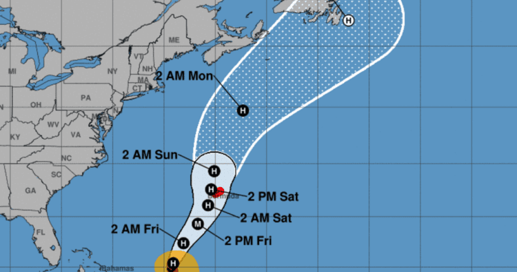
CBS News senior weather and climate producer David Parkinson said Thursday that Ernesto making landfall in Bermuda was “still in the realm of possibility, but it’s more likely the center of the storm will stay about 50 miles offshore.”
Ernesto became the fifth named storm of the 2024 Atlantic hurricane season when it formed Monday on a fast-moving path to the Caribbean. The storm came on the heels of Hurricane Debby, which lashed parts of the southeastern United States last week with disastrous flooding and severe weather that ultimately touched much of the East Coast. Ernesto isn’t expected to strike the U.S. mainland, the hurricane center said.

NOAA/National Hurricane Center
Rainfall from Ernesto was expected to begin in Bermuda later on Thursday, according to the hurricane center, which warned of the potential for flash flooding on Friday and through the weekend.
“Ernesto is expected to produce total rain accumulations of 4 to 8 inches in Bermuda with isolated maximum amounts up to 12 inches,” the center said. “This rainfall may result in considerable life-threatening flash flooding.”
It also warned of “dangerous storm surge” and “significant coastal flooding on Bermuda in areas of onshore winds,” as well as “large and destructive waves.”
A prolonged period of strong winds and storm surge is expected on Bermuda beginning late Friday, and residents were urged to rush to complete their preparations for the storm.

NOAA/National Hurricane Center
Swells fueled by Ernesto were affecting parts of the northern Leeward Islands, the Virgin Islands, Puerto Rico, the Dominican Republic, the Turks and Caicos Islands, and the southeastern Bahamas on Thursday morning. Forecasters said those swells would spread toward the rest of the Bahamas and Bermuda later in the day.

NOAA/National Hurricane Center
“Even though Ernesto is forecast to remain well offshore of the U.S. East Coast, swells generated by the storm are expected to reach the area late this week and into the weekend,” said the hurricane center. “Beach goers should be aware of a significant risk of life-threatening surf and rip currents, and stay out of the water if advised by lifeguards.”
Dangerous surf conditions and rip currents were also possible on the Virgin Islands, Puerto Rico, the Dominican Republic, the Turks and Caicos and the Bahamas during the next few days, the center said.
Editor’s Note: An earlier version of this story reported 975,000 customers had lost power in Puerto Rico, but that was the number of customers who still had power, according to Puerto Rico’s electricity provider.
More from CBS News
Emily Mae Czachor
Source link : http://www.bing.com/news/apiclick.aspx?ref=FexRss&aid=&tid=66be86cbe6094ab2a0fb3da1faa10a76&url=https%3A%2F%2Fwww.cbsnews.com%2Fnews%2Fmaps-show-tropical-storm-ernestos-path-and-forecast-as-it-passes-north-of-puerto-rico%2F&c=12056036039127645808&mkt=en-us
Author :
Publish date : 2024-08-15 04:29:00
Copyright for syndicated content belongs to the linked Source.


