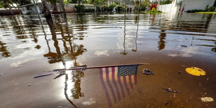
From high above, Hurricane Helene’s swirling clouds seem to have taken a piece of the United States and swallowed it whole. Helene, which made landfall last night as a Category 4 storm, has drenched the Southeast from the tip of Florida all the way up to North Carolina. Even though it weakened to a tropical storm this morning, streets have transformed into rivers, dams are threatening to fail, and more flooding is still to come. At least 22 people have died in the Southeast. Millions are without power. Florida’s Big Bend region, where Helene came ashore, had never faced such a strong hurricane in recorded history.
Helene arrived during an Atlantic hurricane season that forecasters had predicted would be unprecedented, thanks to record-warm ocean temperatures proffering extra fuel for storms. Since Hurricane Beryl swept over the Gulf Coast in July, the season has been quieter so far than the most dire expectations—but still unusually intense for Americans living in hurricane country. On average, one or two hurricanes make landfall in the U.S. per season. Helene is the fourth to come ashore on the Gulf Coast this year. This has only occurred a handful of times since the mid-1800s, with six as the record for landfalls on the U.S. mainland in a single season. This season isn’t over yet, so topping that record isn’t out of the realm of possibility.
“I wouldn’t make too much of that other than bad luck,” Brian McNoldy, a senior research scientist at the University of Miami, told me of the season’s landfall count so far. Helene and most other storms this season have emerged in the western part of the Atlantic basin, which has always been more favorable for storm growth and increases the likelihood of landfall, McNoldy said. Climate change isn’t to blame for where a hurricane touches down, or if it does at all. But Helene’s strength is a different kind of bad luck—a variety that we humans inadvertently engineered. Many of the hurricanes that do reach land these days are more intense because of oceans warmed by climate change. Decades ago, Helene might have become a medium-size storm—still destructive, but not a beast. This hurricane is a sign of America’s relentless hurricane seasons to come.
For months now, the waters in the Gulf of Mexico have been abnormally hot, spiking several degrees over the past decade’s average temperatures. “It is simply not within or even close to the range of natural variability to have water temperatures this far above normal in the Gulf, over this wide of an area, to that deep of a depth,” Ryan Truchelut, a meteorologist in Florida who runs the consulting firm WeatherTiger, told me. “When the other ingredients you need to form a hurricane are present, the results are explosive.” In Helene’s case, those other ingredients included the state of hurricane-slowing winds (low) and hurricane-bolstering moisture in the air (plenty), Phil Klotzbach, a meteorologist at Colorado State University, told me. Its massive size was also due to happenstance—a low-pressure system that spun over the Caribbean and Central America a few days before Helene reached the Gulf Coast. Such vortexes are quite common around this time of year, Klotzbach said.
These and other factors can make or break a hurricane. If the atmosphere is too dry, or if the wind shear is too intense, storms may never spin their way into Category 1. The problem is that, when atmospheric conditions allow a storm to form, our warming, moistening world is poised to grow them into major threats. “Even 100 years ago, the Gulf would have been plenty warm to support a hurricane of Helene’s strength,” Klotzbach said. But in this century, the chances of this particular outcome are simply higher. Gulf waters may certainly be cooler than average in some years, and perhaps that will be the case next year, which is forecast to be less scorching overall. “But the odds of that go down with continued climate change,” Klotzbach said.
Global warming doesn’t dictate whether storms like Beryl and Helene exist, but as Earth continues to heat up, more and more of the disasters that arrive on our shores will bear our fingerprints. “You hope, when you go into these years where the forecasts are really high, that maybe we’ll luck out; maybe we won’t get the big hurricane hits,” Michael Lowry, a hurricane specialist in Miami, told me. So far, the opposite situation is unfolding. And we still have two more months to go.
When I spoke with Truchelut at the start of the season, as Beryl strengthened in the Caribbean, he invoked the importance of chance in avoiding a nightmare hurricane, warning that “we might not be so lucky next time.” This week, Truchelut’s personal luck held out: Even as parts of Florida experienced a historic storm surge—the deadliest aspect of hurricanes, and one that is expected to worsen as sea levels rise—Tallahassee, where Truchelut is based, seems to have been spared. The more Atlantic storms make landfall as hurricanes, the greater the chances that each American town or city will face disasters shaped by a combination of natural misfortune and human-made blight. In our warming world, it seems that hurricane country won’t be able to catch a break.
Source link : http://www.bing.com/news/apiclick.aspx?ref=FexRss&aid=&tid=66f7c300d78b4c18914febf39b77924a&url=https%3A%2F%2Fwww.theatlantic.com%2Fscience%2Farchive%2F2024%2F09%2Fhurricane-helene-climate-change%2F680050%2F&c=15506411261181431795&mkt=en-us
Author :
Publish date : 2024-09-27 06:47:00
Copyright for syndicated content belongs to the linked Source.


