Hurricane Beryl has started making landfall in Jamaica as a category 4 storm. Yesterday it devastated several Caribbean islands, including Grenada.
The Prime Minister, Dickson Mitchell, said that there was no power, the roads were impassible and there was a possibility of the death toll rising, according to the Associated Press.
A hurricane warning remains in effect for Jamaica, the Cayman Islands and now the coast of Mexico’s Yucatan Peninsula from Puerto Costa Mayo to Cancun.
Loading…
Beryl is the strongest hurricane to form this early in the Atlantic Hurricane season, fueled by warm ocean waters.
Loading…
Jamaica has announced a state of emergency and a curfew has been put in place between the hours of 6 a.m. and 6 p.m. on Wednesday.
Lucanus Ollivierre / AP
/
AP
Family members survey their home destroyed in the passing of Hurricane Beryl, in Ottley Hall, St. Vincent and the Grenadines, Tuesday, July 2, 2024.
Lucanus Ollivierre / AP
/
AP
Evacuees from Union Island arrive in Kingstown, St. Vincent and the Grenadines, Tuesday, July 2, 2024. The island, in the Grenadines archipelago, was hit by Hurricane Beryl.
Victor Gonzalez / AFP via Getty Images
/
AFP via Getty Images
Residents try to recover their belongings from their flooded houses after a river swelled due to heavy rains following the passage of Hurricane Beryl on the road from Cumana to Cumanacoa, Sucre State, Venezuela, on July 2, 2024. Hurricane Beryl churned towards Jamaica Tuesday after killing at least five people and causing widespread destruction across the southeastern Caribbean, threatening deadly winds and storm surge as it approached.
Victor Gonzalez / AFP via Getty Images
/
AFP via Getty Images
People stand outside their flooded homes after a river swelled due to heavy rains following the passage of Hurricane Beryl on the road from Cumana to Cumanacoa, Sucre State, Venezuela, on July 2, 2024. Hurricane Beryl churned towards Jamaica Tuesday after killing at least five people and causing widespread destruction across the southeastern Caribbean, threatening deadly winds and storm surge as it approached.
July 1
Ricardo Mazalan / AP
/
AP
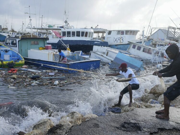
Fishermen pull a boat damaged by Hurricane Beryl back to the dock at the Bridgetown Fisheries in Barbados, Monday, July 1, 2024.
This image provided by NASA shows Hurricane Beryl from the International Space Station on Sunday, July 1, 2024. Beryl was roaring toward Jamaica on Wednesday, July 3, with islanders scrambling to make preparations after the powerful Category 4 storm earlier killed at least six people and caused significant damage in the southeast Caribbean.
Ricardo Mazalan / AP
/
AP
A fisherman looks at fishing vessels damaged by Hurricane Beryl at the Bridgetown Fisheries in Barbados, Monday, July 1, 2024.
June 30
Copyright 2024 NPR
Chandan Khanna / AFP via Getty Images
/
AFP via Getty Images
A man screws a board onto the window of a shop in preparation for the arrival of Hurricane Beryl in Bridgetown, Barbados on June 30, 2024. Beryl, the first hurricane of the 2024 Atlantic season, strengthened into an “extremely dangerous” Category 4 storm Sunday as it threatened the southeast Caribbean with potentially life-threatening winds and storm surge, US trackers said.
Chandan Khanna / AFP via Getty Images
/
AFP via Getty Images
Vehicles line up at a gas station as people prepare for the arrival of Hurricane Beryl in Bridgetown, Barbados on June 30.
People disassemble a beach bar’s awning in preparation for Hurricane Beryl, in Bridgetown, Barbados, Sunday, June 30.
Source link : https://www.kalw.org/npr-news/2024-07-03/photos-see-the-path-of-destruction-from-hurricane-beryl
Author :
Publish date : 2024-07-03 17:45:00
Copyright for syndicated content belongs to the linked Source.
