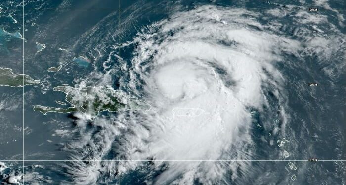
The center of Tropical Storm Ernesto passed over the Virgin Islands east of Puerto Rico late Tuesday, bringing rounds of torrential rainfall to the U.S. territories that continued into Wednesday morning.
San Juan, Puerto Rico, radar loop from around 2 PM local Tuesday to 8 AM local Wednesday. Notice the developing core of Ernesto on radar with nascent eye in the final few frames. (Mark Nissenbaum/Florida State University)
Winds gusted to 74 mph on the eastern edge of Puerto Rico during the pre-dawn hours Wednesday. So far over up to 7 inches of rain has fallen, mainly south and east of San Juan in Puerto Rico and across parts of the nearby islands of Vieques, Culebra, and St. Thomas in the U.S Virgin Islands.
Another 4 to 6 inches of rainfall is forecast for parts of southeastern Puerto Rico as Ernesto’s long tail of rainfall scrapes over the island today.
(WPLG)
By the time it’s all said and done, close to a foot or more of total rain is possible for parts of Puerto Rico and flash flooding with dangerous mudslides and landslides in higher terrain will be ongoing threats today.
Treacherous marine conditions with seas topping 10 feet and dangerous, life-threatening surf will persist for much of the day.
Ernesto almost a hurricane, could threaten Bermuda this weekend
Ernesto is now centered north of Puerto Rico and will continue to turn northward and away from the islands on Wednesday, passing northeast of the Dominican Republic and Haiti.
Multiple hurricane hunter aircraft flying Ernesto this morning are finding winds very near hurricane strength with a better-defined core. It won’t be long until Ernesto is upgraded to the 3rd hurricane of the 2024 season, almost a full month ahead of when we typically see our third hurricane in the Atlantic.
(WPLG)
As we’ve covered in newsletters since last week, conditions in the western Atlantic are ripe for strengthening and the official forecast from the National Hurricane Center now takes Ernesto to a Category 3 major hurricane by early Friday as it curls toward Bermuda.
Though the small archipelago of Bermuda occupies a tiny footprint in the western Atlantic, it remains squarely in the crosshairs of Ernesto’s future path.
Hurricane Watches could be required for Bermuda as soon as today as tropical storm conditions will likely begin affecting the British Overseas Territory by later in the day Friday.
Caption: Probability of Ernesto passing within about 100 miles of a given location based on the overnight runs of all reliable global forecast models. Today’s models continue to show a strong signal for Ernesto passing near Bermuda by Friday into Saturday. Interests in the British Overseas Territory should follow the forecasts closely. (Tomer Burg/University of Oklahoma)
Those with interests in Bermuda should follow Ernesto’s forecasts closely as a major hurricane could be nearby on Saturday.
Though Ernesto isn’t a direct threat to the U.S., its large and powerful wind field will produce a significant swell that will lead to rough conditions up and down the Eastern Seaboard this weekend.
Expect dangerous surf and a high risk of life-threatening rip currents from the southeast and mid-Atlantic to the northeastern U.S. coast beginning later tomorrow into Friday.
Wave forecast from the American GFS model from late Thursday through next Monday morning showing significant swell reaching the U.S. east coast by late tomorrow and into the weekend, which will raise the risk for life-threatening rip currents and dangerous swell along area beaches. (Weathermodels.com)
For those with late summer beach plans, be on the lookout for red flags signaling a high rip current risk and avoid the water when the rip current risk is high.
No additional development expected into next week
While disturbances will continue to push through the tropical Atlantic next week, our models continue to be ho-hum on development for the near term.
Things can change in a jiffy in August, so we’ll stay vigilant but for now we should be able to enjoy a quiet start to next week.
Copyright 2024 by WPLG Local10.com – All rights reserved.
Source link : http://www.bing.com/news/apiclick.aspx?ref=FexRss&aid=&tid=66bd6f4c04504f2a8fb9e7d7c8896715&url=https%3A%2F%2Fwww.local10.com%2Fweather%2Fhurricane%2F2024%2F08%2F14%2Fernesto-dousing-puerto-rico-and-the-us-virgin-islands-forecast-to-become-hurricane%2F&c=4874090944561678326&mkt=en-us
Author :
Publish date : 2024-08-14 07:51:00
Copyright for syndicated content belongs to the linked Source.


